The National Weather Service says six EF-2 tornadoes swept through Iowa Friday night
Multiple ''large and extremely dangerous" tornadoes touched down across western and central Iowa Friday, April 26, including near Pleasant Hill on the eastern side of the city, according to the National Weather Service.
The town of Minden suffered significant damage, according to state officials. But no fatalities have been reported.
The storms were part of a strong system that swept eastward across the state Friday, bringing heavy rain and large hail as tornado watches and warnings were issued county by county.
Showers and storms are likely again on Sunday, the National Weather Service says, particularly by mid to late afternoon and into the evening.
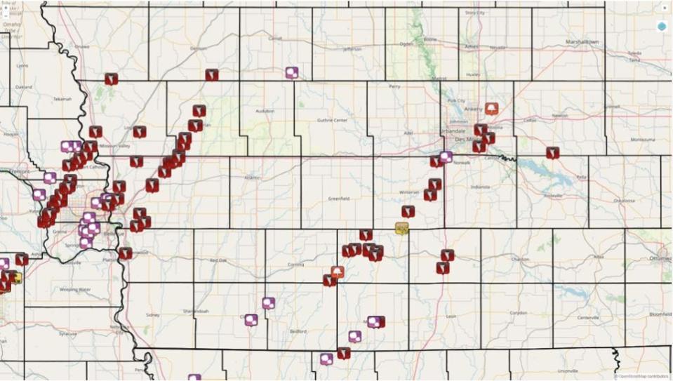
The National Weather Service has also released preliminary information for nine of Friday's tornadoes.
Six of the nine National Weather Service-confirmed tornadoes have been classified as EF-2. A pair of EF-2 tornadoes traveled parallel to each other near Afton, while the weakest and shortest-lived tornado was confirmed near Maffit in Madison County and classified at EF-0.
The National Weather Service has not yet categorized the Minden tornado that destroyed the small western Iowa town on Friday. Additional surveys are forthcoming and more paths may be discovered, according to the NWS.
2:30 p.m.: Minden, Iowa man dies from injuries following tornado
A man injured during a tornado that touched down in Minden, Iowa has died, Pottawattamie County Emergency Management officials confirmed Sunday.
The Minden resident was found after the tornado hit and was taken to a local hospital Friday, April 26. He was later transported to a trauma center in Omaha. He passed away in the overnight hours Saturday, according to Pottawattamie emergency management director Doug Reed.
Officials declined to release further identification information about the man.
Three Pottawattamie County residents were injured on Friday night, according to Reed. They were treated and released.
Since then, three more have suffered minor injuries during clean-up and recovery, including one responder and two community members.
More: Minden, Iowa man dies from injuries sustained in tornado
1 p.m.: Storms with wind, hail possible for Sunday afternoon
A Sunday afternoon storm system has a chance chance of producing a few tornadoes, according to the National Weather Service.
Officials are unsure exactly when the severe weather will hit, as cloud cover and showers could limit intensity.
The highest chance for severe storms is between 3 p.m. and 9 p.m. with the potential for hail up to 1.5 inches in diameter and damaging wind gusts up to 60 MPH.
Much of Iowa faces a "marginal risk" of severe weather, with southern Iowa at a "slight risk."
In the case of severe weather, officials encourage residents to seek shelter in a building or car.
The NWS suggests staying aware of weather warnings through tools like the NOAA Weather Radio, the mobile app and through TV and/or radio.
More: Pleasant Hill tornado classified as an EF-2 with max wind speeds of 125 MPH
12:30 p.m.: Gov. Reynolds visits residents impacted by tornado in Minden
Gov. Kim Reynolds traveled Saturday to Minden in the aftermath of an April 26 tornado that devastated the town of about 600 people.
In Minden viewing damage from yesterdays storms and talking with city officials and residents.
The people of Iowa are coming together, just like we always do, to help one another. With the possibility of more storms today, please be safe and look out for your neighbors. pic.twitter.com/z1RpixOpFM— Gov. Kim Reynolds (@IAGovernor) April 27, 2024
In a Twitter post, Reynolds posted pictures of her Saturday visit talking to residents and city officials.
"The people of Iowa are coming together, just like we always do, to help one another," Reynolds wrote. "With the possibility of more storms today, please be safe and look out for your neighbors."
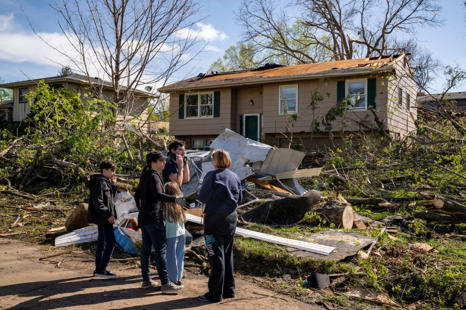
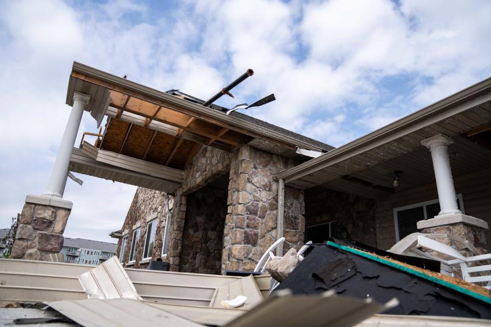
Minden, a small town in Pottawattamie County, suffered significant damage Friday night as severe storms and several tornadoes touched down across the state. The town reported damage to homes, cars and trees.
Four injuries had been reported by Saturday afternoon, according to a news release from Pottawattamie County emergency management. One person remains hospitalized in stable condition, as reported Saturday.
Reynolds issued a disaster proclamation for Pottawattamie County in response, which activated the Iowa Individual Assistance Grant Program and the Disaster Case Advocacy Program.
The Disaster Case Advocacy program provides up to $5,000 in grants for households with incomes up to 200% of the federal poverty level.
10:30 a.m., Sunday, April 28: NWS results show Pleasant Hill tornado reached 125 miles per hour
A tornado that touched down just before 9 p.m. west of Pleasant Hill Friday, April 26 has been confirmed as an EF-2 by the National Weather Service in Des Moines.
Friday's tornado reached a peak wind speed of 125 MPH, measuring about 300 yards wide. It swept across town for about seven miles for roughly 12 minutes, injuring at least one and damaging nearly 20 homes.
The tornado first touched down in southeast Des Moines near Indianola Avenue around 8:50 p.m., traveling for 7.2 miles past James W. Cownie Park and northeast through Pleasant Hill, toppling trees and power lines along the way.
(8/9) Pleasant Hill pic.twitter.com/NeQYOXxGPJ
— NWS Des Moines (@NWSDesMoines) April 28, 2024
According to the NWS, there have been zero deaths recorded due to the tornado.
10:30 a.m.: Three tornadoes batter Union County, NWS survey shows
Three tornados ripped through Union County on April 26, barrelling through Creston and near Afton, each exceeding wind speeds of 120 miles per hour.
The first Union County tornado is believed to have touched down at roughly 6:52 p.m. outside Creston. The EF-2 tornado traveled 6.8 miles to the northeast, with a width of 350 yards and an estimated peak wind speed of 125 MPH.
The first of two EF-2 tornadoes that traveled near Afton touched down at roughly 7:26 p.m. on April 26, traveling nearly 11 miles and lasting 18 minutes. The National Weather Service believes the tornado reached a maximum wind speed of 130 MPH and was 150 yards wide.
A second EF-2 tornado popped up a few minutes after the first expired, touching the ground almost in the same spot at 7:53 p.m. The NWS believes this tornado traveled 11.6 miles, lasting 12 minutes, with a maximum wind speed of 125 MPH and a width of 150 yards.
(2/9) Afton East pic.twitter.com/azmmzR3Oh8
— NWS Des Moines (@NWSDesMoines) April 28, 2024
10:30 a.m.: Two EF-2 tornadoes confirmed in Ringgold County
Ringgold County is recovering from destruction as well after a tornado touched down in Tingley and another near Mount Ayr.
An EF-1 tornado traveled nearly 27 outside Mount Ayr and reached speeds of about 110 mph. The twister touched down at 7:27 p.m. and lasted until 8:08 p.m. No injuries or fatalities were reported.
An EF-2 tornado ripped through Tingley on April 26, traveling about 10 miles starting around 8:19 p.m. At its peak, it reached 125 MPH, destroying homes and the Tingley Community Center.
No injuries or deaths were reported.
(5/9) Tingley pic.twitter.com/aFswJjyeRr
— NWS Des Moines (@NWSDesMoines) April 28, 2024
10:30 a.m. Osceola tornado produced high wind speeds
An EF-2 tornado was confirmed to have torn through Osecola on April 26, producing some of the strongest confirmed wind speeds. The twister was just 75 yards in width but is believed to have reached a speed of 135 MPH during its 12-minute, nearly seven-mile jaunt through the county.
The NWS indicates the tornado first touched down west of Interstate 35 before heading northeast, hopping the interstate and through the heart of downtown Osecola. The tornado eventually dissipated a few miles northeast of town.
(7/9) Osceola pic.twitter.com/VQO7cr4zit
— NWS Des Moines (@NWSDesMoines) April 28, 2024
10:30 a.m.: Madison, Jasper counties also experience confirmed tornadoes
An EF-0 tornado touched down around 8:23 p.m. on April 26 in Maffit in Madison County and reached peak wind speeds of 80 mph. The tornado traveled just 1.7 miles, lasting three minutes with a width of 30 yards.
An EF-1 tornado touched down around 9:42 p.m. in Monroe, Jasper County, and reached 105 MPH, traveling just two miles and 50 yards wide. No injuries or deaths resulted from these twisters.
(1/9)Here are the preliminary storm survey results for the tornadoes that impacted portions of central Iowa on April 26th. Additional surveys will be forthcoming and more paths may be discovered. #iawx
Creston #1 pic.twitter.com/B8Tpcix0Vh— NWS Des Moines (@NWSDesMoines) April 28, 2024
2 p.m., Saturday, April 27: NWS issues tornado watch for several southern Iowa counties
A tornado watch has been issued for parts of Iowa, Kansas and Missouri until 9 PM CDT pic.twitter.com/I1YojLiyrL
— NWS Des Moines (@NWSDesMoines) April 27, 2024
The Des Moines National Weather Service has issued a tornado watch for several southern Iowa counties that will be in effect until 9 p.m. Saturday.
The tornado watch includes the towns of Creston, Centerville, Indianola, Ottumwa, Centerville, and Oskaloosa, among others. The storm system, according to the National Weather Service, is capable of producing a few tornadoes and wind gusts up to 75 MPH. The system could also produce hail up to two inches in diameter.
1:30 p.m.: Polk County officials issue statement on tornado impact
The Polk County Emergency Management Agency has been out much of Saturday assessing the damage and coordinating resources for residents in need.
Polk County officials are organizing a call for volunteer help in Pleasant Hill. Authorities say monetary donations can be sent to the Polk County and Greater Des Moines Community Foundation disaster recovery fund.
“We are saddened by the widespread damage caused by the tornadoes and storms in Pleasant Hill and across Polk County.” Polk County Board Chair Angela Connolly said in a press release. “Our primary focus right now is on ensuring the safety and well-being of all our residents. We are working closely with local first responders, utility crews, and volunteer organizations to provide assistance and support to those impacted by this disaster."
1 p.m.: National Weather Service provides statewide damage update
Brooke Hagenhoff, a meteorologist with the National Weather Service, said there were at least 10 tornados that swept through central Iowa on April 26.
Several other tornadoes reportedly touched down in western Iowa near Council Bluffs and the Nebraska border.
Compared to the storm system the state endured earlier in the month, Hagenhoff said Friday night’s storm system was much more robust.
Chris Franks, a meteorologist for the NWS based in Nebraska, said roughly three tornadoes originated in Omaha and traveled east across Iowa’s border.
“Right now, it's pretty good to estimate that there tornadoes that came from Nebraska, or very near the Iowa Nebraska line, and then and then crossed into Iowa,” Franks said. “I will caveat that the damage surveys are still on very much ongoing, in fact, there's a lot of a lot of damage to survey.”
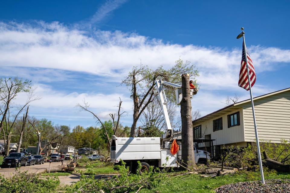
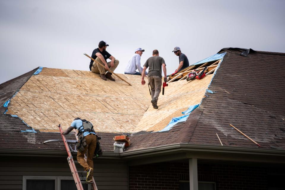
11:45 a.m.: Tornado destroys homes, power lines in Pleasant Hill
A tornado touched down just west of Pleasant Hill around 9 p.m. Friday, April 26, sweeping across town, injuring one and damaging nearly 20 homes.
Pleasant Hill Fire Department Chief Jamie Xayavong told reporters at an 11 a.m. news conference Saturday that the injury was not life-threatening, though the 18 damaged homes were no longer inhabitable.
The tornado is believed to have touched down near the intersection of Parkridge Avenue and E Oakwood Drive and headed east, toppling several trees and power lines along the way.
Xayavong said storm damage has been reported as far east as NE 80th Street.
The fire chief did not know how strong the tornado was, though it left several other homes with moderate or minor damage. She indicated that more damage reports could come in as recovery continues.
None of the misplaced residents needed emergency shelter, Xayavong said.
More: Trees downed, homes damaged in Pleasant Hill after tornadoes sweep through area.
11:15 a.m.: Reports of Friday night tornado in Ringgold County in southwest Iowa

A tornado swept through the small southwestern Iowa towns of Tingley and Redding on Friday, April 26, according to Melissa Stark with Ringgold County Emergency Management. Officials believe the tornado developed around 8 p.m. Friday, traveling the entire length of the county and leaving significant damage in its wake.
Stark said residents had little warning, noting that the sirens weren’t triggered until the tornado had developed.
The storm system decimated the Tingley Community Center and devastated the city park.
No injuries have been reported.

11 a.m.: Creston recovering from storm damage
U.S. Rep. Zach Nunn said he was headed to Creston to meet with the Union County Sheriff to tour the community and offer his support.
The storm damaged portions of the Homestead Assisted Living's roof in the northwest part of town. Several windows and the main entrance also suffered damage. A private home in Creston was also damaged in the storm.
“Iowa just emerged from a horrible event that occurred many of our communities last night. In fact, we're headed down to Union County next to help take care of Creston and the communities that were impacted by horrible storms and tornadoes that ravaged the state of Iowa,” he said at a campaign event Saturday morning. “Our prayers not only are with Minden but those communities in Nebraska where we've flown flight operations out of. They're just decimated. And so this morning as we think about what we need to do, it should always be about how do we help those communities in need.”
U.S. Highway 34 between Creston and Afton was closed Friday night due because debris blocked the road, according to Iowa 511.
11 a.m.: Where is Minden, Iowa?
Minden is located on the western side of Iowa. It’s about a 30-mile drive from Omaha, Nebraska, depending on the route taken, according to Google Maps. The town was settled in 1875 by German immigrants, according to Travel Iowa.
The town of about 600 faced damage to homes, cars and trees after a tornado swept through Friday, April 26. Pottawattamie County officials confirmed four injuries as of Saturday morning, according to KETV.
Gov. Kim Reynolds issued a disaster proclamation for the county in response, which activated the Iowa Individual Assistance Grant Program and the Disaster Case Advocacy Program.
The Disaster Case Advocacy program provides up to $5,000 in grants for households with incomes up to 200% of the federal poverty level.
More: Where is Minden, Iowa? What we know on the Iowa tornado that caused significant destruction
10:45 a.m.: Tiny Minden, Iowa, riddled with debris after tornado smashes through town Friday
Many houses, cars, and trees in Minden have been destroyed after a tornado devastated the southwestern Iowa town of roughly 600 people Friday evening, April 26.
Access to the town was shut off Saturday because of the destruction.
Drivers trying to pass through Minden Saturday morning were being redirected as workers tried to clean up wholesale debris left behind.
For Austin Ehlers, a firefighter in Persia, a city just about 15 minutes away from Minden, the tornado demolished his grandfather’s home.
“He lives just outside of Minden, right in the path where the tornado took,” Ehlers said. “After we cleared everything in Persia, we hoped in the trucks and went to Minden and helped. I found out my grandpa’s house was completely gone, and he’s basically lost everything.”
More: Tiny Minden, Iowa, riddled with debris after tornado smashes through town Friday
10:30 a.m.: Are more tornadoes headed for Iowa? The National Weather Service forecast
Is another round of tornadoes heading to Iowa?
One day after bands of tornadoes swept through western and central Iowa Friday, the National Weather Service is warning of the possibility of strong to severe storms Saturday afternoon through the evening.
"All severe weather hazards are possible, but hail and damaging winds are the primary threats," the National Weather Service in Des Moines reported.
More: Could more tornadoes be headed to Iowa? The National Weather Service forecast
Showers and storms continue into Sunday, along with the potential for more strong to severe storms Sunday afternoon and evening, the NWS said.
"The extent of the threat and most likely hazards remains uncertain at this time," it posted.
The NWS warned that spotter activation may be needed later Saturday and Sunday.
Chances for showers and storms return Tuesday into Tuesday night, and again late in the week. The severe weather threat is uncertain and will be evaluated in the coming days.
Preparing for a storm
With the potential for more severe weather, it's good to be prepared. Make sure you have a plan in place. Here are five things you should know to be prepared for a weather emergency.
6:15 a.m.: At least 10 tornadoes hit central Iowa, National Weather Service says
The National Weather Service in Des Moines posted early Saturday morning that preliminary reports indicate at least 10 tornadoes struck central Iowa in the April 26 storm front, based on initial damage information.
Another band of tornadoes swept across Nebraska and western Iowa.
Rough timeline of events for last evening's severe weather. We will share more damage information as it comes available from our survey teams.
Remember, round 2 comes up later this afternoon/evening! Are you prepared? #iawx pic.twitter.com/iftjOxKZDt— NWS Des Moines (@NWSDesMoines) April 27, 2024
Damage to trees and homes were reported from Crawford to Union to Ringgold up to Polk and Jasper counties, the office said. At least one injury was reported.
In Nebraska and western Iowa, a swath of damage stretched from just northeast of Lincoln, Nebraska, through the Waterloo and Elkhorn areas, and all the way to near Soldier, Iowa, in eastern Monona county. NWS Omaha issued 42 tornado warnings during the outbreak, it reported.
Two NWS teams from the Des Moines office will survey damaged areas on Saturday. The office will begin to post survey results Saturday, but it will likely take days to rate the severity and path of all the touchdowns.
Severe weather threat develops again later this afternoon into the evening. An Enhanced Risk is outlooked across portions of southern into central Iowa.
Remain weather aware and having multiple ways to receive warning information! #IAwx pic.twitter.com/RnBl2hVGHJ— NWS Des Moines (@NWSDesMoines) April 27, 2024
11:15 p.m.: Minden, Iowa, appears to be hardest hit by Friday's system; storms may continue through the weekend
Friday’s system ushered strong storms across the state, leaving widespread debris and devastation in their wake.
The small town of Minden in northcentral Pottawattamie County appears to have suffered some of the most significant damage, according to state officials and storm chasers, who posted photos and videos of leveled houses and businesses.
As of about 11 p.m. Friday night, no fatalities had been reported in the town, which is 90 minutes west of Des Moines on I-80.
In response to the severe weather, Gov. Kim Reynolds issued a disaster proclamation for Pottawattamie County. The proclamation initiates the Iowa Individual Assistance Grant Program and the Disaster Case Advocacy Program.
Saturday could see more scattered thunderstorms in the afternoon, a few of which could be serve and bring heavy rain. Those storms may continue through Sunday morning.
I have approved a Proclamation of Disaster Emergency for Pottawatamie County to support storm recovery efforts in Minden.
Continuing to monitor the storm and the situation. https://t.co/TwXScKa3sy— Gov. Kim Reynolds (@IAGovernor) April 27, 2024
Staying weather aware will be important for the rest of the weekend. Look out for wireless emergency alerts on your smartphone or stay up to date on forecasts at weather.gov/desmoines.
A few other tips for staying safe:
Get in: If you are outside, get inside. If you're already inside, get as far into the middle of the building as possible.
Get down: Get underground if possible. If you can't, go to the lowest floor possible.
Cover up: Flying and falling debris are a storm's number one danger. Use pillows, blankets, coats, helmets to cover up and protect your head and body from flying debris.
Video of the Minden, Iowa wedge tornado as it crossed I-80 just to my west. Unreal day. #iawx pic.twitter.com/gzZWLSOvfE
— Alex Resel 📸 (@aresel_) April 27, 2024
11 p.m.: Severe thunderstorm 'capable of producing a tornado' spotted over Knapp Center and Drake Stadium
A severe thunderstorm 'capable of producing a tornado' was seen over Drake Stadium and the Knapp Center, according to the National Weather Service. The system was moving northeast at 45 mph.
A tornado warning was issued for central Polk County until 11:45 p.m.
"Flying debris will be dangerous to those caught without shelter," said the NWS. "Mobile homes will be damaged or destroyed. Damage to roofs, windows and vehicles will occur."
Drake University is hosting the Drake Relays. No information on delays or cancelations for Saturday's events had been announced by 11:15 p.m. Friday.,
10:10 p.m.: Metro under tornado watch until midnight; one tornado warning lingers
After an evening of strong storms that brought multiple “large and dangerous” tornadoes, heavy rain and sizable hail, most of the system has dissipated.
The last tornado warning issued in the area was in northeast Jasper County and expired at 10:30 p.m.
Metro counties Polk, Warren, Madison and Jasper — as well as many southcentral counties — are still under a watch until midnight.
Full list of counties remaining under a tornado watch until midnight:
Adams
Appanoose
Clarke
Decatur
Jasper
Lucas
Madison
Marion
Monroe
Polk
Ringgold
Taylor
Union
Warren
Wayne
10 p.m.: Cross-streets completely blocked in Pleasant Hill
Several cross-streets are completely blocked by emergency crews and tree debris south of the Pleasant Hill Hy-Vee. Lots of traffic seem to be trying to leave the surrounding neighborhoods, which are without power.
9:45 p.m.: 15,000 MidAmerican customers without power
There are about 15,000 MidAmerican Energy customers without power, according to the utility.
At least 11,843 east-side residents were without power, according to MidAmerican.
9:35 p.m.: Highway 34 closed between Creston and Afton; reunification center set up at local Walmart
U.S. Highway 34 between Creston and Afton closed Friday night due to debris blocking the road, according to Iowa 511.
A command center for ambulances and family reunification was set up at Walmart on Laurel St., according to the Creston Police Department. No fatalities or injuries have been confirmed as of about 9:30 p.m. in Creston, according to the police department.
9:30 p.m.: Zach Bryan concert will go on; 'Severe weather protocols' being followed
Zach Bryan's Quittin' Time Tour will go on as scheduled, according to the Iowa Events Center.
"We are following our established severe weather protocols while we are in a tornado warning," said Adam Flack, director of marketing for the arena. "The show will go on and we have closed the concourse until the warnings expire. Everyone is encouraged to stay inside the seating bowl away from entrances and glass."
9 p.m.: 'Large and extremely dangerous' tornado near Pleasant Hill
The National Weather Service has confirmed a "large and extremely dangerous tornado" over Pleasant Hill. It is moving northeast at about 35 mph.
Those in the area are in "a life-threatening situation," NWS said. "Flying debris may be deadly to those caught without shelter. Mobile homes will be destroyed. Considerable damage to homes, businesses, and vehicles is likely and complete destruction is possible."
The tornado warning issued for Southeastern Polk and Western Jasper Counties is extended until 9:30 p.m.
KCCI reported that the Pleasant Hill tornado was "lofting" debris into the air.
The system is "one of the most intense rotational signatures we've seen today," said meteorologist Jason Sydejko.
At Southeast Polk Jr. High School, a production of "Annie Jr." was stopped and the audience was ushered to shelter in the hallway.
8:50 p.m.: Tornado warnings issued for eight Iowa counties
The National Weather Service in Des Moines has issued tornado warnings until 9:30 p.m. for the following counties:
Southeastern Union County
Northeastern Ringgold County
Northeastern/west central Clarke County
Northwestern Lucas County
Northwestern/west central Marion County
Northeastern/southeastern Warren County
Southeastern Polk County
Western Jasper County
8:33 p.m.: 'Tornadic super cells' headed into Des Moines; Take shelter
Multiple tornadic super cells are making their way into the metro, according to KCCI.
Sirens have been heard across the metro area.
Urbandale and Clive residents should be in their safe spaces. Metro residents should also get to basements or below ground level.
Get in: If you are outside, get inside. If you're already inside, get as far into the middle of the building as possible.
Get down: Get underground if possible. If you can't, go to the lowest floor possible.
Cover up: Flying and falling debris are a storm's number one danger. Use pillows, blankets, coats, helmets to cover up and protect your head and body from flying debris.
Look out for wireless emergency alerts on your smartphone or stay up to date on forecasts at weather.gov/desmoines.
At 8:23 p.m., a confirmed tornado was located near Cumming, or near West Des Moines, moving northeast at 25 mph, according to the National Weather Service.
8:30 p.m.: Gov. Reynolds issues disaster proclamation for Pottawattamie County, where Minden was hit hard
In response to the severe weather Friday night, Gov. Kim Reynolds issued a disaster proclamation for Pottawattamie County. The proclamation initiates the Iowa Individual Assistance Grant Program and the Disaster Case Advocacy Program.
Minden, which was hit hard by a tornado earlier in the evening, sits in northern section of the county.
From a news release:
The Iowa Individual Assistance Grant Program provides grants of up to $5,000 for households with incomes up to 200 percent of the federal poverty level. Grants are available for home or car repairs, replacement of clothing or food, and temporary housing expenses. Original receipts are required for those seeking reimbursement for actual expenses related to storm recovery. The grant application and instructions are available on the Iowa Department of Homeland Security and Emergency Management website at homelandsecurity.iowa.gov/assistance. Potential applicants have 45 days from the date of the proclamation to submit a claim.
The Disaster Case Advocacy Program addresses serious needs related to disaster-related hardship, injury, or adverse conditions. Disaster case advocates work with clients to create a disaster recovery plan and provide guidance, advice, and referrals to obtain a service or resource. There are no income eligibility requirements for this program; it closes 180 days from the date of the governor's proclamation. For information on the Disaster Case Advocacy Program, contact your local community action association or visit iowacommunityaction.org.
8:26 p.m.: Tornado warning issued for Des Moines metro
The National Weather Service in Des Moines has issued a tornado warning for Polk, Madison, Dallas and Warren counties until 8:45 p.m.
The tornado warning includes:
Des Moines, West Des Moines, Ankeny, Urbandale, Johnston, Clive, Altoona, Waukee, Norwalk, Pleasant Hill, Grimes, Windsor Heights, Saylorville, Granger, Jordan Creek Town Center, Merle Hay Mall, Iowa Events Center, Iowa State Fairgrounds, Des Moines Int`l Airport, and Principal Park.
8:05 p.m.: Tornado watch extended to midnight in Polk, Story, Boone and Jasper Counties
The Tornado watch issued by the National Weather Service has been extended to midnight in 10 counties, including Polk, Jasper, Boone and Story counties. Further South, counties including Appanoose, Lucas, Marion, Monroe, Warren and Wayne are under the same watch.
The metro as well as larger population centers like Ames, Indianola, Newtown, Knoxville and Pella are now covered by the watch.
Possible threats connected to this storm system could include "a few tornados" with "a couple intense tornados possible," according to the National Weather Service. Damaging winds could gust to about 70 mph and scattered large hail, including pieces possibly measuring 2.5 inches in diameter, are also possible.
7:45 p.m.: Minden, Iowa, seems to be destroyed
Storm chasers have posted video and photos of what looks to be catastrophic damage in Minden, Iowa, located about 90 minutes west of Des Moines on I-80.
Cell phone clip shortly after the #tornado passed Minden, IA. Sony video to come of the tornado actually hitting town. This was very intense and we went back to the town to check on people shortly after. #iawx @Sierra_Lindsey3 @MyRadarWX @SevereStudios pic.twitter.com/UjvfgAD1gB
— Jordan Hall (@JordanHallWX) April 27, 2024
Devastating footage reveals catastrophic damage in Minden, Iowa, after a tornado emergency warned tornado swept through the southeastern side of the area#tornados #iowa
Posted by Iowa Pulse on Friday, April 26, 2024
7:45 p.m.: Tornado warning issued for southern Iowa counties
The National Weather Service in Des Moines has issued a tornado warning for southwestern Madison, central Union, western Clarke and southeastern Adair counties until 8:30 p.m.
7:45 p.m.: Tornadoes located over Creston, Mount Ayr
At 7:43 p.m., NWS confirmed a tornado located over Creston Municipal Airport moving northeast at 35 mph.
At 7:47 p.m., NWS confirmed a tornado located over Mt Ayr Municipal Airport moving northeast at 35 mph.
7:40 p.m.: Tornadoes confirmed near Afton, Redding
The National Weather Service in Des Moines confirmed a tornado located near Afton moving northeast at 30 mph.
At 7:34 p.m., another tornado was reported near Redding moving northeast at 40 mph.
7:29 p.m.: Tornado warnings issued for counties in south central Iowa
The National Weather Service in Des Moines has issued a tornado warning for Madison, Union, Adair and Ringgold counties until 8 p.m.
At 7:16 p.m., a severe thunderstorm capable of producing a tornado was located 5 miles northeast of Green Valley Lake State Park moving northeast at 40 mph.
At 7:21 p.m., a severe thunderstorm capable of producing a tornado was located over Irena moving northeast at 45 mph.
7:13 p.m.: Tornadoes located near Manilla, Creston, Vail
The National Weather Service in Des Moines confirmed a tornado located over Manilla moving northeast at 45 mph.
At 7:05 p.m., NWS confirmed a tornado located over Creston moving northeast at 40 mph.
At 7:07 p.m., NWS confirmed a new tornado located 5 miles south of Vail moving northeast 40 mph.
The NWS reports that the tornados are on the ground and residents should take cover.
7 p.m.: Tornado warning issued for Union, Adams and Adair counties
The National Weather Service in Des Moines has issued a tornado warning for Union, Adams and Adair counties until 7:45 p.m. Friday.
At 6:54 p.m., the NWS confirmed a severe thunderstorm capable of producing a tornado near Kent moving northeast at 30 mph.
6:49 p.m.: Tornado warning issued for west central Iowa, tornado located near Vail
The National Weather Service in Des Moines has issued a tornado warning for northeastern Crawford County in west central Iowa until 7:30 p.m.
At 6:43 p.m., the NWS confirmed a "large and extremely dangerous" tornado located 5 miles southwest of Vail moving north at 30 mph.
The NWS has labeled the tornado as life-threatening and urges residents to take cover.
6:38 p.m.: 'Large and extremely dangerous' tornado located near Irwin
The National Weather Service in Des Moines confirmed a “large and extremely dangerous” tornado was located near Irwin moving northeast at 30 mph.
The NWS has labeled this a “particularly dangerous situation” and urges residents to take cover.
6:28 p.m.: Tornado warning issued for southwestern Iowa
The National Weather Service in Des Moines has issued a tornado warning from southeastern Adams County and Taylor County until 7 p.m. Friday.
At 6:20 p.m., a severe thunderstorm capable of producing a tornado was located 5 miles east of Braddyville moving northeast at 40 mph.
At 6:28 p.m., the thunderstorm was located near Corning Municipal Airport moving northeast at 55 mph.
The storm could produce a tornado as well as quarter-size hail.
5:15 p.m.: Tornadoes confirmed in southwest Iowa
Spotters confirmed a tornado around 5:15 p.m. about 9 miles east of Council Bluffs, The National Weather Service reported. The tornado was moving northeast at 45 mph.
A tornado touched down in another area about 7 miles southwest of Treynor, moving in the same direction.
NWS radars also confirmed a different tornado 7 miles northwest of Neola around 5:20 p.m.
3:47 p.m.: Tornado watch issued for parts of central Iowa, stop just short of Polk County
A tornado watch has been issued for parts of Iowa, Kansas and Missouri until 9 PM CDT pic.twitter.com/OlNkSZKa6a
— NWS Des Moines (@NWSDesMoines) April 26, 2024
A tornado watch has been issued for parts of central Iowa until 9 p.m. Friday.
The watch picks up on the edge of an earlier tornado watch in western Iowa and extends up to the Des Moines metro area. Dallas County is included in the watch, but Polk, Story and Warren counties are not at this time.
Severe weather including a few tornadoes, large hail and strong wind gusts are possible, according to the National Weather Service in Des Moines. Isolated heavy rainfall may also occur.
12:55 p.m.: Tornado watch issued for parts of western Iowa
A tornado watch has been issued by the National Weather Service for parts of western Iowa until 7 p.m. Friday.
Counties in the watch are at risk of seeing tornadoes, apple-sized hail and wind gusts up to 70 mph.
A tornado watch has been issued for parts of Iowa, Kansas, Missouri and Nebraska until 7 PM CDT pic.twitter.com/r5H0hVC3ZM
— NWS Omaha (@NWSOmaha) April 26, 2024
This is the first wave in a weekend of storms expected in Iowa. Most of the state has the potential to see severe storms, tornadoes and heavy rainfall all weekend. Storms are expected to move toward central Iowa in the evening hours Friday.
More: What's the difference between a severe weather watch and a warning?
Radar: What's the weather radar in Des Moines, central Iowa?
Here's a look at the National Weather Service's Des Moines radar loop:

Weather
Embedded content: https://radar.weather.gov/ridge/standard/KDMX_loop.gif
Find shelter: What should you do in the case of severe weather?
Staying weather aware will be important. Look out for wireless emergency alerts on your smartphone or stay up to date on forecasts at weather.gov/desmoines.
NWS has some more tips for severe weather:
Get in: If you are outside, get inside. If you're already inside, get as far into the middle of the building as possible.
Get down: Get underground if possible. If you can't, go to the lowest floor possible.
Cover up: Flying and falling debris are a storm's number one danger. Use pillows, blankets, coats, helmets to cover up and protect your head and body from flying debris.
This article originally appeared on Des Moines Register: National Weather Service releases data for nine of Iowa's April 26 tornadoes

