Salina, Hutchinson set to see potential large hail, high winds and tornadoes Saturday
Less than a week after high winds swept through the area, central Kansas has the possibility of more severe weather Saturday evening through overnight.
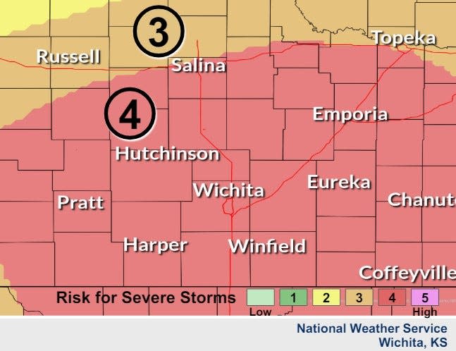
In a graphic posted to its website, the National Weather Service's Wichita office said much of the region, including Salina and Hutchinson, is part of an area that is expected to see a "moderate" risk of significant severe weather including the possibility of very large hail, damaging winds and tornados.
This moderate risk is an upgrade from a previous report Friday morning from the weather service that had the area in an "enhanced" risk.
At this time, the weather service said the confidence remains low on how many storms the area could see, the magnitude of potential storms or where specifically they could develop. It is also uncertain about the potential for any tornadoes.
The office said it does however have medium confidence in the timing of storms, saying they will likely not develop until after 5 p.m. Saturday.
What kind of weather hazards are possible Saturday?
The Wichita office said any kind of severe weather hazard is possible with storms that may develop from this predicted system.
There is "medium" confidence that very large hail, including baseball size or larger, damaging winds and tornadoes will be possible with the stronger storms.
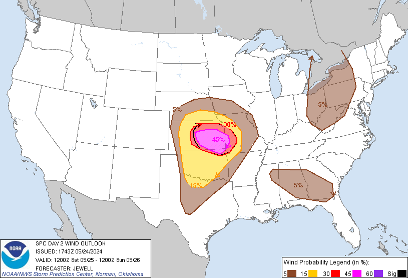
Maps on the website of the National Weather Service's Storm Prediction Center indicate that an area including Salina and Hutchinson have a 45% chance of seeing winds of near 75 mph or higher within 25 miles of any given point.
This area is also included in an area that has a 30% chance of hail 2-inches or larger in diameter.
Finally, forecasts show that much of central Kansas also has a 10% or higher chance to see a tornado touchdown within that same 25 miles.
This article originally appeared on Salina Journal: Salina, Hutchinson have 'moderate' risk of severe weather Saturday

