Point of convergence: Tracking the Tallahassee tornadoes' havoc in maps, words and photos
Two tornadoes that tore through the urban core of Tallahassee on May 10 converged at the Capital City Country Club to continue their miles long march of destruction.
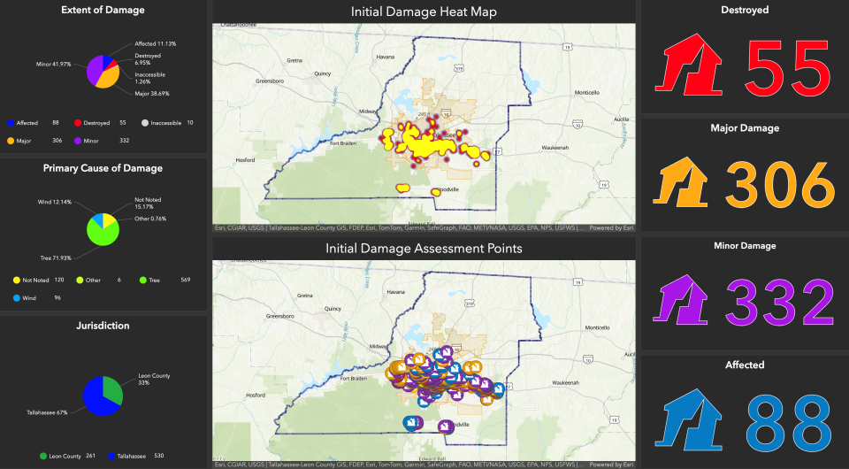
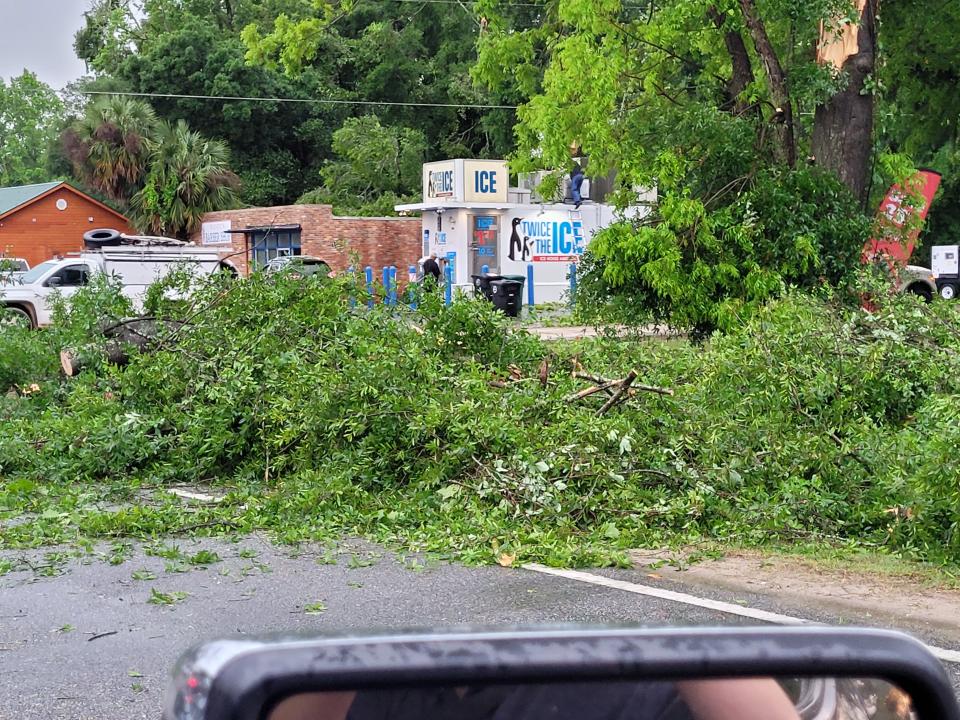
That was among the discoveries after National Weather Service surveyors confirmed that a trio of twisters were behind what many are saying is the worst damage to the capital city since Hurricane Kate.
The storms packed estimated peak wind gusts of 115 mph and the trail of uprooted trees and damaged homes and businesses enabled surveyors to map out the three tornadoes' rare, 20-minute tour of terror through Florida's capital county.
Here are the paths of the windstorms as told through the accounts of National Weather Service surveyors, as well as links, photos and video from our readers and journalists.
Tornado #1: From TCC to FSU before ravaging Railroad Square, crashing into Cascades and messing up Myers Park
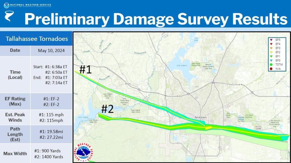
Rating: EF-2 (Significant tornado with 111-135 mph winds)
Estimated Peak Wind: 115 mph
Path Length: 19.58 miles
Path Width: 900 yards
Start: 6:38 a.m. in Greensboro in Gadsden Country
End: 7:03 a.m. in west Indian Head Acres
"The tornado touched down at approximated 6:38 a.m. near Spooner Road in eastern Gadsden County, initially damaging an old barn or farm building. The tornado track southeastward, snapping and uprooting trees through the remainder of Gadsden County before crossing the Ocholochnee River and entering western Leon County just southwest of U.S. 90."
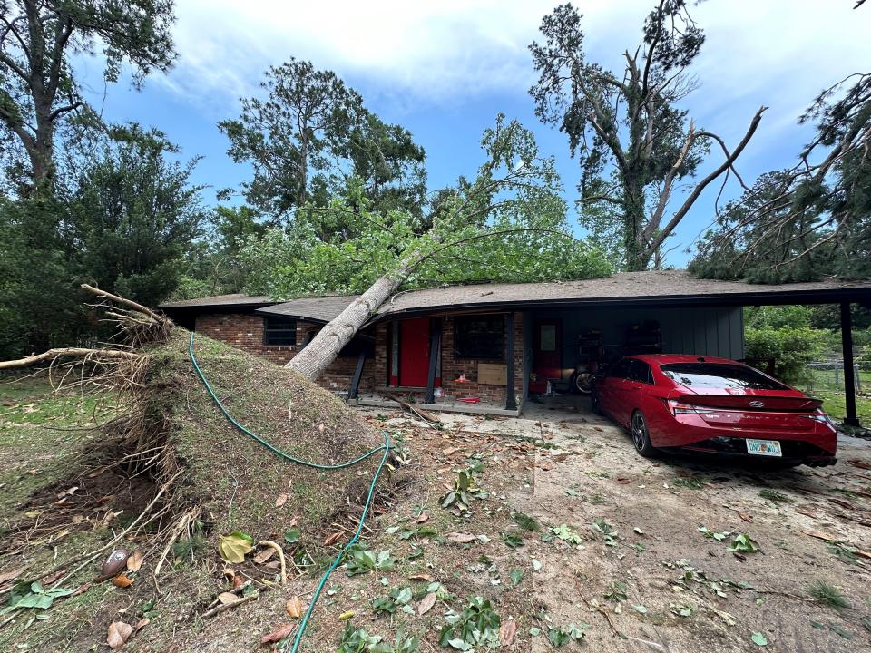
"Extensive tree damage was noted at a mobile home park on Emily Loop where several homes were damaged by falling trees. The tornado caused roof and siding damage to a hotel and shopping center near the intersection of Capital Circle Northwest and U.S. 90."
"The tornado appears to have intensified as it moved southeast after crossing Capital Circle and approaching Blountstown Highway. EF-2 damage was noted to an automotive repair building along Blountstown Highway, along with intense tree damage, with a swath of nearly every pine tree snapped at approximately 75 feet above the ground."
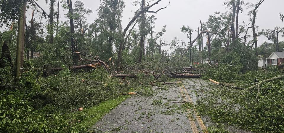
"This level of damage continued across Pat Thomas Boulevard. Significant tree damage was noted on the campuses of Lively Technical College and Tallahassee Community College before the tornado crossed Appleyard Drive. Another area of intense tree damage was noted along Cactus Street, consistent with an EF-2 rating. Numerous homes were damaged by falling trees."
"The tornado then moved through a densely populated area of single family and multi-family homes, causing widespread EF-1 tree damage. Numerous homes and businesses were damaged by falling trees as the tornado crossed Pensacola Street and approached the Florida State University Campus."
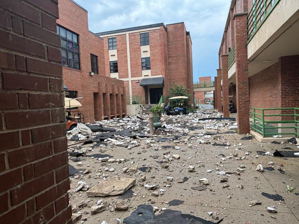
"Numerous trees were downed on the southwestern part of the campus. In addition, the tent housing the Florida State University Flying High Circus was destroyed and the outfield fence at Dick Howser Stadium was severely damaged."
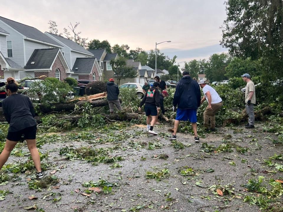
"The tornado moved along Gaines Street, causing damage to a few businesses, and causing a construction crane to collapse."
"At Railroad Square, several warehouse buildings were severely damaged, along with the roof of the railroad depot. Snapped and uprooted trees were also noted in the downtown area, just south of the State Capital Building near the state Department of Education Building."
"At this point, the tornado began to turn more southeastward as it began to interact with the nearby tornado to its south. The tornado caused damage at Cascades Park, and significant tree damage in Myers Park."
"The tornado then moved through Country Club Estates and onto the Capital City Country Club."
At this time, the track converged with that of the tornado to the south, with the tornado to the south appearing to become the dominant feature moving forward. The peak intensity EF-2 intensity of 115mph is estimated to have occurred in a couple of spots between Blountstown Highway and Cactus Street. The maximum width was approximately 900 yards."
Tornado #2: Born in Lake Talquin State Park, twister rakes FAMU before 'converging' at Capital City Country Club and battering Indianhead
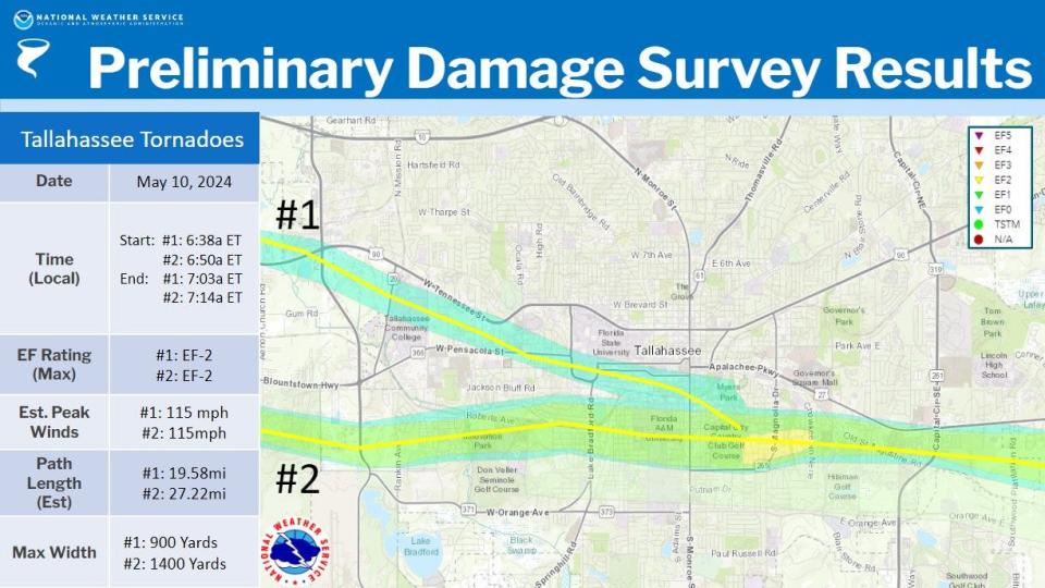
Rating: EF-2 (Significant tornado with 111-135 mph winds)
Estimated Peak Wind: 115 mph
Path Length: 27.22 miles
Path Width: 1,400 yards
Start Time: 6:50 a.m. near Fort Braden
End Location: 7:14 a.m. near Chaires Crossroads in Jefferson County
"The tornado touched down at approximately 6:50 a.m. in Lake Talquin State Park at Williams Landing, promptly producing EF-1 damage snapping numerous softwood and hardwood trees. The tornado would then continue trekking east-southeast before making a hard right and traveling due east as it passed the intersection of Blountstown Highway and Ft. Braden Trail Road, producing damage consistent with an EF-1 rating by snapping numerous hardwood and softwood trees along the way."
"The tornado would then continue east, paralleling Blountstown Highway as it then impacted Lake Talquin State Recreational Area where it would continue producing EF-1 damage by snapping trees. The tornado would then shift its trajectory to east-southeast once again, impacting many subdivisions in the Norfleet neighborhood south of Blountstown Highway snapping numerous trees across the area."
"It would then continue on its east-southeast path before traveling east once again as it reached just north of the intersection of Capital Circle SW and Orange Ave W in Tallahassee. It would then go on to impact the neighborhoods of Seminole Manor and Mabry Manor snapping many trees along the way and causing damage to Sabal Palm Elementary School."
"The tornado would then continue its eastern track impacting Florida A&M University (FAMU) producing EF-1 damage by snapping numerous trees along the way. This included roof damage to at least two university buildings. EF- 0 damage was observed a handful of times to eve's on homes and businesses as well as occasional shingle damage."
"The tornado would continue moving east toward Capital City Country Club Golf Course producing EF-1 damage by snapping numerous trees along the way and across the golf course. The tracks of both tornadoes moving through Tallahassee at this time converged at Capital City Country Club, with this tornado seemingly becoming the dominant circulation moving forward."
"As the tornado exited the golf course, very intense tree damage consistent with an EF-2 rating was observed as numerous trees were snapped at a height of around 75 feet. This most intense tree damage occurred from Country Club Dr. through the Indian Head Acres subdivisions."
"This is where the maximum estimated winds of 115mph most likely occurred. EF-1 damage would be observed through the remainder of its eastern trajectory as the tornado impacted Old St. Augustine Rd. It would go on producing EF-1 tree damage within the subdivision of Paradise Village East, Old Friends Rd, and areas along Southwood Plantation Rd before moving on to mostly forested areas north of Old St. Augustine Rd."
"The last concentrated area of EF-1 damage would be observed in neighborhoods along Louvinia Drive and WW Lee Road. The tornado would then continue east before uprooting a few trees along U.S. 27 as it crossed into Jefferson County, before dissipating around 7:14 a.m.
"The tornado reached its maximum width of 1,400 yard as it crossed Monroe St. in downtown Tallahassee and entered into the Capital City Country Club Golf Course."
Tornado #3: It crossed Lake Talquin before snapping trees and whipping through Woodville
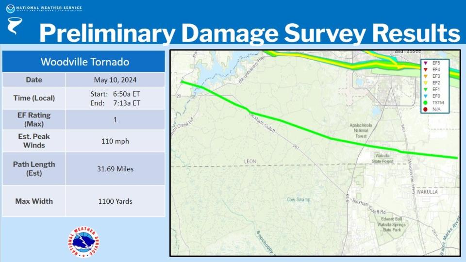
Rating: EF-1 (Moderate tornado with 86-110 mph winds)
Estimated Peak Wind: 110 mph
Path Length: 31.69 miles
Path Width: 1,100 yards
Start: 6:50 a.m. at Bloxham in Gadsden County
End: 7:13 a.m. near Natural Bridge in Leon County
"The tornado touched down near Lake Talquin Highway, just west of Lake Talquin, at approximately 6:50 a.m., promptly producing EF-0 tree damage. It then crossed Lake Talquin a few minutes later before moving ashore on the eastern shore of Lake Talquin where it produced EF-1 damage with several snapped and uprooted trees, some of which fell on two cars and a couple of houses."
"The tornado would then continue heading generally east-southeast with EF-1 damage across Blountstown Hwy and along and just south of Bloxham Cutoff Road before heading more east across Apalachicola National Forest, where downed and snapped trees were noted along some of the National Forest Roads."
"The tornado then crossed Springhill Road near the Trout Pond GF&A Trailhead, producing high-end EF-1 damage as it did so."
"The tornado then continued generally east-southeast towards US-319 near Oak Ridge Road W, continuing to produce high-end EF-1 damage. The tornado continued along Oak Ridge Road, producing EF-1 damage with several downed and snapped trees noted along the road."
"Another cluster of high- end EF-1 damage was noted on the west side of Woodville Hwy near Oak Ridge Road E. The tornado passed just north of Woodville Middle School, with numerous downed and snapped trees noted between Oak Ridge Rd E and Natural Bridge Road."
"The tornado crossed over Taff Road, where it continued to produce high-end EF-1 damage before moving over forest and farmland that was inaccessible to the survey team. Another cluster of snapped trees were noted along Old Plank Road, where the tornado was likely ongoing before lifting just east of Old Plank Road at approximately 7:13 a.m. The maximum width was around 1,100 yards along Celia Road, west of Woodville."
This article originally appeared on Tallahassee Democrat: Maps show Tallahassee tornadoes path of destruction, point of convergence

