Tornado updates: After unprecedented punch, region braces for new severe weather threat
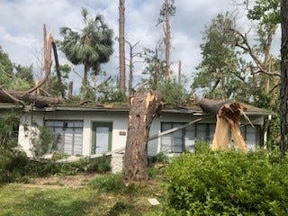
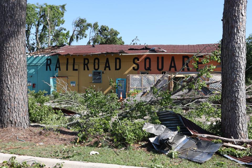
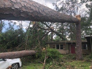
Recovery efforts in Tallahassee continued Sunday, two days after at least two tornadoes and 100-mph straight line winds ripped through the city, heavily damaging and destroying homes and businesses, blocking roads and driveways with debris and plunging much of the city into darkness.
On Saturday night, the city announced it had reached its goal of restoring power to 75% of its more than 126,000 customers. And while the city hopes to have 90% of customers restored by Sunday night, residents in badly hit areas, where power lines, poles and transformers were left a twisted wreck, braced for the possibility of a longer wait.
The National Weather Service confirmed Saturday that two EF-2 tornadoes touched down in eastern Gadsden and western Leon counties before moving into Tallahassee. NWS survey crews are going out again today determine whether a third tornado hit southern Leon County. The storms claimed the life of 47-year-old woman, who was killed when a tree hit her home off Aenon Church Road.
Here are the latest reports from our journalists on the ground:
Forecasters bump up risk for Monday severe weather threat for North Florida; sandbag sites open after Flood Watch
No one wants to hear this.
"Forecast confidence has increased regarding the incoming severe weather and flooding threat beginning Monday lasting through Tuesday," the National Weather Service in Tallahassee wrote in a late afternoon briefing warning of multiple rounds of severe weather over the next two days.
"Increasing confidence regarding some stronger storms within the forecast area tomorrow has led to an increase to a Slight Risk (2/5) for portions of the FL Panhandle, SE AL, and the majority of our SW GA counties," the forecast continues. noting that "damaging wind and tornadoes appear possible, with a risk of significant wind gusts (greater than 74 mph." On Tuesday there is a Marginal Risk (1/5) for severe weather.
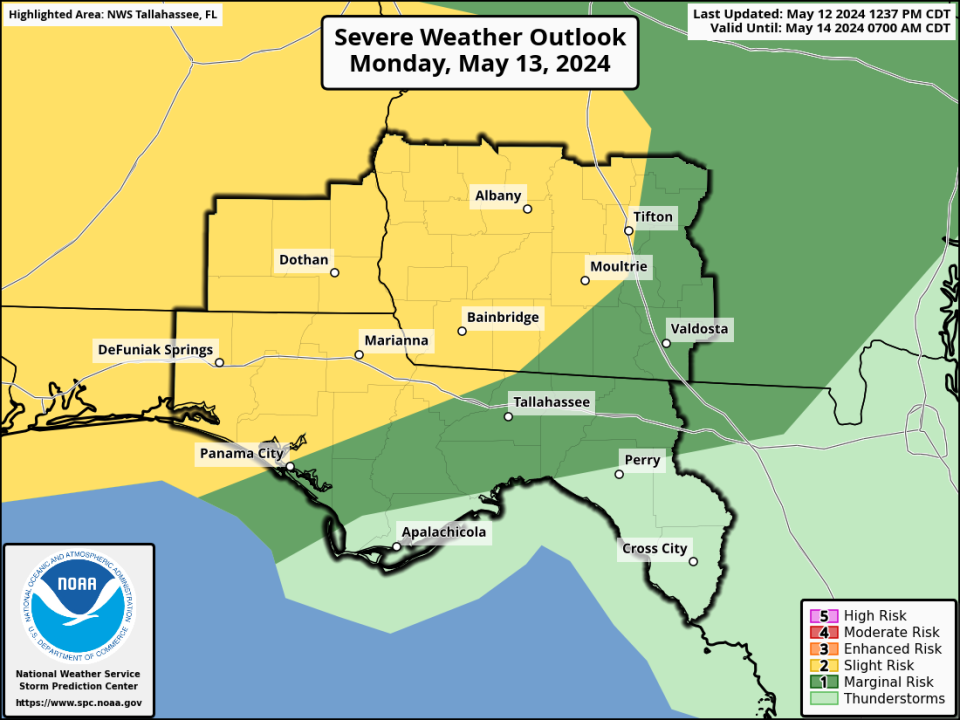
There is also a Marginal Risk (1/4) remains for flooding in the Big Bend, which could see 2-5 inches with isolated higher amounts possible.
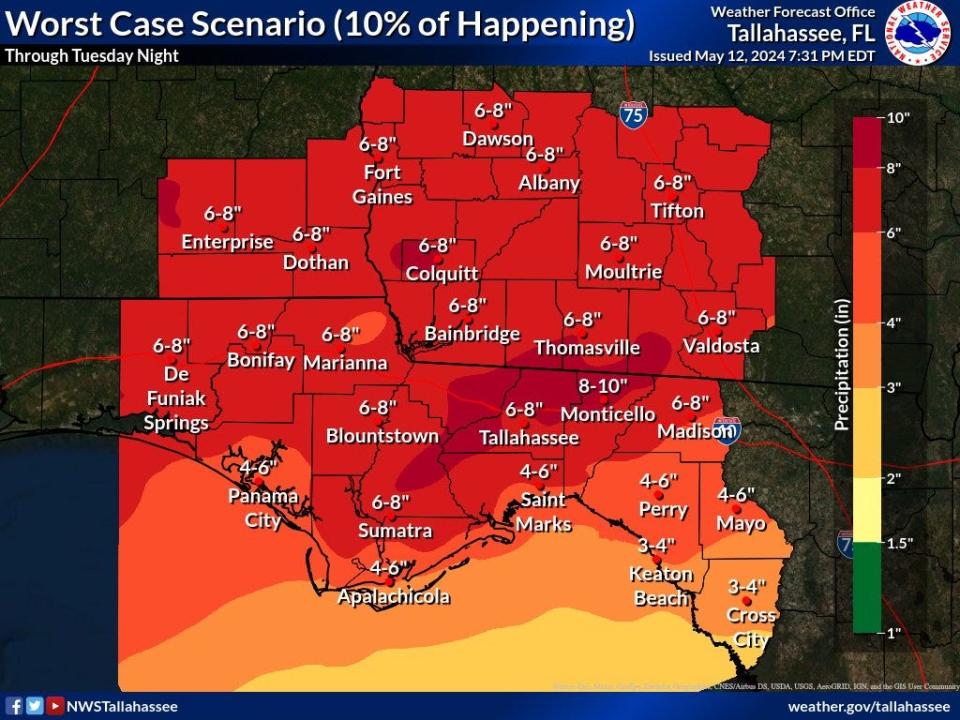
At about 7:30 p.m., a flood watch was issued for Tallahassee and much of north Florida and south Georgia. The weather service took the rare step of providing a "worst case scenario," which has a 10% chance of happening. In such a scenario, the area could see 6 to 8 inches of rain.
"We're not saying that this much rain will fall everywhere, just that there is the potential for a few locations to pick up this much rain," the National Weather Service wrote on X. "This is to show the potential for higher amounts."
Beginning Monday, May 13, at 9 a.m., sandbags will be available to the public at the following city of Tallahassee and Leon County locations:
Leon County's Northeast Branch Library, 5513 Thomasville Road
Apalachee Regional Park (Solid Waste Management Facility), 7550 Apalachee Parkway
Fred George Park, 3043 Capital Circle NW
At the intersection of Oak Ridge Road at Ranchero Road
Ft. Braden Community Park, 15000 Blountstown Highway
City to open 2 sandbag locations tomorrow, 5/13, starting at 9am.
Jack McLean Park (700 Paul Russell Road)
Tom Brown Park (501 Easterwood Drive)
Forecasters left open the severity risk could increase in future forecasts.
As for timing: "A round of storms with severe storms possible could occur as early as tomorrow morning into the early afternoon across the western half of the region, spreading eastward in the afternoon hours. This will be followed by another round of storms in the late afternoon through the evening, and some storms may also be severe. Additionally, more storms are expected Tuesday afternoon into the evening with some severe storms possible as well."
National Weather Service confirms third tornado in southern Leon County
The National Weather Service has confirmed a third tornado strike. Rated an EF-1, the twister crossed southern Leon County impacting Woodville and surrounding areas.
Such tornadoes packing winds of 86 to110 mph. They are considered "moderate tornadoes" that peels tiles off roofs, overturns mobile homes and pushes vehicles off the road.
Here is how NWS traced the trail of destruction.
"The tornado touched down near Lake Talquin Hwy, just west of Lake Talquin, at approximately 6:50AM ET, promptly producing EF-0 tree damage. It then crossed Lake Talquin a few minutes later before moving ashore on the eastern shore of Lake Talquin where it produced EF-1 damage with several snapped and uprooted trees, some of which fell on two cars and a couple of houses.
"The tornado would then continue heading generally east-southeast with EF-1 damage across Blountstown Hwy and along and just south of Bloxham Cutoff Road before heading more east across Apalachicola National Forest, where downed and snapped trees were noted along some of the National Forest Roads. The tornado then crossed Springhill Road near the Trout Pond GF&A Trailhead, producing high-end EF-1 damage as it did so.
"The tornado then continued generally east-southeast towards US-319 near Oak Ridge Road W, continuing to produce high-end EF-1 damage. The tornado continued along Oak Ridge Road, producing EF-1 damage with several downed and snapped trees noted along the road.
"Another cluster of high- end EF-1 damage was noted on the west side of Woodville Hwy near Oak Ridge Road E. The tornado passed just north of Woodville Middle School, with numerous downed and snapped trees noted between Oak Ridge Rd E and Natural Bridge Road.
"The tornado crossed over Taff Road, where it continued to produce high-end EF- 1 damage before moving over forest and farmland that was inaccessible to the survey team. Another cluster of snapped trees were noted along Old Plank Road, where the tornado was likely ongoing before lifting just east of Old Plank Road at approximately 7:13AM EDT. The maximum width was around 1100 yards along Celia Road, west of Woodville."
Leon County schools mostly open, but buses won't be rolling and start times are delayed
All Leon County public schools will be open Monday except SAIL High School and Sabal Palm Elementary School.
in an evening Facebook announcement, Superintendent Rocky Hanna said power has been restored at almost all schools, though there will be some changes in school day routines for students and parents.
School Operations Update
Posted by Leon County Schools on Sunday, May 12, 2024
“Tomorrow we're going to make some adjustments but we are going to have our schools open that have power and the capacity to accept students,” Hanna said.
He also said school buses will not operate because they don't have the clearance to avoid road hazards such as downed trees. Student absences will be excused for hardships and all school start times will be delayed by 30 minutes.
Click here for the full story.
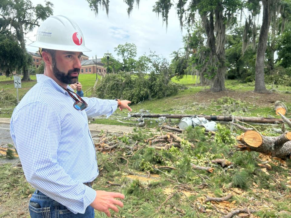
Manager on front lines of power restoration shares update on around-the-clock effort, overtaxed outage map
Mike Crow, the City of Tallahassee's assistant general manager for power delivery, said the biggest challenge in repairing the electric grid was navigating the debris-dumped terrain. It makes it hard, he said, to even get an assessment of what workers need to get started on a repair.
"It's something we haven't seen at this level in the past," Crow said. The damage around town reminded him of the ravages of 2018's Hurricane Michael in the rural counties west of Tallahassee. "This essentially looks like a Hurricane Michael but in an urban environment."
In a video update posted on X, Mayor John Dailey said they are making progress but "we have a long way to go."
Sunday Afternoon Update pic.twitter.com/lAXCu6AH6F
— Mayor John Dailey (@MayorOfTLH) May 12, 2024
"When you go down and look at the communities that were right in the path of the tornadoes, we are not just fixing the grid, we have to rebuild the grid," he said, adding the city is on pace to have 90 percent of customers back online with power.
Crow also had a message for people still in the dark who are worried their home has been missed or who are frustrated with the city's outage map, which officials say has been lagging and not keeping up with the crews' progress.
City of Tallahassee: Broken utility pole count breaks records
The city's 4:42 p.m. Sunday update to text message subscribers said: "Extensive damage caused by the tornadoes has increased, with the broken utility pole count now at 399 confirmed, which exceeds Hurricanes Hermine, Irma and Michael combined."
It added: "Progress was made overnight and throughout today on power restoration, including to Leon County Schools. Electric service has been restored or is currently in the process of being restored by tonight to all Leon County Schools except for SAIL High School and Sabal Palm Elementary, which are in areas hardest hit by tornadoes that caused massive damage."
TCC to remain closed Monday
Power had not been restored to the campus of Tallahassee Community College by Sunday afternoon, and administrators have decided to remain closed on Monday, the school's website said.
"Utility crews are working on the circuit, but it is having to be rebuilt due to the level of destruction in the area," the site said. "... We ask that all nonessential personnel avoid main campus until the all-clear has been given."
The power outage "also affects Information Technology services coming from the main campus. Gadsden Center, Ghazvini Center for Healthcare Education, Wakulla Center, and Wakulla Environmental Institute will remain closed. College services are suspended at the Center for Innovation. Florida Public Safety Institute will be open for normal operations."
FSU back to normal on Monday
In a Facebook post, Florida State University said it will "resume normal operations Monday following Friday’s storm."
Campuses in Tallahassee "will resume normal operations Monday, May 13, 2024, beginning at 12:01 a.m. All Summer Semester Session A, C, and F courses will meet as scheduled and all university employees should report to work Monday as scheduled. All students and instructors should continue to follow the first class meeting attendance policies."
The rest of the post is here.
FAMU to hold virtual 'town hall' on campus recovery and operations
Florida A&M University will hold a virtual town hall 6 p.m. Sunday "to share details of the recovery and operations following Friday’s violent storm," a press release said.
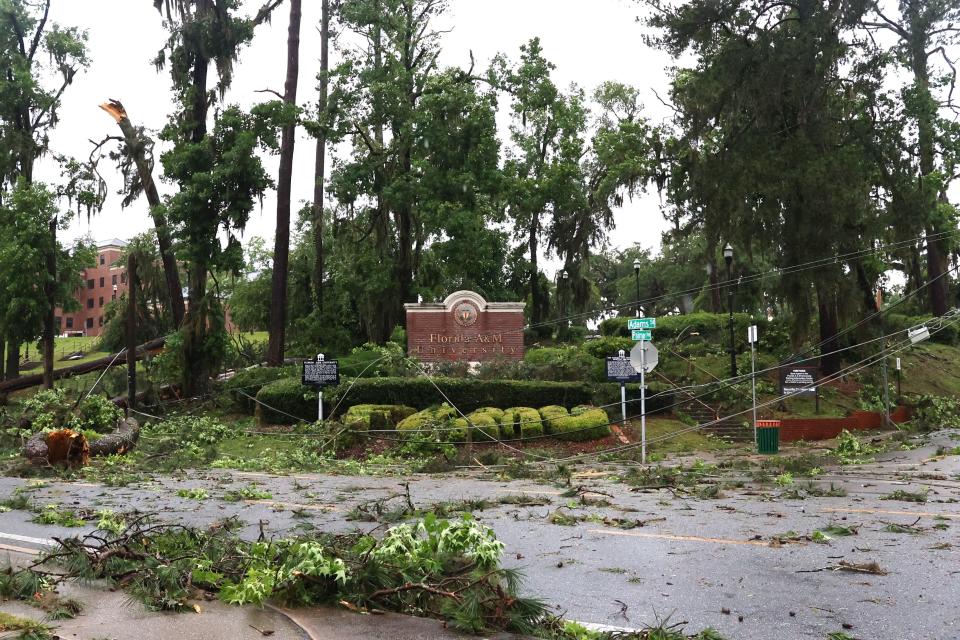
"President Larry Robinson, members of the senior leadership team and other administrators will provide updates for faculty, students and staff ahead of the work week," it added.
Monday, May 13 marks the start of Summer A and C sessions at FAMU. Classes will be conducted via remote May 13-17 while the campus cleanup is underway. Students are advised to contact their course instructors for more details.
To join, go to: https://famu.zoom.us/j/94098891091?pwd=TWhTZ241N0N0R2xEZW1YdUx0QUNwUT09
Some local public schools may be closed Monday
Leon County schools is planning to open schools on a case-by-case basis based on whether they have power and damage.
They have scheduled a 5 p.m. announcement live on Facebook.
"Crews are working as hard as they possibly can to get the power restored, but there is a lot to overcome right now," Superintendent Rocky Hanna said in a video from Sabal Palm Elementary, where power lines are still down.
He said an official determination will come at 4 p.m. At the moment, the following schools DO NOT have power:
Lincoln
Rickards
Godby
Sail
Fairview
Nims
Apalachee
Hartsfield
Sabal Palm
Leon
Lively
Sealey
Ace
Wesson
Howell, Bloxham, IT, both bus compounds.
Update while touring Sabal Palm Elementary. We will let you know the status of individual schools after 4:00 pm today. At the moment, the following schools DO NOT have power: LincolnRickardsGodbySailFairview NimsApalacheeHartsfieldSabal Palm Leon Lively SealeyAce Wesson Howell, Bloxham, IT, both bus compounds.
Posted by Leon County Schools on Sunday, May 12, 2024
County to begin curbside debris collection by Friday
Leon County will begin collecting curbside "vegetative disaster debris" for the unincorporated area of the county by Friday, a news release said, with "a second pass in late May or early June." Collection will occur on both public and private roads in the unincorporated area.
Here's more from the release:
All debris for collection should be placed curbside between the sidewalk or property line and the curb.
Keep vegetative debris loose and unbagged at the curb.
Only vegetative disaster storm debris will be collected.
Be careful and safe when moving large, bulky storm-related debris to the curb.
Debris removal trucks will not pick up household garbage; Waste Pro will continue to collect trash, recycling, and smaller yard debris as usual on their normally scheduled days.
Do not stack or lean debris against sprinkler heads, meters, poles, trees, backflows, and other structures.
Leon County also will offer free-of-charge yard and debris drop-off for all Leon County citizens at both the Solid Waste Management Facility and all the Rural Waste Service Centers until further notice. The Leon County Solid Waste Management Facility, located at 7550 Apalachee Parkway, will be open to all County residents from Monday to Friday from 8 a.m. to 5 p.m.
The Leon County Rural Waste Service Centers will also remain open every day from 9 a.m.-5 p.m. at the following locations:
Woodville, 549 Henry Jones Rd.
Fort Braden, 2485 E. Joe Thomas Rd.
Miccosukee, 13051 Miccosukee Rd.
For the latest updates and emergency information, visit the County’s Emergency Information Portal at LeonCountyFL.gov/ei or call (850) 606-1500.
City of Tallahassee says crews 'working non-stop'
In its 11:40 a.m. Sunday update to text message subscribers, the city said work crews "have identified 333 broken poles (expected to grow to 500) and 91 damaged transformers as of now."
It also said "circuits in the path of the tornadoes are being fully rebuilt. Additional mutual aid crews arrived yesterday, adding an additional 100 crew members. Approximately 300 mutual aid personnel are working alongside City crews as of this morning, and additional crews are arriving today."
The city's power outage map, however, does not align with what the state's Public Service Commission is reporting.
As of their respective noon Sunday updates, the city reports 435 outage orders affecting 43,351 customers, or 34% out. The PSC shows only 28,554 customers still without power, or 23% of the total base.
City officials have said the map is not keeping up with the rapid progress that linemen are making in powering up the capital. Approximately 300 mutual aid personnel are working alongside city crews, which has effectively quadrupled their workforce, city officials have said.
The state's Hope Bus at Bragg Stadium Sunday
The Florida Department of Children and Families' Hope Bus is now stationed at Bragg Memorial Stadium, 1500 Wahnish Way in Tallahassee, till 5 p.m. Sunday, the department's spokesperson told the Democrat.
Those in need of supplies after Friday's storms can get tarps, water, snacks and wipes, among other items.
'Never seen damage to this scale': Tornado's path of destruction dwarfs that of Hurricane Michael
Many have said the tornadoes that brought the highest winds to Tallahassee in recorded history left a trail of destruction that rivals almost any hurricane the capital city has endured.
Now we have some numbers that bear that out.
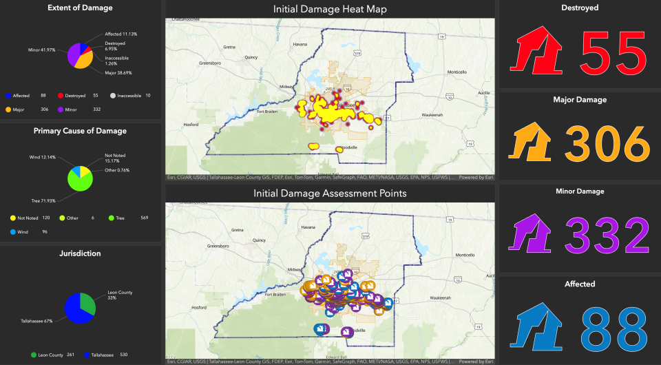
Leon County spokesperson Matt Cavell in consultation with Kevin Peters, Leon County's Emergency Management Director, told the Democrat Sunday morning that 46 buildings were destroyed by the storms that lashed the city and county with 100 mph winds.
"To put it in perspective, that’s twice as many destroyed structures that we had for Hurricane Michael," Cavell said, noting that 25 structures were destroyed by what many consider the region's Category 5 "storm of the century."
"We are nearly twice that number and still getting into the hardest hit areas to continue the damage assessment today," Cavell said.
County officials say there have been 550 homes, businesses and buildings damaged by trees in some way, with 300 reporting major damage from either trees or vicious straight-line winds. After Hurricane Michael, 243 homes and buildings sustained major damage.
"In all my years of disaster response, I've never seen damage to this scale anywhere, let alone in my hometown. Now we have to be patient and support our first responders as we rebuild and recover," Peters said.
And county officials expect the numbers to keep growing as they finally break through the debris and make it into areas that endured the worst blows.
"If you can’t get into the neighborhood you know you are gonna have significant damage inside the neighborhood," Cavell said.
More storms, heavy rain, coming to Tallahassee as tornado recovery continues
Another severe weather system is in the forecast for Tallahassee, bringing the possibility of heavy rain as local residents continue to deal with trees in their homes and holes in their roofs.
The National Weather Service in Tallahassee said a line of showers and storms will move across the area Tuesday, though some rain could arrive as early as Monday night.
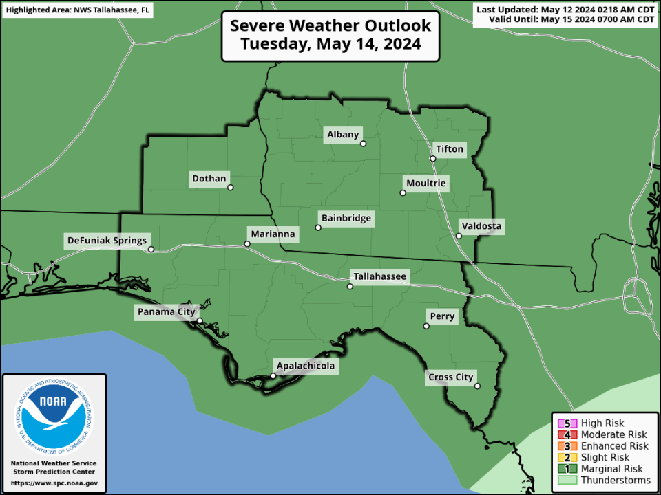
“All hazard types, strong gusty winds, tornadoes and hail are possible along with heavy rainfall potentially leading to flash flooding,” the Weather Service said.
The Storm Prediction Center has the entire Tallahassee area under a marginal risk (1 on a scale of 1-5) for severe weather. The Weather Prediction Center assigned a slight risk (2 on a scale of 1-4) for excessive rainfall Monday night and Tuesday.
“We're looking at not just the threat for severe weather but also the threat of heavy rainfall,” said NWS meteorologist Israel Gonzalez. “It could be pretty messy and active on Tuesday. Unfortunately, it looks like it could affect some people who are still recovering from Friday’s storms.”
National Weather Service could confirm third Tallahassee tornado today
The National Weather Service in Tallahassee, which confirmed on Saturday that two EF-2 tornadoes hit the capital city on Friday, could confirm a third tornado later today.
NWS survey teams are going out this morning to southern Leon County, where a third rotating storm moved through Friday morning at the same time as the two confirmed tornadoes.
“We looked on radar and that was one of three circulations that we saw that looked like it was accompanied by the debris signature,” said Israel Gonzalez, NWS meteorologist. “We have reasonably high enough confidence to suspect that a tornado impacted that area.”
Gonzalez said one NWS team will investigate damage from the Woodville area westward in Tallahassee. If a tornado is confirmed, the Weather Service will assign a rating based on wind speeds.
EF-2 tornadoes have wind speeds of 111 to 135 mph on the Enhanced Fujita Scale.
A second survey team is going to the Dothan, Alabama, area today to investigate another possible twister that caused minor damage there.
More than 30,000 electric customers in Leon, surrounding counties still without power
Nearly 30,000 people in Leon County remained without power as of Sunday morning, according to the state of Florida's most recent outage report, published at 6 a.m.
Power outages were affecting 29,715 city of Tallahassee electric customers, or 24% of its accounts, and 4,351 Talquin Electric Cooperative customers, or 17% of its accounts.
The city said Saturday that it had restored power to 75% of customers as of 7:40 p.m. The day before, the city pledged to reach that milestone by 8 p.m. Saturday.
"Crews will continue working through the night to reach 90% by Sunday night," the city said in a Saturday text message to customers.
Power outages were down to the hundreds in surrounding counties, according to state figures. There were 770 customers without power in Wakulla County, 364 in Gadsden County and 163 in Jefferson County.
Contact Jeff Burlew at jburlew@tallahassee.com or 850-599-2180.
This article originally appeared on Tallahassee Democrat: Tallahassee tornado updates: 30,000 still out of power; cleanup continues

