How windy is it? Small fire starts near Horsetooth Rock; power out for thousands
Editor's note: This story is no longer being updated. You can read Monday's recap of the weekend storm, including an update on power outages and a look at top wind gusts, here.
With winds of up to 100 mph expected in Colorado on Saturday, Xcel Energy pre-emptively shut off power to some customers in northwest Fort Collins, Laporte, Larimer County and beyond due to fire danger.
A planned outage starting around 3 p.m. Saturday was expected to cut power to places in northwest Fort Collins and Laporte, Poudre Fire Authority posted on its Facebook page. The outage could extend through at least noon Sunday, PFA said.
Winds are picking up as the day passes, and closures are being announced. Here are updates from the storm:
150,000 Xcel customers lost power
Xcel Energy says more than 150,000 of its customers lost power over the weekend due to the wind storm, with 55,000 affected by the pre-emptive de-energizing of lines on Saturday and around 100,000 losing power due to wind damage.
In a string of posts on X.com late Sunday morning, Xcel said crews are out assessing damage and that the work to restore power to everyone will begin after winds have died down. Some people may not have power restored until Monday or later, Xcel said.
Crews must visually inspect lines before they can turn power back on.
The outage map will list estimated times of restoration of power when possible, Xcel said. Find the map here.
Poudre Valley REA on Sunday morning posted multiple updates on X.com about its progress restoring power.
Overland Trail reopens, along with Interstate 25
North Interstate 25 from Wellington to the Wyoming state line is open again after it was closed down Saturday afternoon, the Larimer County Sheriff's Office posted on Facebook.
And Overland Trail is reopen from Bingham Hill Road to Lions Open Space after tree debris affected the road, the Larimer County Sheriff's Office reported about 10:45 a.m. Sunday.
High wind warning canceled for Fort Collins
The National Weather Service in Boulder canceled the high wind warning for the Boulder-Fort Collins corridor, as of about 9:45 a.m. Sunday.
It remains in effect for much of Colorado, including parts of Weld and Larimer counties.
"Still blasting up to 80 mph in wind prone areas of the foothills, and 55-65 mph over the northeast (Colorado) plains," the NWS posted on X.com.
A red flag warning, which warns of fire danger due to conditions that cause fire to spread quickly, is in effect until 6 p.m.
More good news, the highest winds have decreased even in the Boulder area. The High Wind Warning has been cancelled for the Boulder - Fort Collins Corridor.
Still blasting up to 80 mph in wind prone areas of the foothills, and 55-65 mph over the northeast CO plains. #COwx pic.twitter.com/e1fO0kcZfv— NWS Boulder (@NWSBoulder) April 7, 2024
Today's forecast for Fort Collins
A high wind warning remains in effect through noon Sunday for the Fort Collins area, along with a red flag warning that expires at 6 p.m.
Today, expect blowing dust, mainly before noon, with winds 30 to 36 mph gusting to 65 mph. It'll be partly sunny, with a high near 54.
Tonight, expect more blowing dust before 9 p.m., with winds of 23 to 28 mph decreasing to 9 to 14 mph after midnight. Gusts could reach 47 mph. It'll be partly cloudy with a low around 29.
When Monday gets here, it'll still be breezy, according to the forecast, but much less than Sunday: Winds 8 to 15 mph with gusts as high as 24 mph. The National Weather Service says to expect mostly sunny skies and a high near 55.
Existing High Wind Warnings....Front Range Mountains, Foothills, and west of I-25 til Noon today, Northeast plains til 6 pm. #COwx pic.twitter.com/Wo1FjK7dJx
— NWS Boulder (@NWSBoulder) April 7, 2024
Number of homes without power increases
Nearly 20,000 people in Northern Colorado areas of Fort Collins, Loveland and Greeley were without power Sunday morning, according to an analysis of outage maps across three different power providers.
Xcel Energy's outage map showed about 7,100 people without power.
Poudre Valley Rural Electric Association showed more than 12,500 without power.
Fort Collins Utilities reported no outages.
Xcel said Saturday that its pre-emptive de-energizing of power lines would last until noon Sunday or even later because its workers need to physically inspect lines before restoring power.
PVREA said it didn't have an estimated time for when power would be restored but crews are out now working on it.
Here’s an example of what crews are facing. This is a photo of the transmission line that brings electricity to our mountain areas. We have crews dispatched with materials. This pole has to be replaced before we can restore power to the mountain areas. More to come. pic.twitter.com/bZ9HOPpCt8
— Poudre Valley REA (@PoudreValleyREA) April 7, 2024
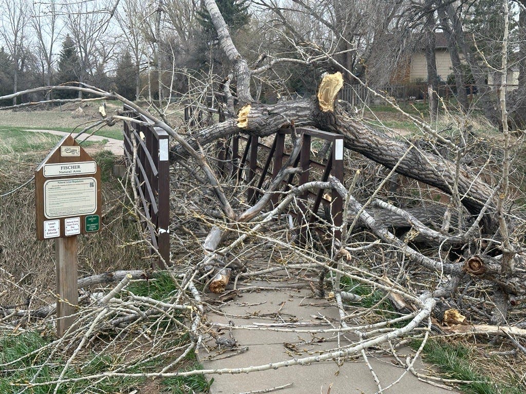
1-acre fire broke out near Horsetooth Rock
Poudre Fire Authority responded to a wildland fire near Horsetooth Rock just after 11 p.m. Saturday, it posted on Facebook.
It was located off Tower Access Road and was mopped up as of about 6 a.m. Sunday, PFA said. Firefighters estimated the fire to be about one acre.
Volunteer firefighters who live in the area said they observed multiple spot fires close to each other, so a second alarm was called. Firefighters had to cut through downed tree debris and navigate snow drifts to access the fire, PFA said.
The cause of the fire is not known because power lines were reported to be de-energized.
Fire burns between Estes Park and Lyons
A fire dubbed the Moose Fire is burning less than an acre in National Forest Service land between Estes Park and Lyons.
The location is at U.S. Highway 36 and Big Meadows Road, according to the Arapahoe and Roosevelt National Forest.
A Sunday morning update said crews worked to cool internal hot spots once the wind slowed down.
Winds expected to gradually decrease Sunday
The worst has passed for Fort Collins and Denver, and winds will gradually decrease Sunday afternoon, the National Weather Service in Boulder said early Saturday in a post on X.com.
But it's still windy "immediately adjacent" to the foothills and on the northeast plains, the post said.
"For the I-25 corridor and near the foothills, we've reached the more typical mountain wave portion of this event, where some areas will blast, while others are nearly calm," the NWS said.
An animated map shows how wind speeds are expected to progress Sunday:
Still very windy in and immediately adjacent to the foothills, and also over the northeast plains through this morning, but gradually decreasing today. Worst has passed for Denver - Ft Collins I-25 Corridor.
Expected wind gusts through the rest of today⬇️ #COwx pic.twitter.com/J3TZrIGhAJ— NWS Boulder (@NWSBoulder) April 7, 2024
Xcel Energy releases live map of shutdown areas
When Xcel announced on social media that it planned shutoffs of power Saturday afternoon, it was met with a flurry of responses asking the utility for a map showing where the planned shutoffs were going to be. Xcel said it didn't have one.
Late Saturday, it released one. Magenta brushstrokes show shutoff areas west and northwest of Fort Collins, west of Loveland, in and west of Boulder, and to the east of Boulder.
The map can be found here.
Wind speeds as darkness settled Saturday night
Here are the highest wind speeds reported as of 9 p.m. Saturday to the National Weather Service in Boulder's storm report:
Breckenridge: 91 mph, 83 mph
Buckhorn, Larimer County: 91 mph, 85 mph
Near Rocky Flats: 89 mph, 87 mph, 85 mph, 83 mph
Near Sterling: 84 mph
Interstate 35 and Buckeye Road: 82 mph, 81 mph
Niwot Ridge: 81 mph
Crisman, Boulder County: 80 mph
Outage maps say 10,000 in Northern Colorado without power
Electricity is out for more than 10,000 customers in the Fort Collins, Loveland, Greeley and surrounding areas as of 9 p.m. Saturday, according to outage maps from Xcel Energy and Poudre Valley REA.
Xcel's map showed more than 7,500 customers without power.
PRVREA's map showed around 3,000 customers without power.
Fort Collins Utilities is reporting no outages.
Overland Trail closed due to road debris
Overland Trail in Fort Collins is closed down from Bingham Hill Road north to Lions Open Space because of debris on the road, the Larimer County Sheriff's Office reported around 5:30 p.m. Saturday.
North Interstate 25 in Colorado closed to all vehicles
Both directions of I-25 between Wellington and the state line with Wyoming are closed to all vehicles, the Colorado Department of Transportation posted just before 4 p.m. Saturday on X.com.
Outages affecting thousands in Fort Collins, Loveland area
A map of power outages on Xcel Energy's website around 4 p.m. shows about 5,000 customers affected in the Fort Collins and Loveland area.
Around 300 customers are without power through Poudre Valley REA, according to their map.
No new outages were active within Fort Collins Utilities on Saturday, its map showed.
Some wind speeds so far
An 85-mph wind gust was reported north of Fort Collins in an area known as Buckeye. That's located north of Fort Collins between Interstate 25 and U.S. Highway 287. Earlier, the same station reported a gust of 75 mph.
As of 3:30 p.m. Saturday, here are some other wind speeds of note reported to the National Weather Service:
Timnath: 71 mph
Near Virginia Dale: 69 mph
Interstate 25 and Buckeye Road: 66 mph
Christman Air Field, Laporte: 63 mph
Near Copper Mountain: 83 mph
Near Rocky Flats: 87 mph
Near Boulder: 81 mph
Near Georgetown: 74 mph
Near Sterling: 73 mph
North Interstate 25 is closed to some vehicles
Interstate 25 from Wellington to Wyoming is closed to high-profile vehicles, the Colorado State Patrol announced on its CSP Larimer social media account on X.com.
The closure began at 1:30 p.m. Saturday.
In southern Wyoming, westbound Interstate 80 is closed starting in Cheyenne, according to the Wyoming Department of Transportation's WYODOT1 account on X.com.
Xcel plans outages, including in Larimer County
The Xcel outage includes the Colorado State University Foothills Campus, a university social media account announced Saturday morning.
Power to the west Fort Collins campus will be turned off Saturday afternoon, a message from the CSU Police & Safety social media account on X.com posted.
Xcel Energy announced late Saturday morning that it was notifying some customers in Larimer, Boulder, Gilpin, Jefferson, Broomfield and Douglas counties that power would be cut Saturday afternoon into Sunday.
It affects about 55,000 customers total, primarily in Boulder County, but also in "small sections" of the other counties, it noted on its website.
"Safety of our communities, customers and crews is our top priority. Due to the exceptionally high winds and the high risk of wind-driven wildfires, we will be shutting off power to a limited set of customers," the utility posted on X.com.
"This is an action to decrease the risk of wildfires, though outages may persist beyond the heightened wind and fire risks," Xcel's post said.
Xcel Energy had warned late Friday it might need to cut power to some lines to deal with high winds.
"With this weekend's extremely high winds created elevated wildfire risk, we may need to temporarily de-energize powerline, turning of electrical service to customers in certain areas of Boulder, Gilpin and Jefferson counties," the utility provider said on the X.com social media platform. "Turning off customers' power is not something we take lightly, but intended to decrease the risk of wildfire."
Xcel said it would attempt to contact affected customers directly.
Outages will last until at least noon Sunday and likely longer because crews have to physically inspect the power lines, Xcel said.
To prepare for an outage, Xcel suggests gathering a kit with:
Flashlights
Batteries
Portable charger
A phone that does not require electricity
Non-electric alarm clock
Bottled water and non-perishable food
Manual can opener
First aid kit
Extension cords for partial outages
Manufacturer's instructions on how to manually open power-operated doors
How to track and report power outages in Larimer County
While Fort Collins Utilities provides power to much of Fort Collins city limits, it doesn't cover the entire area.
Xcel also provides electricity in the Fort Collins area.
Outside of Fort Collins, Poudre Valley Rural Electric Association provides power to much of Larimer County.
You can track outages by Xcel at www.outagemap-xcelenergy.com/outagemap.
You can track outages for Fort Collins Utilities here. The vast majority of power lines in Fort Collins are buried underground, but the lines bringing power from Platte River Power Authority to the city are not.
Track outages within Poudre Valley REA here.
To report unplanned power outages, use these phone numbers:
Estes Park Power and Communications: 970-586-5335
Fort Collins Utilities: 970-221-6710
Longmont Power and Communications: 303-776-0011
Loveland Water and Power: 970-962-3000
Xcel Energy: 800-895-4999
Poudre Valley REA: 800-432-1012
What to expect with wind Saturday and Sunday
"Winds are just beginning to pick up in/near the foothills. It's just the start − it will get much worse through tonight!"
That was the message from the National Weather Service in Boulder on Saturday morning, ahead of a day expected to bring wind guts of 100 mph in some places.
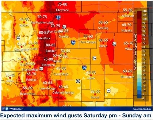
A high wind warning is in effect for much of Colorado, including Larimer County, from 8 a.m. Saturday to noon Sunday.
A red flag warning, which is an alert for higher likelihood of fire spreading, is also in effect from noon Saturday to 6 p.m. Sunday for the lower parts of Larimer, Boulder and northwest Weld counties.
"Don't burn or do anything to make sparks," the National Weather Service said in another post on X.com.
The strongest winds are expected from 6 p.m. Saturday to 6 a.m. Sunday, with 80 mph gusts likely, the NWS said, and 100 mph gusts possible in the foothills. Gusts of up to 70 mph are expected on the northeast plains.
In Fort Collins, winds could reach around 70 to 75 mph.
Here's a map showing the progression of wind speeds, created by the National Weather Service.
🕵️👀Interested in the arrival time of high winds at your specific location?
Check out this animation of expected wind progression from midnight tonight - 6 am Sunday. #COwx pic.twitter.com/RhoQAbA110— NWS Boulder (@NWSBoulder) April 5, 2024
Here's the weekend forecast for Fort Collins
According to the National Weather Service:
Saturday: Strong winds. Patchy blowing dust in the morning. Areas of blowing dust in the afternoon. Rain showers, snow showers likely and slight chance of thunderstorms. Snow accumulation up to 1 inch. Highs 43 to 49. Northwest winds 25 to 35 mph with gusts up to 60 mph, increasing to 35 to 55 mph with gusts up to 75 mph in the afternoon. Chance of precipitation 70 percent.
Saturday night: Mostly cloudy with a 40% chance of snow showers. Areas of blowing dust. Strong winds. Lows 28 to 34. Northwest winds 40 to 60 mph with gusts up to 75 mph.
Sunday: Areas of blowing dust in the morning. Mostly cloudy with a chance of snow showers in the morning, then partly cloudy in the afternoon. Strong winds. Highs 47 to 55. Northwest winds 35 to 55 mph with gusts up to 75 mph, diminishing to 35 to 45 mph with gusts up to 65 mph in the afternoon. Chance of snow 30 percent.
Sunday night: Mostly clear. Lows in the mid 20s to lower 30s. Northwest winds 20 to 25 mph with gusts up to 50 mph.
Early next week should bring highs near 60 and some chances for precipitation.
This article originally appeared on Fort Collins Coloradoan: Windy Colorado: Xcel Energy cuts power, small fire outside Fort Collins

