Updates: Monday severe weather threat wanes; schools closed Tuesday ahead of next round
Tallahassee is bracing for the possibility of multiple rounds of severe weather today and Tuesday as the city continues to recover from three tornadoes and 100-mph straight-line winds that caused widespread wreckage just three days ago.
Both the city and county have opened sandbag locations in preparation for the storms, which comes at the same time that city and mutual aid electric repair crews are still working to fully restore power, bringing the number of customers in the dark below 10,000 Monday morning.
The threat diminished late Thursday afternoon, but the city faces another round of potential severe weather on Tuesday.
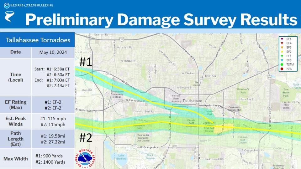
Meanwhile, the National Weather Service in Tallahassee confirmed the paths of three tornadoes, two EF-2s and one EF-1, that hit the city. One woman was killed when a tree fell on her home off Aenon Church Road.
Here’s the latest:
How state offices are affected by recent weather
Tallahassee-based workers for the Department of Agriculture and Consumer Services have been asked to report at noon Tuesday, spokesperson Jessica Kelleher said.
"This will give us a chance to assess connectivity and any other storm impact," she said in an email. "We will adjust our report times accordingly."
Kylie Mason, communications director for Attorney General Ashley Moody, said Moody’s top staff is “monitoring the weather conditions overnight and will make a decision first thing in the morning” about when Tallahassee offices will open.
A call to the governor's office about executive branch agencies in Tallahassee was not returned by Monday evening but a spokesperson for the Department of Management Services, the state's real estate manager, said "all DMS-managed facilities stayed open (Monday), except for the Bob Martinez Center (on Blair Stone Road). It’s still closed because power hasn’t been restored after last week’s storm."
PSC reporting more Tallahassee power outages
After a swath of bad weather Monday, the Florida Public Service Commission is reporting more power outages under the City of Tallahassee in the evening than it did in the morning.
The PSC reported 15,150 customer outages at 5:55 p.m. Monday. That number was at 9,574 in its data released 12 hours before.
Meanwhile, the city's outage map, which often over the last several days has lagged behind the PSC data, is reporting less than 13,000 customer outages.
Leon County Schools closed Tuesday amid possibility of severe weather
The School District made the call.
This is the letter that went out to parents, employees and the media.
"Schools will be closed in Leon County on Tuesday, May 14 due to anticipated severe weather entering our area beginning at 6:00 a.m. potentially making roads impassable and compounding the impacts of the previous severe weather in our area."
"The decision to close schools was made after consulting with the National Weather Service, Leon County Emergency Management and getting feedback from every LCS principal."
"We are in communication with the Florida Department of Education in regards to required instructional minutes to confirm that our seniors in the class of 2024 will have enough hours to graduate without having to extend the school year."
"Our high schools will be adjusting their AP & IB schedules and each school will communicate directly with those students waiting to take a test. Make ups will be scheduled during the required late testing windows identified by the AP and IB organizations — not LCS."
"Bus routes will be checked in the afternoon to identify any possible issues prior to Wednesday."
"Non-school based District staff is expected to arrive to work by 9:00 a.m. tomorrow."
"If weather permits, some schools may proceed with afterschool and evening activities."
Severe weather threat diminished; Leon County no longer under tornado watch, but forecasters say to stay on guard
And now for some good news.
"Rain-cooled and stable air has brought an end to the tornado/severe threat for many," the National Weather Service posted on X. "Still watching some areas across the coastal areas of the Apalachee Bay and the southeast Big Bend for a severe threat."
Leon County was even removed from the tornado watch, but it remains for neighboring counties.
Rain-cooled and stable air has brought an end to the tornado/severe threat for many. Still watching some areas across the coastal areas of the Apalachee Bay and the southeast Big Bend for a severe threat. Here is where the tornado watch is currently in effect: #FLwx #ALwx #GAwx pic.twitter.com/ag6jD26T2n
— NWS Tallahassee (@NWSTallahassee) May 13, 2024
"There will still be heavy rain through the afternoon hours but we'll likely see a lull in the activity for much of the evening," the agency wrote.
Initially, forecasters feared that the area – already reeling from an unprecedented trifecta of tornadoes – could see 75 mph winds and significant flooding.
But based on radar trends and observations, that threat has diminished as the storm has become more of a coastal threat.
Forecasters still warn the situation could shift after the storm system lashed inland cities to the west. For example, Milton clocked an 82 mph gust earlier in the day.
Funnel Cloud at St. Andrew’s State Park in Panama City Beach #flwx @NWSTallahassee @Whitleyweather @pcbwx @spann @sandman_pcb pic.twitter.com/ItNKsxlIe9
— Austin. (@aallenpcb) May 13, 2024
Israel Gonzalez, with the National Weather Service of Tallahassee, also warned that even moderate rain can undermine the foundation of trees already weakened by Friday's tornadoes.
The region will also have to be on guard Tuesday for "renewed" severe weather activity. Leon County is under a slight risk or level 2 out of 5 on the threat matrix.
"There is still some uncertainty," Gonzalez said. "And still some reasonably high confidence that the threat is still there."
Leon County Commissioner Christian Caban sets up emergency distribution centers
As soon as Gov. Ron DeSantis declared a state of emergency for Tallahassee in the wake of Friday's storms, Leon County Commissioner Christian Caban got to work by issuing a resource request to the state to set up food and water distribution centers in his home District 2 and beyond.
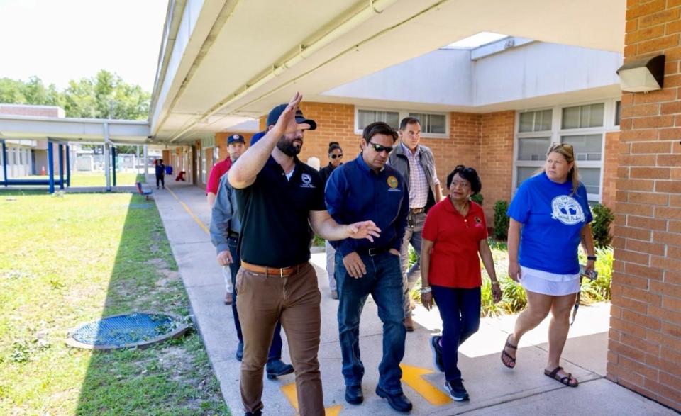
As he toured damage and assisted in the recovery effort Saturday at Sabal Palm Elementary, Caban met with the governor along with county commission Chair Carolyn Cummings.
Three locations opened on Saturday morning and have been running all weekend into Monday: Jane G. Sauls Fort Braden Branch Library, J. Lewis Hall Sr. Woodville Park and Apalachee Regional Park.
As of Monday morning, the sites had distributed 140,000 bottles of water and 35,000 ready-to-eat meals. More than 3,000 cars have visited the centers combined.
They also started distributing tarps early Monday morning ahead of incoming storms.
Center operations have been canceled for the rest of Monday because of adverse weather. They’re expected to open at an unknown time tomorrow morning and are anticipated to run through Tuesday at 7 p.m. pending weather.
Residents can head to the centers and receive drive-thru service. For information on when the centers open tomorrow residents are encouraged to visit the county website: https://cms.leoncountyfl.gov/ei.
Mayor Dailey talks about historic damages, impending storm in interview
Tallahassee Mayor John Dailey called the damages from Friday morning's storm "historic."
In a Monday afternoon phone interview, Dailey said he doesn't think any storm has caused more damage than what was seen Friday.

But now there's another storm coming toward Tallahassee. Depending on its severity, he warned it could delay power restoration efforts or inflict more damage on the power grid. He also addressed resident concerns about the city's outage map, which has been lagging far behind the pace of progress.
Tallahassee might miss brunt of incoming severe weather
The brunt of the incoming severe storm threat may by most felt by some of North Florida's coastal areas, according to a recent post by the National Weather Service in Tallahassee.
The severe threat appears to be confined more to the coast (white outlined area) as cool and stable conditions from constant rain this morning and early afternoon has prevented the instability needed for severe storms from spreading north. #FLwx pic.twitter.com/yvRTXKNqnp
— NWS Tallahassee (@NWSTallahassee) May 13, 2024
That's good news for city residents, but bad news for places like Port Saint Joe, Panama City and Crawfordville.
All are encircled in a visual provided by NWS: "The severe threat appears to be confined more to the coast (white outlined area) as cool and stable conditions from constant rain this morning and early afternoon has prevented the instability needed for severe storms from spreading north," it wrote at 2:33 p.m.
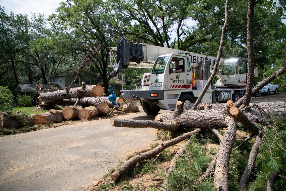
One family's story of storm destruction
It was a typical Friday morning in the Fore household. Mother, father and teenager daughter were set to leave their Lehigh Acres home when things suddenly were no longer typical.
They heard a loud roar and the next thing they knew the sound was in the house.
“The ceiling was cracking down. The wind was coming in. Everybody thought they were going to die,” said Michael Fore, the father, in a Monday morning interview. “It sounded like you knew there was going to be a big crash.”
There was.
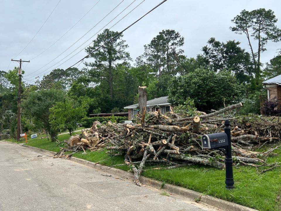
A huge pine tree crushed two bedrooms of their Lola Drive home. No one was hurt.
“I got the tree off the house, everything covered up and got what I could pack away,” Fore said.
He estimates it may cost $80,000 to repair and replace what was lost in the storm. An insurance company representative is scheduled to survey the damages Wednesday.
Mayor Dailey says coming storm could delay power repairs
Tallahassee Mayor John Dailey said the damage from Friday’s storm was worse than that from Hurricane Hermine, Hurricane Michael and Hurricane Irma combined.
“Having said that, the electric utility crews have been working around the clock,” Dailey said in a Monday afternoon social media video. The city of Tallahassee announced shortly after 9 p.m. Sunday that it had restored power to 91% of its customers.
Monday Afternoon Weather Update pic.twitter.com/Lx15vKybkc
— Mayor John Dailey (@MayorOfTLH) May 13, 2024
But Dailey warned the work could be delayed by another severe storm expected to hit later in the day.
“We’re going to have the crews out working as long as we possibly can,” he said. “If it becomes unsafe, we’ll pull them in until it becomes safe, and then we’ll send them back out.
The forecast is calling for 2-5 inches of rain. The National Weather Service in Tallahassee says 75 mph wind is likely in North Florida and ping pong ball-sized hail is possible until 7 p.m.
“We’re going to make it,” Dailey said. “We’re going to continue to move forward. We’re Tallahassee strong. Be safe.”
North Florida, Big Bend, Tallahassee under a tornado watch until 7 p.m.
The region is now under a tornado watch until 7 p.m. with 75 mph winds likely, according to the National Weather Service in Tallahassee.
The NWS warns that scattered gusts of 75 mph are likely, which would surely complicate the momentous recovery process that is currently ongoing in Florida's capital city. It also threatens to plunge thousands back into darkness after city crews augmented by reinforcements from around the nation brought the number of outages below 10,000.
A tornado watch has been issued for parts of Florida until 7 PM EDT pic.twitter.com/lB6tWOCoN0
— NWS Tallahassee (@NWSTallahassee) May 13, 2024
"A couple of tornadoes" are also possible along with ping-pong sized hail, according to a post on X by the weather service.
Leon County Schools closing at 1 p.m.
Leon County Schools is closing again and cutting the school day short as a new threat looms.
"After consultation with weather experts and our school leaders, we have made the decision to close our schools at 1:00pm today (5/13/24) due to the possibility of severe weather this afternoon. Parents can choose to pick their students up early if necessary," the School district said in a post on X.
All afterschool activities have also been canceled.
The announcement is the latest schedule adjustment and then cancellation as school district adminstrators try to navigate the quickly changing dynamics of a recent barrage of sever weather.
Already administrators had delayed the school start time, cancelled busses and scrapped testing to get kids on school Monday.
Amid a sea of angst and anger on social media, the district has been limiting comments on its posts and school announcements as parents have questioned the district's decisions.
This is a developing post.
Rounds of severe weather begin rolling into Tallahassee with threat of straight line winds
The National Weather Service warns that a wide swatch of the Tallahassee area should prepare for 40 mph winds and pea-sized hail over the next 15 minutes until 11:30 a.m. Forecasters expect multiple rounds of severe weather today and into Tuesday.
Watching a storm move into Tallahassee. Brief 30 to 40 mph wind gusts are possible which could possibly bring issues to any weakened trees across the area. #FLwx #Tallahassee pic.twitter.com/bLzhC3hGsr
— NWS Tallahassee (@NWSTallahassee) May 13, 2024
"Watching a storm move into Tallahassee," forecasters wrote on X. "Brief 30 to 40 mph wind gusts are possible which could possibly bring issues to any weakened trees across the area."
Forecasters are particularly worried about straight-line winds, which wreaked havoc
"Straight line winds can cause just as much damage as a tornado." "So if a severe thunderstorm warning comes out, it needs to be treated the same as a tornado warning!"
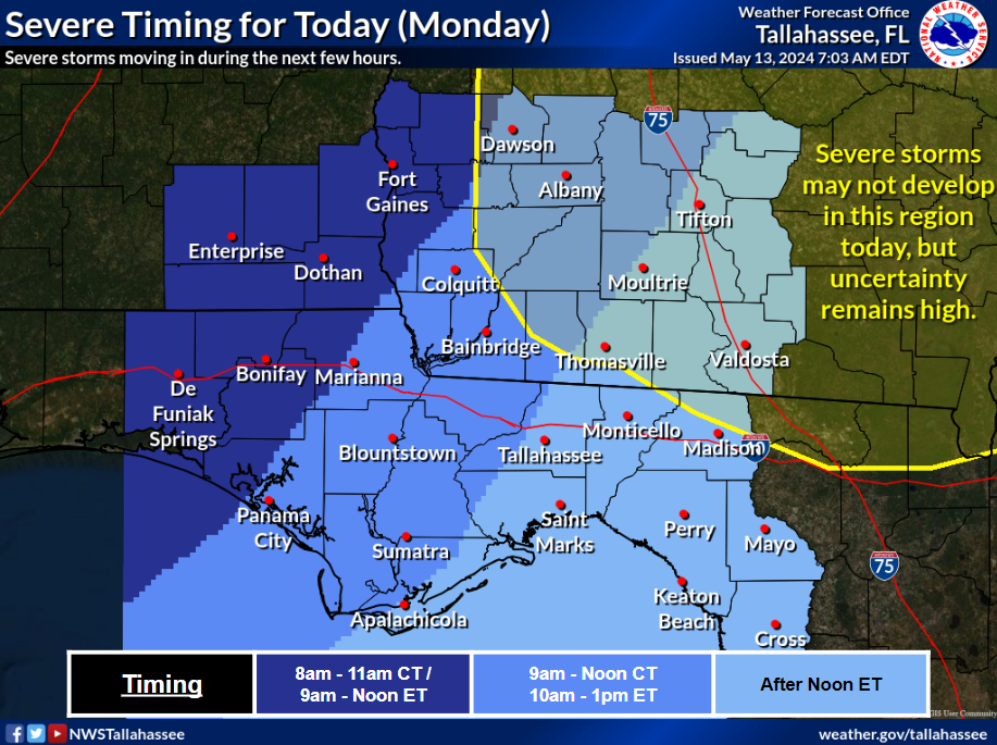
Severe storms, heavy rain possible with storms moving in today
The Tallahassee area is expected to see multiple waves of storms from an upper-level disturbance over the southeastern U.S.
Wright Dobbs, meteorologist with the National Weather Service in Tallahassee, said the first round of storms could arrive as soon as this morning or afternoon and that the threat could continue through much of Tuesday.
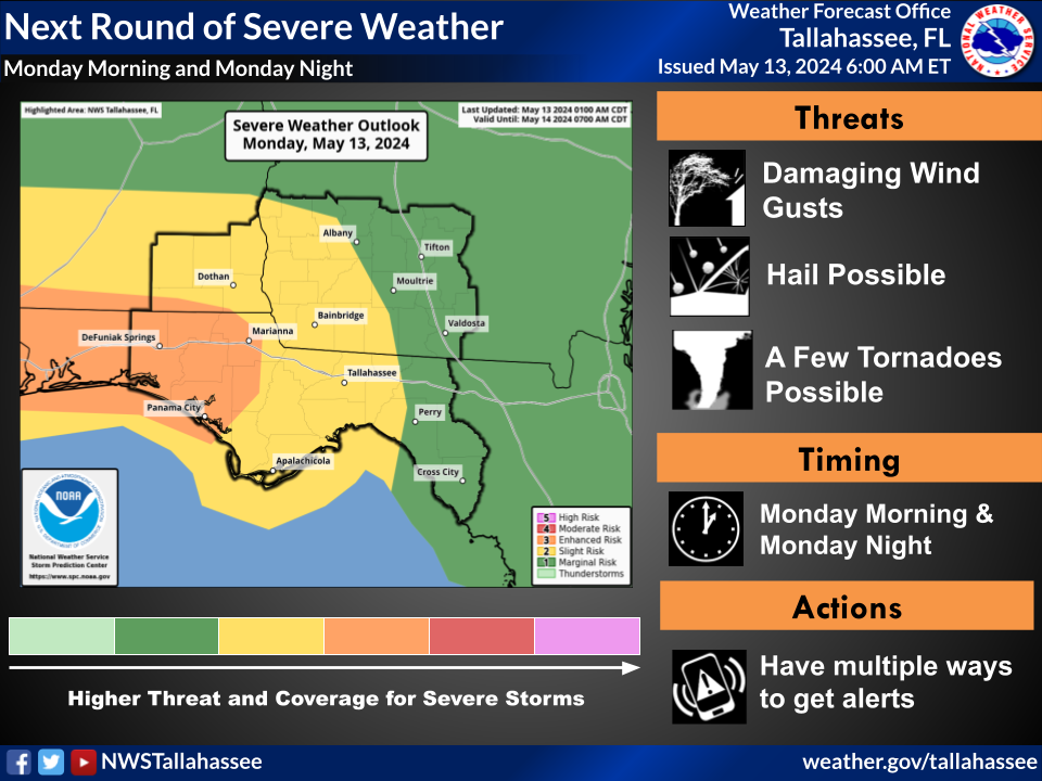
“The main thing we’re going to be concerned about is that damaging wind potential,” Dobbs said. “But a few storms might have the potential for a tornado or maybe hail in some areas.”
Dobbs said residents in the Tallahassee area should be prepared for the possibility of 60 mph gusts, with higher speeds from the most severe storms. Flooding is a possibility, with the forecast calling for 2-5 inches of rain with higher amounts possible in isolated areas.
The Storm Prediction Center shows a slight risk (2 on a scale of 1-5) for severe weather today and a marginal risk (1 out of 5) Tuesday. The risk is higher (3 out of 5) for places like Marianna and Panama City.
The Weather Service issued a flood watch for the central Big Bend and South Georgia, extending from the Apalachicola area through Tallahassee and up to Albany, Georgia.
“In addition to the possibility of severe weather that all these rounds of storms could bring, we’re also worried about the potential for heavy rainfall,” Dobbs said. “Sometimes when we get storm systems like this that set up on an east-west boundary, we can get training storms, where storms move repeatedly over an area. And they might not bring severe weather, but they can bring very heavy rainfall.”
City of Tallahassee outages drops under 10K though lagging outage map shows many more
The city of Tallahassee announced shortly after 9 p.m. Sunday that it had restored power to 91% of its customers. The latest figures from the state of Florida showed that of the cities 126,309 accounts, 9,574, or 8%, were still without power.
"Crews including mutual aid will continue to work through the night and 24/7 until full restoration," the city said in a text message to utility customers.
The city said 400 mutual aid workers were assisting city crews in restoring the electric grid, with restoration resources five times higher than normal.
The city's online power outage map, which has not been able to keep up with restoration efforts in real time, continued to show incorrect figures. The map, which is lagging far behind actual numbers, showed more than 18,000 customers out as of around 10:30 a.m. An official with the utility says the map is overtaxed by the volume of outages and the pace of the progress.
Power has been restored to all but 1,136 Talquin Electric Cooperative customers, according to the most recent state numbers. Some 4% of its 26,054 accounts were still down.
Contact Jeff Burlew at jburlew@tallahassee.com or 850-599-2180.
This article originally appeared on Tallahassee Democrat: Tallahassee tornado updates: Recovery continues; schools closed Tuesday

