Areas of frost overnight, tracking light rain Saturday
EVENING: Clearing skies, cool. Temps in the 50s.
TONIGHT: Clear and cool. Areas of frost. Low 36.
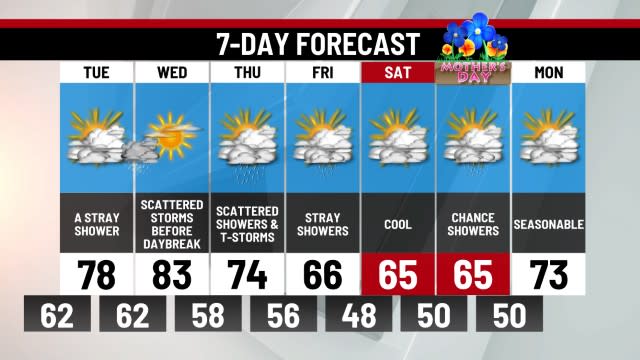
FRIDAY: Mostly sunny, comfortably cool. High 60.
Of all of our recent cool nights and frost potential, tonight will be the best chance for areas of frost to form under clear skies and calm winds. Temperatures will drop into the low/mid 30s.
Sunshine begins Friday and lasts all day. Afternoon temperatures will still be cooler than average as we reach the lower 60s.
The weekend will be split. Expect Saturday to be cool and cloudy. A few light showers will be around midday into the afternoon, but rainfall amounts will be small.
By Sunday, some sun and a building upper-level ridge will help take temperatures close to 80°. The pattern flips next week with daytime highs in the 80s and very little rainfall in the cards. April ends and May begins warmer and drier. We’ll keep you posted.
-Meteorologist Eric Finkenbinder
For the latest news, weather, sports, and streaming video, head to ABC27.

