Large hail may be part of strong to severe overnight storms affecting northeast Kansas
Two rounds of strong to severe thunderstorms — which could bring very large hail — are expected late Wednesday and early Thursday to affect north-central, northeast and east-central Kansas, forecasters say.
"Confidence in thunderstorms developing is moderate," the National Weather Service's Topeka office said in a graphic posted on its website. "Confidence in them being severe is medium."
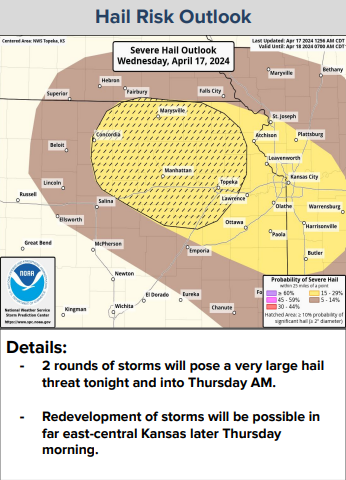
Topeka, Manhattan, Marysville and Concordia are all among locations anticipated to see a 15% to 29% chance for severe hail within 25 miles of any given point, said a separate graphic posted on that office's website.
Golf ball- to tennis ball-sized hail is possible with the first round of storms, which is expected to take place between 9 p.m. Wednesday and 3 a.m. Thursday, the weather service said.
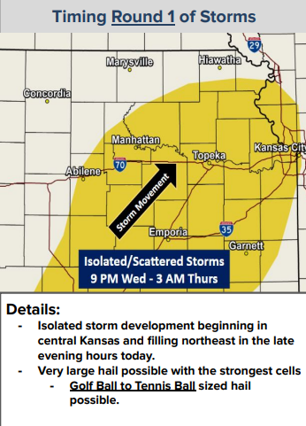
Those storms are expected to develop in central Kansas, then move northeast, it said.
Hail more than 2 inches in diameter will be possible with the second round of storms, the weather service said.
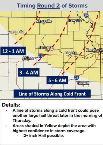
It indicated those are expected to affect an area that includes Concordia and Marysville around midnight to 1 a.m. Thursday; Abilene, Manhattan and Hiawatha around 3 to 4 a.m. Thursday; and Topeka around 5 to 6 a.m. Thursday.
The weather service encouraged residents to be weather aware and have multiple ways to receive warning information.
Contact Tim Hrenchir at threnchir@gannett.com or 785-213-5934.
This article originally appeared on Topeka Capital-Journal: Large hail may be part of overnight storms affecting northeast Kansas
