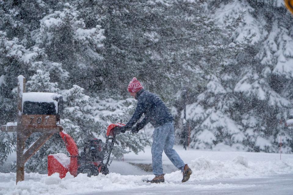
Wisconsin weather updates: Milwaukee gets 8 inches of snow as weather wanes
Much of Wisconsin woke up to snow Friday morning as a storm moved into the state overnight.
Here's what you should know about the forecast, snow totals and more.
We'll be updating this, so follow along and refresh your browser for the latest on the winter weather.
4 p.m.: Milwaukee receives 8 inches of snow as weather tapers off
In Milwaukee, it snowed a total of 8 inches on Friday, according to local National Weather Service meteorologist Kevin Wagner. Milwaukee, Waukesha and Jefferson counties received the heaviest snowfall in the state during this storm, he continued.
Major snowfall is now finished in the Milwaukee area, but light flurries or an "additional dusting" are possible this evening.
12:15 p.m.: Snow is still falling as National Weather Service releases preliminary snow totals
Snow is still falling throughout much of the state, including in Milwaukee.
At noon, NWS released a first look at snow totals for areas throughout the state but added that "there's a band of snow still occurring in southeast Wisconsin which could add on to what is showing up here."
Here are some updated totals from the NWS website:
Delafield: 8 inches
West Allis: 8 inches
Wauwatosa: 6.8 inches
Shawano: 6.5 inches
Fort Atkinson: 6 inches
Menomonee Falls: 5.5 inches
Germantown: 5.1 inches
Mequon: 5 inches
West Bend: 4.8 inches
Mount Horeb: 4 inches
Cedar Falls: 3.5 inches
Watertown: 3.5 inches
Pardeeville: 3 inches
Superior: 2.2 inches
11:45 a.m.: Snow wanes into the afternoon, winter weather advisory ends for Madison and surrounding areas
An 11:10 a.m. update from the National Weather Service showed that the snow has dwindled near Madison and northwest of the city. With that, the NWS ended a Winter Weather Advisory for that region, but Milwaukee and other parts of southeastern Wisconsin remain in one.
"There is lingering moderate snow for southeast Wisconsin and along the state line for another couple of hours, but should be tapering off through the afternoon," the report reads.
The NWS said that slushy travel and reduced visibility are main impacts, with the potential for some additional accumulating snow.
Snow gradually tapering off from the northwest and will continue thru the afternoon, but moderate snow with slushy travel and reduce visibility continues for SE WI, near the state line. #wiwx pic.twitter.com/uUW0DiOtcF
— NWS Milwaukee (@NWSMilwaukee) March 22, 2024
11:40 a.m.: Car crashes clear up as morning progresses
Most incidents and crashes have been cleared from earlier Friday morning, according to the report on 511 Wisconsin. As of 11 a.m. roadway conditions still remain slippery with some still snow covered sections.
9:05 a.m.: I-41/94 at WIS 20. The right shoulder is blocked due to a disabled vehicle.
9:31 a.m.: I-41/US 45 North at WIS 145. The right shoulder is blocked due to a disabled vehicle.
11:12 a.m.: I-43 North at Good Hope Rd. The right shoulder is blocked due to a disabled vehicle.
You can find the most up-to-date conditions on the 511 Wisconsin website.
10:30 a.m.: Snow shifts slightly north of Wisconsin-Illinois border
Heavy snow wobbled just north of the state line bringing increase snowfall rates and reduced visibilities for areas from Monroe to south of Milwaukee. Use caution if traveling! #wiwx pic.twitter.com/xfiRtgBO4U
— NWS Milwaukee (@NWSMilwaukee) March 22, 2024
The snowstorm has moved slightly north from the Wisconsin-Illinois border, with its main impacts near the border and just north of it.
Earlier in the morning, meteorologists had been monitoring the track of storm, which was initially straddling the two-state line. A 9:57 a.m. update from the National Weather Service showed that the main impacts — reduced visibility from heavy snowfall rates and slick and slushy road conditions — showed the storm is still on that path, but has moved slightly north, towards Milwaukee.
"It’s been working its way northward a little bit, the metro is going to be clipped by this for the next few hours. It’s snowing currently, but the heaviest snowfall is just on the doorstep of downtown," said Tim Halbach, a local meteorologist.
Snow should not stick around long on roadways.
That's due to the temperature and the sun angle, Halbach said. That's helped keep the pavement temperatures a bit warmer and stave off snow accumulation, melting it to slush. Due to that, the snowfall rate, which the organization said could reach about an inch an hour, is mostly accumulating on non-roadway surfaces, he said.
The storm's "backside" is moving through southwestern and central Wisconsin through the morning as well, he said.
10 a.m.: Milwaukee cancels garbage and recycling collections
The Milwaukee Department of Public Works canceled trash collection for the day as they focus on snow and ice plowing instead.
Garbage and recycling workers will instead mount plow blades on their trucks and assist in snow control, the city announced in an email. Service will be made up next week, the email read.
The city's garbage collection schedule can be found here.
9 a.m.: Traffic update and road conditions report
Slippery roadway conditions continue to affect drivers in Milwaukee and across Wisconsin on Friday morning as of 9 a.m. Several traffic incidents and crashes are creating closures, according to the 511 Wisconsin report:
7:43 a.m.: I-94 West at WIS 164/County J. The right shoulder is blocked due to a crash.
8:09 a.m.: I-94 West .2 miles beyond County T. The right lane is blocked due to a crash.
8:14 a.m.: Crash on I-43 North on-ramp from Brown Deer Rd.
8:19 a.m.: I-43 South at Ramp from Layton Ave. The right shoulder is blocked due to a disabled vehicle.
8:44 a.m.: I-41/43/894 East at 76-84th St. The center lane is blocked due to a disabled vehicle.
8:47 a.m.: I-43 South .3 miles beyond I-43 South. The right lane is blocked due to a disabled vehicle
You can find the most up-to-date conditions on the 511 Wisconsin website.
All lanes are now open as of 8:46 a.m. at Mequon Rd on I-43 in Ozaukee County after to a crash that occurred at 7:30 a.m., according to WisDot.
8:30 a.m.: Snow totals now above 6 inches in much of southeastern Wisconsin
It has continued to snow into the morning throughout southeastern Wisconsin. Updated snow totals from the National Weather Service show that some areas have received over 6 inches of snow:
West Allis: 7.9 inches
West Milwaukee: 7.7 inches
New Berlin: 7 inches
Big Bend: 6.9 inches
Sullivan: 6.4 inches
Fort Atkinson: 6.3 inches
Greendale: 6.1 inches
Brookfield: 6 inches
St. Francis: 5.8 inches
Franklin: 4.8 inches
Oak Creek: 4 inches
Kenosha: 3.5 inches
For the most complete and up-to-date statewide snow totals, visit the National Weather Service website.
8:15 a.m.: I-43 northbound closed in Ozaukee County
All lanes are closed at Mequon Rd on I-43 in Ozaukee County due to a crash that occured at 7:30 a.m., according to WisDot. Estimated time of closure is 2 hours.
8:10 a.m.: Airport ‘fully operational’ after Friday snow
Milwaukee Mitchell International Airport is running with no issues from Friday’s snowstorm.
Summer Hegranes, an airport spokesperson, said that the airport’s snow team had been out plowing the runways to maintain them for flights. Almost all flights were on time this morning as well, she said.
“Of course with any weather, that can change,” Hegranes said. “But any changes are determined by the airline.”
She said travelers should check with their airline or various mobile apps for any status updates. The airport website also offers some information on flight statuses. Information on arrivals can be found here, and departures here.
8 a.m.: Snow came in bands, leaving southern Wisconsin with higher totals and northern cities with about 1 inch
Friday’s snowstorm hit Wisconsin in bands overnight, with some parts of the state getting totals as low as an inch and over six in Milwaukee.
The storm has brought two different bands across the state, one on I-94 corridor between Madison and Milwaukee, and another in the central part of the state that stretches up to Green Bay, said Andrew Quigley, a meteorologist from the local National Weather Service.
In those areas, most received between two and four inches of snowfall overnight. Totals should come into focus as the morning progresses and the sun rises, Quigley said.
“Overnight, we basically had bands of snowfall set up across southern Wisconsin,” he said. “With these bands, not every (area) was treated equally in terms of accumulation.”
As the day progresses, another band of snow is expected to add more to the totals. However, that snow band is currently over Iowa and in northern Illinois, he said.
Where most of that snow falls depends on the track its takes.
“Whether or not it jogs a little bit further north or south is something that we’re still watching for and is still a possibility,” Quigley said. “Right now, it does look like this second round of snow coming in is going to be near the state line of Wisconsin and Illinois.”
7:35 a.m.: Milwaukee commuters see delays on nearly all major highways
Slippery and snowy conditions are affecting road conditions in Milwaukee and across Wisconsin after heavy snow fell overnight and into Friday morning. Roadway conditions across most of the state remain slippery with snow covered stretches as of 7:30 a.m. Friday, according to a 511 report.
Several traffic incidents were reported this morning, according to the 511 report:
6:12 a.m.: I-794 East at Carferry Dr. The center lane is blocked due to a crash.
6:36 a.m.: I-43 South at Ramp from Wells St. The right shoulder is blocked due to a disabled vehicle.
6:59 a.m.: I-94 East at 84th St. The right shoulder is blocked due to a crash.
7:09 a.m.: I-94 West .03 miles beyond Ramp from Moorland Rd. The right shoulder is blocked due to a crash.
7:10 a.m.: I-41/US 45 North at North Ave. The right lane is blocked due to a disabled vehicle
7:10 a.m.: I-94 East at Moorland Rd. The right shoulder is blocked due to a disabled vehicle.
7:15 a.m.: I/41/US 45 North Closed at North Ave. because of a disabled vehicle.
7:16 a.m.: I-94 East at I-41/894 South. The left lane is blocked due to a crash.
7:19 a.m.: Crash on Ramp from 60th St. to I-41/43/894 West.
7:45 a.m.: I-43 North closed beyond Port Washington Rd because of crash.
Milwaukee County Transit Service is operating regular service Friday, though delays are possible due to the snow, they announced on Twitter Friday morning.
You can find the most up-to-date conditions on the 511 Wisconsin website.
7:35 a.m.: Some local schools closed in Milwaukee
Friday’s storm was prompting some schools to close.
Private schools like Badger State Baptist School, Mother of Good Counsel School and Pathways High School Milwaukee had all posted Friday closure on WTMJ-TV Channel 4’s tracker.
Milwaukee Public Schools started its spring break today, so wouldn't need to cancel class for inclement weather. Other schools, like Grandview High School and the Milwaukee Academy of Science, are holding only virtual classes.
Many area school districts start spring break next week. Other major area school districts like Wauwatosa School District, The School District of Menomonee Falls and Elmbrook Schools had not announced closures either.
A full list of school closings and delays can be found at WTMJ-TV Channel 4’s website.
7:30 a.m.: How much snow fell overnight in Milwaukee, Madison, Appleton and more
Here are the most recent statewide snow totals, according to data from the National Weather Service and its volunteer monitoring service:
Milwaukee airport: 6.3 inches
Brown Deer: 5.5 inches
Red River: 5.5 inches
Ashwaubenon: 5.4 inches
Mukwonago: 5.2 inches
Jefferson: 5 inches
Wauwatosa: 5 inches
Brookfield: 4.9 inches
Plover: 4.6 inches
New London: 4.3 inches
Menomonie: 4.2 inches
Two Rivers: 4.1 inches
Germantown: 4 inches
Merrill: 3.7 inches
Altoona: 3.4 inches
Madison: 3.4 inches
Weston: 3.4 inches
Appleton: 3.1 inches
Racine: 3 inches
Oconto Falls: 2.6 inches
Elk Creek: 2.5 inches
Plymouth: 2.5 inches
Reedsburg: 2.3 inches
De Soto: 2.1 inches
French Island: 2 inches
Omro: 2 inches
Hayward: 1.7 inches
6:30 a.m.: Milwaukee projected to get 3 to 6 inches of snow, morning commute impacted
After forecasts throughout the week predicted between two to eight inches of snow, the local National Weather Service is now projecting three to six inches of snow to fall in Milwaukee.
That’s according to the latest forecasts from the NWS released at 5:58 a.m. The organization is anticipating widespread accumulations between two to five inches throughout the state.
The snowfall is expected to peak between 7 a.m. and noon, with rates hitting one inch an hour south of I-94 and near the Wisconsin-Illinois border, according to a winter weather advisory.
Snow will continue in banded fashion into the post-dawn hours. Shortly after dawn, focus should shift to a heavier band that will set up along the Wisconsin/Illinois border. Snowfall rates should be around 1 inch per hour in the band, causing morning travel impacts #wiwx pic.twitter.com/QeD1YXEplc
— NWS Milwaukee (@NWSMilwaukee) March 22, 2024
The winter weather was already causing difficulties this morning. The state Department of Transportation’s 511 winter road condition map showed slippery stretches throughout much of the Milwaukee area, with some roads snow covered as well.
There six car crashes in the Milwaukee metro area as of 6:20 a.m., according to the map.
How much snow is forecast for the Milwaukee area and other parts of Wisconsin?
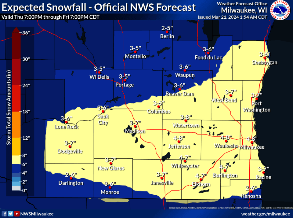
On Thursday, the National Weather Service projected four to eight inches of snow for the Milwaukee area Friday.
It’s likely to be a heavy, wet snow that falls during the Friday morning commute along the Interstate 94 corridor and south of it, potentially causing issues with visibility and traction.
Thursday's forecasts bumped up the expected snow in Milwaukee, from what was previously projected to be two to five inches of snow.
Around southeastern Wisconsin, snow totals are expected to between three to eight inches. Most of the state is expected to get at least two inches, except for the northernmost areas.
Temperatures are projected for the low 30s and winds should maintain around 10 mph.
“Fortunately, the winds from the storm will not play a huge role in its impacts,” Ben Sheppard, a local National Weather Service meteorologist, said Thursday.
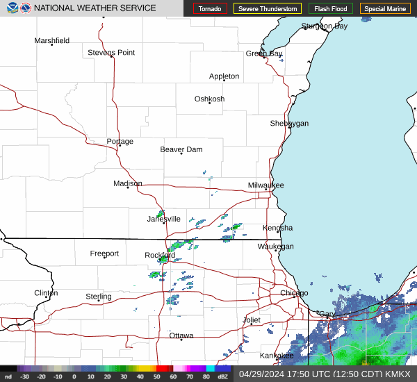
Take a look at Wisconsin's weather radar
When will it start snowing?
Snow is expected to start about 1 a.m. Friday and fall until about 4 p.m. in the Milwaukee area, with the storm’s peak intensity around 10 a.m., according to the NWS.
Are there any severe weather warnings issued?
The Milwaukee area is under a winter weather advisory from 1 a.m. to 4 p.m. Friday. In most other areas of Wisconsin, the advisory starts at 1 a.m. but ends in the late morning or early afternoon.
Wisconsin weather warnings map
Where can I find the latest Wisconsin winter weather road conditions?
Check out the the 511 WI website for the latest traffic updates and any road closures across Wisconsin. Stay up to date via its X/Twitter account.
This article originally appeared on Appleton Post-Crescent: Wisconsin live snow updates: Milwaukee forecast, totals, traffic

