Weather alert: Severe storms and isolated tornadoes possible in northern Ohio on Thursday
A cloudy Wednesday is setting the stage for weather doom and gloom that will arrive overnight.
The National Weather Service in Cleveland says moderate to heavy rain that will start Wednesday night through Friday could lead to some flooding along northern Ohio rivers and in some flood-prone areas.
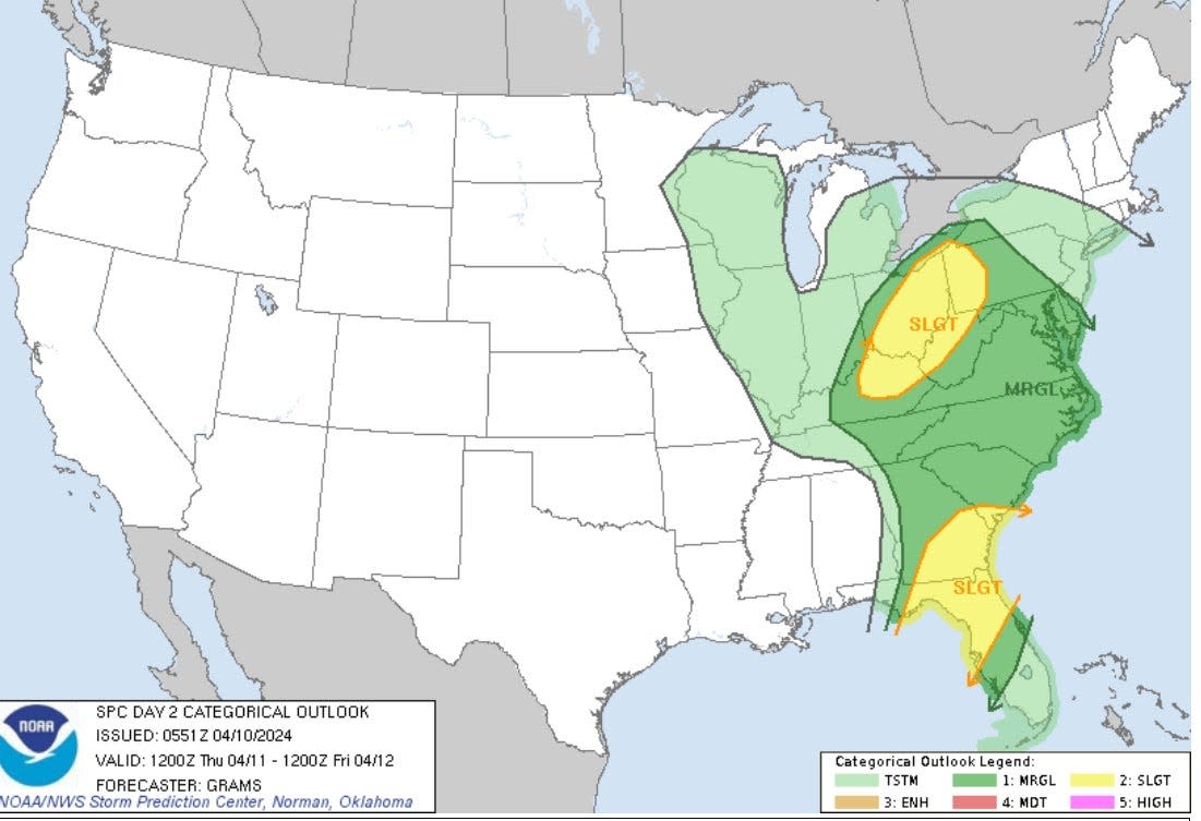
The National Storm Prediction Center says northern Ohio is at a "slight" risk for severe storms on Thursday.
The weather service says the "window" for the strong storms is from 2 p.m. to 10 p.m. on Thursday.
The biggest threat from the storms is "damaging wind gusts, a tornado or two, and large hail."
And the winds will increase too.
Wind gusts of anywhere from 35 to 45 mph are possible on Thursday with gusts of more than 45 mph possible on Friday.
Things are expected to settle down on Saturday with sunny skies in the forecast but the rains return on Sunday.
Here's the weather forecast
Wednesday: A chance of showers. Cloudy, with a high near 64. Light and variable wind. Chance of precipitation is 30%. New precipitation amounts of less than a tenth of an inch possible.
Wednesday night: Showers. Low around 57. East wind 5 to 9 mph. Chance of precipitation is 100%. New precipitation amounts between a tenth and quarter of an inch possible.
Thursday: A chance of showers and thunderstorms, then showers and possibly a thunderstorm after 8 a.m. High near 69. Southeast wind 15 to 18 mph, with gusts as high as 33 mph. Chance of precipitation is 100%. New rainfall amounts between three quarters and one inch possible.
Thursday night: Showers and possibly a thunderstorm before 11 p.m., then showers between 11 p.m. and 2 a.m., then showers likely and possibly a thunderstorm after 2 a.m. Low around 46. Breezy, with a southwest wind 18 to 20 mph, with gusts as high as 34 mph. Chance of precipitation is 90%. New rainfall amounts between a quarter and half of an inch possible.
Friday: Showers. High near 51. Breezy, with a west wind 20 to 24 mph, with gusts as high as 41 mph. Chance of precipitation is 100%. New precipitation amounts between a tenth and quarter of an inch possible.
Friday night: A chance of showers before 2 a.m. Mostly cloudy, with a low around 41. Breezy. Chance of precipitation is 30%. New precipitation amounts of less than a tenth of an inch possible.
Saturday: Sunny, with a high near 60. Breezy.
Saturday night: Partly cloudy, with a low around 47.
Sunday: A chance of showers after 8 a.m. Partly sunny, with a high near 71. Breezy. Chance of precipitation is 40%.
Sunday night: A chance of showers before 8 p.m., then a chance of showers and thunderstorms between 8 p.m. and 2 a.m., then a chance of showers after 2 a.m. Mostly cloudy, with a low around 53. Chance of precipitation is 40%.
Monday: A chance of showers. Mostly sunny, with a high near 70. Chance of precipitation is 30%.
Monday night: A chance of showers. Partly cloudy, with a low around 51. Chance of precipitation is 30%.
Tuesday: A chance of showers. Partly sunny, with a high near 72. Chance of precipitation is 50%.
This article originally appeared on Akron Beacon Journal: Greater Akron weather forecast showing rain, thunderstorms, high winds

