‘Substantial tornado threat’ looms as multiple thunderstorms likely in Kansas City area
Multiple rounds of powerful storms threaten to bring severe weather to the Kansas City area beginning Friday and continuing through the weekend, according to the National Weather Service.
There is a “relatively substantial tornado threat Friday afternoon and evening for eastern Kansas into western Missouri,” the weather service said.
The weather service’s Storm Prediction Center has placed the Kansas City area under an enhanced risk of severe weather. It says parts of eastern Nebraska, west and central Iowa, eastern Kansas and northwest Missouri are at a significant severe risk of a strong tornado.
“A few tornadic supercells are expected, with the greatest potential from near Omaha eastward to near Des Moines and southward to south of the Kansas City Metro,” the storm prediction center said. “Along this corridor, the more dominant supercell storms will also have a potential to produce hailstones greater than 2 inches in diameter and wind damage. “

The weather service said the severe weather threat in the Kansas City area will be between 4 and 10 p.m. The primary threats are large hail, damaging winds and a few strong tornadoes.
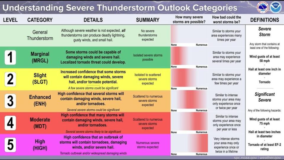
The weather service said on X, formerly Twitter, that it has been receiving questions about threat levels. They released a chart listing the five different levels.
“We average less than one moderate per year somewhere in our forecast area,” the weather service said. “Our last high risk day was in 2008! (and let’s keep it that way).”
Weekend forecast: more rounds of severe weather
Another round of severe weather is expected overnight Saturday, according to the weather service.
“The greatest threat is currently anticipated across parts of the central and southern Plains, where very large hail, damaging winds, and a few strong tornadoes will be possible,” the storm prediction center said.
Strong to severe thunderstorms will be possible in Kansas City between 4 p.m. and 4 a.m. Sunday, according to the weather service. The primary hazards are flash flooding, large hail, damaging winds and tornadoes.
According to the weather service, there will also be a slight risk of severe weather in the Kansas City area Sunday afternoon and evening. The thunderstorms will be capable of producing large hail, damaging winds and an isolated tornado.
All rounds of severe storms will bring heavy rain. Areas with repeated heavy rainfall may experience flash and river flooding, especially on Saturday.
An additional two to four inches of rain is expected through Sunday.
Weather watches and warnings
A live data feed from the National Weather Service containing official weather warnings, watches, and advisory statements. Tap warning areas for more details. Sources: NOAA, National Weather Service, NOAA GeoPlatform and Esri.

