Southern US flood risk to expand eastward along I-10, 20 corridors


Small streams, bayous and rivers will be on the rise into next week as rounds of torrential rain expand along the Interstate 10 and 20 corridors from northeastern Texas to northern Florida and southern Georgia, AccuWeather meteorologists warn. This is in addition to the high risk of flash urban flooding which can put lives and property at risk and significantly hamper travel in the region.
Many streams and rivers had receded at the start of the week, following their high water marks from last week in northeastern Texas following deluges from April to early May. However, some of the rivers are still well above flood stage and the ground remains moist, so any additional rain could cause water levels to rise quickly. There almost always is a delayed response in river levels following heavy rainfall because it takes a while for runoff to reach progressively larger streams.
Storms that rolled through during the latter part of Mother's Day weekend dropped more rain, on the order of 1-5 inches on northeastern Texas, northern and central Louisiana and central Mississippi, and were pushed eastward across the I-10 and 20 corridors of the Southeast on Monday. That runoff is slowly moving from small streams into secondary rivers.
A new burst of rain with 1-5 inches falling extended from the central and upper Texas Gulf Coast to northern Florida from Monday night to Tuesday. This additional burst of rain has raised river levels along the I-10 corridor with some surging to minor to moderate flood stage on Tuesday.
 |
Factoring in rain that has already fallen since Mother's Day, forward through Tuesday evening, totals could easily reach 6-8 inches from parts of northeastern Texas to the Florida Panhandle and southern Alabama with an AccuWeather Local StormMax™ of 12 inches.
The region will get a break from the heavy rain from west to east on Tuesday and Wednesday.
 |
That break may allow levels of swollen small streams and water in low-lying areas to drop. However, because it takes days for the water levels on larger rivers to react, many of the secondary rivers from northeastern Texas to southern Georgia and parts of South Carolina may continue to rise even though the sky may be clear overhead.
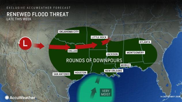
As water levels on streams and rivers continue to fluctuate, a new storm will push out from the southern Rockies on Wednesday and initiate a new surge of moisture from the Gulf of Mexico beginning on Thursday. Areas of drenching rain and thunderstorms will break out on Thursday and expand eastward on Friday and Saturday.
 |
Portions of the I-10 and 20 corridors will be subject to the consequences of more heavy rain on top of saturated ground and ongoing swollen streams and rivers. This may be a situation where some rivers level off or fall a bit then rise again, perhaps to new heights as runoff more efficiently reaches the larger waterways.
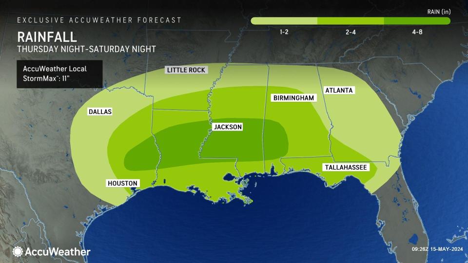
As was the case from earlier this week, 2-4 inches of rain will fall over a broad area of the Southern states with a band where 4-8 inches is most likely from northeastern Texas to central Louisiana and central Mississippi. Within this zone, there is an AccuWeather Local StormMax™ of 11 inches.
 |
The most significant flooding risk will be where all or most of the rounds of rain overlap. Combining the heaviest rain from earlier this week with the upcoming rain, some areas may pick up 12-24 inches in total. The overlap may be north of I-10 but may encompass areas along and south of I-20.
AccuWeather meteorologists urge people who live in flood-prone areas along small streams, bayous and rivers to closely monitor the situation and be prepared to take protective action or evacuate if the word is given. Aside from possible drowning, failure to do so may lead to being stranded without safe drinking water or electricity.
Rounds of heavy rain may target parts of the I-10 and 20 corridors of the South Central and Southeast states through much of May. This means that some communities may face multiple rounds of flooding in the coming days.
Larger gaps between the heavy rain events during the second half of the month could help to limit the amount of flooding or result in more localized flooding during the latter part of May.
Want next-level safety, ad-free? Unlock advanced, hyperlocal severe weather alerts when you subscribe to Premium+ on the AccuWeather app. AccuWeather Alerts™ are prompted by our expert meteorologists who monitor and analyze dangerous weather risks 24/7 to keep you and your family safer.
