Severe weather risk increases for Louisville. Here's what we know
Gusty rain showers will move into the Louisville area overnight Monday in what could be the start of a rough period of severe weather, according to latest forecast from the National Weather Service in Louisville.
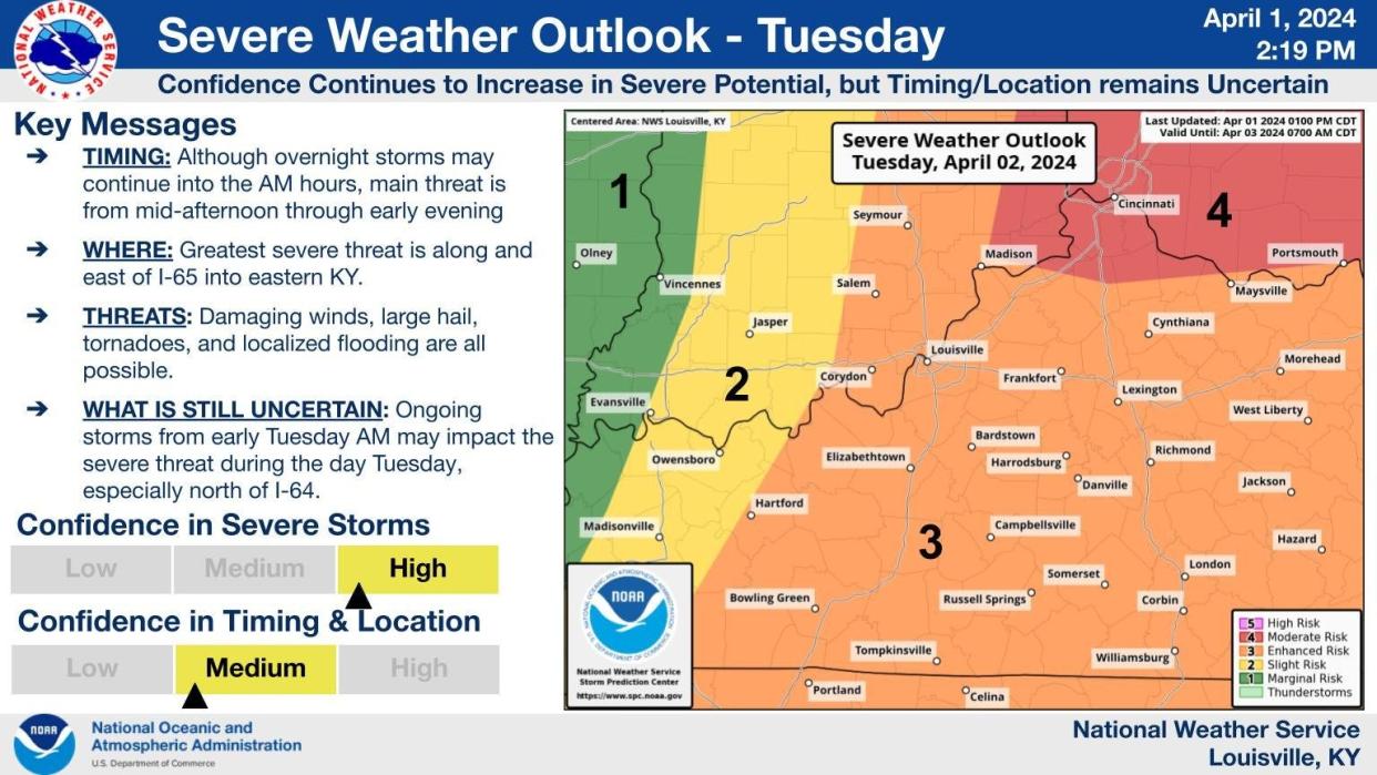
Storms could arrive as soon as 2 a.m., NWS Louisville chief meteorologist John Gordon said Monday afternoon. The system arriving Monday night, which could produce strong winds greater than 70 mph and flooding from heavy rains, falls into the weather service's "enhanced risk" category, .
The Storm Prediction Center issued a 5-9% chance for overnight tornadoes and a 15-29% chance for hail up to ping pong ball size. Louisville residents could also see winds greater than 58 mph and hail the size of a quarter or larger. There is a 30-44% chance these conditions appear Tuesday, according to the Storm Prediction Center.
Gordon said chances of severe weather could "bust" and bring a higher chance of tornadoes if rain showers and thunderstorms linger Tuesday into the afternoon.
"If we do not get those areas of showers and storms in the late morning, and that sun comes out, it's not going to be good," he said.
The weather service's confidence in severe weather occurring is "quite high," Gordon said, but there is still some uncertainty about exact timing and location of storms anticipated for Tuesday afternoon. Satellite data gathered tomorrow morning could give the weather service a clearer picture about what the afternoon will look like, he said.
Opinion: ‘There’s a tornado coming!’ Tracing the scars of Louisville’s F4 twister, 50 years later
Louisville weather forecast
Monday night: There will likely be showers and thunderstorms, mainly after 3 a.m. Some of the storms could produce gusty winds and heavy rain. The low temperature will be around 64 degrees, with south winds 7-10 mph. There is a 70% chance of precipitation. There could be between one-half and three-quarters of an inch of rain.
Tuesday: There will be showers and possibly a thunderstorm. The high will be near 74. Southwest winds will range from 13 to 21 mph, with gusts as high as 29 mph. There is an 90% chance of precipitation. There could be between one-half and three-quarters of an inch of rain.
Tuesday night: There will be showers and a possible thunderstorm before 11 p.m., then a chance of showers and thunderstorms between 11 p.m. and 2 a.m. The low will be around 40, with a west wind 11 to 18 mph, with gusts as high as 26 mph. There is a 40% chance of precipitation. There could be less than a tenth of an inch of rain, though higher amounts are possible in areas with thunderstorms.
Wednesday: Showers and thunderstorms are likely before 2 p.m., then showers and possibly a thunderstorm between 2 p.m. and 5 p.m., followed by showers after 5 p.m. The high will be near 49. It will be breezy, with a west wind 11 to 16 mph increasing to 17 to 22 mph in the afternoon. Winds could gust could be as high as 32 mph. There is an 80% chance of precipitation. There could be less than a tenth of an inch of rain, though higher amounts are possible in areas with thunderstorms.
Wednesday night: There will be rain showers before 2 a.m., then a chance of rain and snow showers. Some thunder is also possible. The low will be around 35. There is an 80% chance of precipitation. There could be less than a tenth of an inch of rain,
Thursday: There is a chance of rain and snow showers before 2 p.m., then a slight chance of rain showers. It will be mostly cloudy, with a high near 47. There is a 40% chance of precipitation.
Louisville weather radar
This article originally appeared on Louisville Courier Journal: Louisville weather: Hail, tornado risk increases for Tuesday, April 2

