Weather in Mississippi could be severe Friday. Here's what we know
Spring is known for violent weather and Central Mississippi may get a taste of it Friday.
Friday, 2 p.m. update
A severe thunderstorm watch has been issued for parts of Mississippi, Alabama, Florida and Louisiana until 7 p.m. The probability of severe weather has been upgraded from marginal to slight in some southern and coastal counties, MEMA said.
Friday, 10:15 a.m. update
The chance of severe storms in South Mississippi is marginal, according to the Mississippi Emergency Management Agency. Isolated severe thunderstorms are possible through early afternoon as a boundary pushes south through the area. Primary threats with these storms will be damaging wind gusts and quarter-sized hail, the National Weather Service added.
Power outage? Tips to help you weather being off the grid in Mississippi
⛈️ The threat for severe weather along and north of the I-10/12 corridor is increasing.
Damaging winds and hail will be the primary threat but cannot rule out a tornado.
A watch means the ingredients are in place for severe weather to occur. ⚠️📲 Stay weather aware today! https://t.co/sDO0KYA4u2— NWS New Orleans (@NWSNewOrleans) March 15, 2024
Friday, 8 a.m. update
A severe thunderstorm watch has been issued for parts of Mississippi and Alabama until 10 a.m., according to the National Weather Service.
A severe thunderstorm warning is in effect including De Kalb, Scooba and Electric Mills until 9 a.m.
Thursday, 1:44 p.m. update
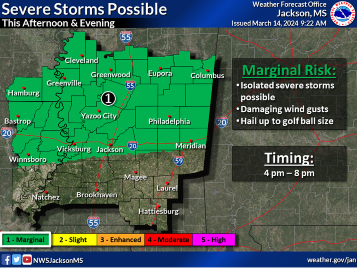
"We have a cold front that's going to move into the area later this afternoon and this evening," said Christopher Rainer, meteorologist with the National Weather Service in Jackson. "It could bring some isolated storms with primary concerns being damaging winds and hail up to golf ball size.
"Winds could be roughly 60 miles per hour. A fair amount of lightning is possible with the system."
According to the NWS, the primary area of concern is north of I-20. Rainer said storms should be moving into the area around 4 p.m. The threat of severe weather should dissipate about 8 p.m., but another threat could linger.
"As far as rain is concerned, we do have isolated flash-flooding potential," Rainer said. "We could have areas with 1 to 3 inches, with some localized areas having higher amounts."
That could push some rivers out of their banks in coming days, including the Pearl River, which is just over flood stage in the Jackson area at 28.4 feet.
"At the moment, we do have a few rivers that are receiving minor flooding," Rainer said. "With this approaching rain we could see some rivers get into minor flood stage and a few get into the moderate flood stage as well."
Although no tornado activity is forecast with the system, Mississippi is entering a dangerous time of year. On March 24, 2023, a series of tornadoes ripped through portions of the state killing more than 20 and all but leveling the town of Rolling Fork.
While this spring, which begins on March 19, isn't expected to be an exceptional year for tornadoes, NWS Meteorologist Logan Poole told The Clarion-Ledger in an earlier interview that Mississippi should be prepared.
"We live in one of the most severe weather, tornado-vulnerable areas in the nation," Poole said. "That just comes along with the territory."
The NWS is forecasting another round of storms to move into parts of Mississippi as early as 5 a.m. on Friday.
Do you have a story idea? Contact Brian Broom at 601-961-7225 or bbroom@gannett.com.
This article originally appeared on Mississippi Clarion Ledger: MS weather could be severe Friday

