Severe weather expected near St. Louis early Tuesday and Wednesday
ST. LOUIS — The first round of potentially severe storms will impact the St. Louis area Tuesday between 2 a.m. and 6 a.m. This is a Level 2 (out of 5) risk. An expansive band of strong to severe storms is expected to develop from Nebraska into Oklahoma late today and then sweep east tonight.
St. Louis radar: See a map of current weather here
These storms will be slowly weakening as they enter our area but may still be strong to severe when they get here. The threats will be from damaging straight line winds and a few small, quick hitting tornadoes.


Wednesday

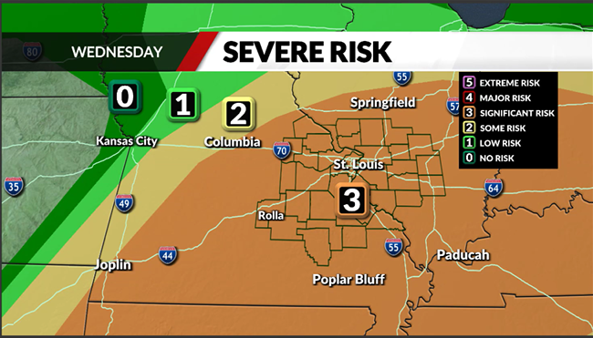
The most significant threat for severe weather this week looks to come on Wednesday. This is rated as a Level 3 out of 5, or significant risk. Indications are that storms may develop near St. Louis as early as midday and then spread rapidly east into Illinois, and southeast into southeast Missouri. These storms will be capable of damaging winds, very large hail and tornadoes. A few tornadoes cannot be ruled out.
For the latest news, weather, sports, and streaming video, head to FOX 2.

