NJ earthquake shook local geologists into action, sending them to precarious places
- Oops!Something went wrong.Please try again later.
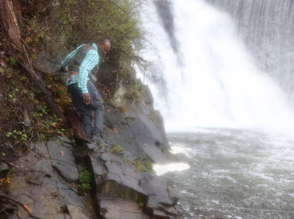
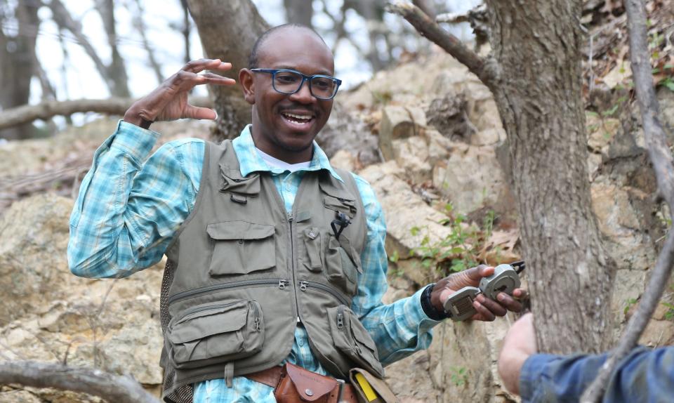
Folarin “Fola” Kolawole scrambled down a steep, slick, leaf-strewn embankment in Hunterdon County the other day, then gingerly edged his way across slippery stones lining the south branch of the Raritan River.
Next, Kolawole carefully approached a rock outcrop at the base of the dam that creates Lake Solitude, in High Bridge.
He ignored the roar of the water as it plunged over the four-story dam, and the thick mist that churned up from the cascading falls, and the man who stood in hip waders, ankle deep in the river, easing a twitching trout into his net.
Kolawole, a structural geologist, focused instead on the wet rocks in front of him. He pointed at some fractures. “That’s a fault rock,” he said with an edge of excitement.
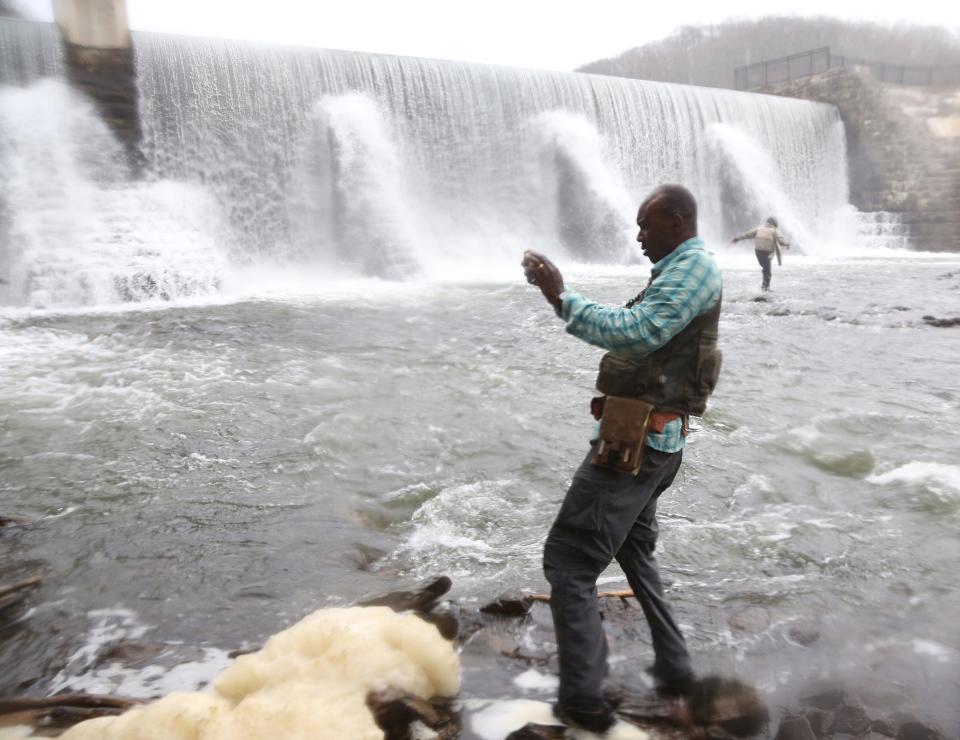
He pulled out a Brunton compass, and measured the angle and direction of the cracks in the outcrop, calling out the numbers so Zach Foster-Baril, a Columbia University post-doctoral research scientist, could record them on a smart tablet.
The measurements would help them create a three-dimensional representation of the cracks’ orientation and dip, to see if they lined up with one of the larger planes or faults in New Jersey’s underlying bedrock that likely slipped to cause the historic 4.8 magnitude earthquake that shook the region on April 5.
The quake, one of the strongest ever recorded in New Jersey, rattled tables and shook windows. People felt it from Washington to Boston.
Though it caused little damage, the quake, which occurred about 3 miles below the surface, provided a rare opportunity for scientists who study New Jersey’s geologic history to gather new data in real time as aftershocks reverberated through the Garden State’s bedrock.
“This has caused a lot of excitement for geologists,” said Kenneth Miller, a professor in the Earth and planetary sciences department at Rutgers University.
So they sprang into action.
In fact, on the day of the quake, Kolawole and two post-doctoral researchers packed into a car and rushed down to the epicenter area from Columbia’s Lamont-Doherty Earth Observatory in Palisades, New York.
After the quake hit, Kolawole thought, “Oh my God, I just have to come out in the field.”
By 5:58 p.m. they were taking measurements at a rock outcrop along a road cut, about a half mile from the earthquake’s epicenter in Whitehorse Station. Columbia post-doctoral research scholar Sean Kinney was at the top of the cut. Kolawole and Foster-Baril were below, at the road’s edge.
Then an aftershock hit — a magnitude 4, according to the U. S. Geological Service.
“It was terrifying,” Kolawole recalled. “It felt like a landslide.” He had experienced a 5.8 magnitude once, in Oklahoma — but this was the strongest he had experienced outside, walking along a fault.
“It felt like an explosion,” Kinney said. “With resonance.”
“And coming toward you,” Kolawole said. “It was so cool that we experienced that.”
Quake prods seismologists and geologists into action
Kolawole is not the only researcher to take advantage of the recent earthquake.
Right after the quake, for instance, James Bourke, a postdoctoral research fellow and seismologist at Rutgers University, rushed to his office on the Busch Campus to activate an unused seismometer he had stored there in the hope of recording aftershocks. The device picked up several soon after.
And in the week after the initial earthquake, the USGS said it was deploying eight “aftershock kits” to collect data on where aftershocks originate in the area, how long they last, and their magnitude, said Greg Tanner, a USGS electronics technician with the agency’s Albuquerque Seismological Laboratory. The quake has caused more than 50 aftershocks in the weeks since, according to the USGS.
The USGS is partnering with Rutgers, Columbia’s Lamont-Doherty Earth Observatory, the Texas Seismological Network at the University of Texas at Austin, and Yale University, which were also deploying seismic sensors.
When the quake hit, Rutgers’ Miller was in a Zoom call with two other Rutgers geologists scattered at different locations. “At first I’m thinking, ‘Is there a train going by?’” Miller said. “Then we all looked at each other in the Zoom call, stood up and shouted, ‘Earthquake!’”
Columbia’s Kolawole was in a lab group meeting the morning of the quake at Lamont-Doherty. “I started feeling the shaking and initially thought, ‘What is that?’” he said. “Then I felt the energy coming from below. We all just looked at each other — it was an exciting moment.”
Say hello to the Ramapo Fault system
So what causes New Jersey’s earthquakes? The geology behind them is quite different from the cause of quakes in Southern California.
In California, two large tectonic plates meet — the North American to the east and the Pacific to the west — along the San Andreas Fault, which extends for about 800 miles.
The Pacific Plate is grinding slowly northwest along the fault line, at about 46 millimeters per year, or the rate your fingernails grow, according to the USGS. That movement can cause quakes.
Because Los Angeles is on the Pacific Plate, and San Francisco is on the North American, scientists say that Los Angeles could one day sit next to San Francisco — in about 15 million years.
But New Jersey does not exist along the edge of two plates. It sits completely on the North American Plate. And its major fault system, the Ramapo Fault, was created quite differently.
North America, Europe and Africa were once part of a single giant tectonic plate, called Pangea. Pangea was formed about 400 million years ago as plates crashed together, creating massive mountains that scientists believe were as high as the Himalayas are today.
Those mountains eroded over time, giving us what remains — the Appalachians.
The force of the collisions and resulting waves of mountain building also created ancient faults beneath the earth’s crust. One of those is the Ramapo Fault beneath New Jersey.

Then, about 180 million to 200 million years ago, as magma tried to press up through Pangea, the plate started to separate, or rift, creating the Atlantic Ocean, said Rutgers’ Miller.
In some places that magma made its way to the surface and cooled, creating such formations as the Palisades in Bergen County.
The stress from Pangea separating caused the Ramapo Fault system to become active again, Miller said.
The fault runs for about 185 miles from New York, through New Jersey — beneath Passaic, Morris, Somerset and Hunterdon counties — and on into Pennsylvania in a northeast-southwest orientation.
It’s not a simple line, said John Armbruster, a senior staff associate at Columbia’s Lamont-Doherty. The system is at least five to 10 miles wide.
In New Jersey, it runs beneath Pompton Lakes, Riverdale and Pequannock, just to the south of Lake Valhalla in Montville, on under Boonton, down beneath Bernardsville and Far Hills, and on into Hunterdon County, near the epicenter of the April 5 quake.
The Ramapo Fault system includes several smaller, secondary faults, such as the Rockaway Valley, Flemington, Longwood Valley, Spruce Run and others.
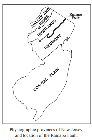
The fault system separates the flat Newark Basin to the east from the mountainous Highlands region to the north and west, said James Davis, associate director for the seismology, geology and tectonophysics division at Columbia’s Lamont-Doherty.
“You can basically see where the Ramapo Fault system is because the topography changes so suddenly,” said Davis.
Even though Pangea separated into multiple plates so long ago, stresses can still build up in the bedrock, and the faults are the likely places where the stress gets released, Davis said — when one side of a fracture slips.
However, it is not clear what causes a fault to slip at a given point in time, Miller said. “Why a fault failed at this time is luck of the draw,” Miller said. “Earthquakes are notoriously hard to predict.”
Rutgers scientists think that this month’s quake occurred along the Flemington Fault.
That squares with what geologists have been learning from their research about New Jersey quakes over the past several decades, Kolawole said. “The Ramapo Fault does not seem to be slipping,” he said. “It’s the secondary faults that seem more susceptible to slip.”
'Evidence of slip!'
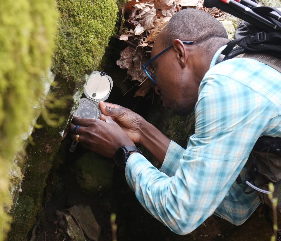
During his most recent visit to Hunterdon County, Kolawole made several other stops at rock outcrops. At one, near a baseball field in High Bridge, a quaint town with narrow streets and old Victorian homes, he pulled a leafing honeysuckle branch away from some granite gneiss to reveal a significant crack.
Out came the Brunton compass again, along with a clear plastic ruler.
“See that?” he said, pointing at the crack, which he could tell was not created by weathering. “Look at that. That is fault rock.”
Then he brushed some loose dirt away from another area where a piece of rock had sheared off. “This damage is the way in which earthquake energy is consumed,” Kolawole said.
He peered closer still. Then he shone a flashlight along the face of the rock, highlighting faint thin striations or grooves — evidence of rocks scraping against each other.
“We might,” he said, “have some evidence of slip!”
This article originally appeared on NorthJersey.com: How NJ earthquake shook local geologists into fervent action

