More severe storms eye tornado-weary central US


Following what was a busy evening for severe weather Tuesday, another round of potent thunderstorms will pivot through the storm-weary Great Plains of the United States into Thursday. AccuWeather meteorologists continue to warn there is the likelihood of multiple tornadoes, as well as many incidents of strong wind gusts, large hail and flash flooding.
 |
Residents, officials and first responders dealing with cleanup in the wake of deadly tornadoes over the weekend are bracing for yet another round of severe weather that includes more tornadoes in what has become a very busy storm zone of the Great Plains and part of the Mississippi Valley over the past week.
Even though the severe weather rounds this week will not be as intense as the period from April 26-27, there are still significant risks to lives and property.
The second storm system of the week triggered a 900-mile-long swath of severe thunderstorms from Nebraska southward to central and western Texas into Wednesday night with powerful straight-line wind gusts, large hail and flash flooding as well as a few tornadoes.
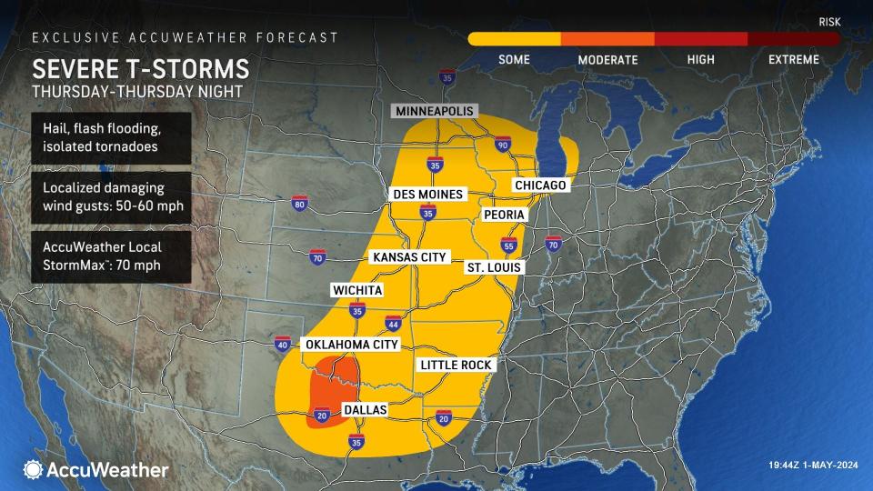
The risk of severe weather will begin to shift eastward Thursday as the storm system moves along. Severe weather will extend from near Minneapolis to just north of Austin, Texas, or along a zone of about 1,000 miles. For parts of the Great Plains, this will mark the third day in a row this week for the potential for severe weather.
 |
"The overall coverage of severe weather on Thursday is likely to be less than that of Wednesday," AccuWeather Senior Meteorologist Geoff Cornish said. Clusters of storms within this zone will pack high winds and hail and perhaps a couple of tornadoes.
AccuWeather meteorologists will also closely monitor the potential for renewed flooding over portions of the Central states.
 |
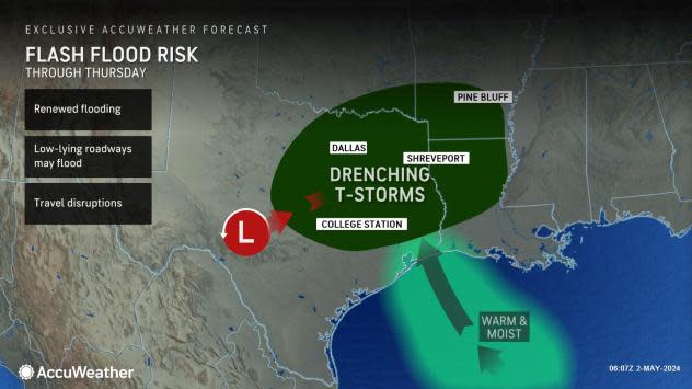
"One area where flash flooding may be heightened is from portions of northeastern Texas and eastern Oklahoma to western and central Arkansas and northern and central Louisiana from Wednesday night to Thursday," AccuWeather Senior Meteorologist Dan Pydynowski said.
This area has seen multiple rounds of thunderstorms packing heavy rainfall. Some areas have seen upwards of 6 inches of rain during April. Shreveport, Louisiana, received 12.41 inches of rain in April, more than two times the historical average for the month of 5.19 inches. Many small streams and secondary rivers in the region have surged out of their banks multiple times in the past month.
Even as the extent of severe weather eases late in the week, it will not be non-existent.
"By Friday into Saturday, a cold front will stall across the southern Plains and lower Mississippi Valley. Gulf moisture will continue to plow into the region with temperatures near to above historical averages, which will support the development of general thunderstorms," AccuWeather Storm Warning Meteorologist Joseph Bauer said.
 |
Pockets of severe weather or at least storms packing heavy rain and gusty winds will extend from Texas to the lower Mississippi Valley, the central Gulf Coast and the Southeastern states.
During the weekend, locally intense thunderstorms will likely erupt along the boundary between dry air and moist air over the central and southern High Plains, which includes West Texas, Bauer said. Sparse storms of this nature can also produce tornadoes and large hail, along with strong wind gusts.
 |
A tornado near Interstate 80 in Lincoln, Nebraska, on April 26, 2024. (Photo credit: Aaron Jayjack) |
"On the horizon, severe weather risks are expected to continue in Tornado Alley early next week as a storm moves into the West Coast over the weekend and emerges into the Plains," Bauer said, "If that storm tracks farther south across the West, it could bring a higher risk for severe weather, but if it trends farther north, this could lead to a lower risk."
As of the end of April 29, the preliminary count of severe weather incidents for 2024 was up to 4,284, with 505 tornadoes, according to the National Oceanic and Atmospheric Administration (NOAA).
 |
The count of filtered severe weather incidents from last weekend is close to 500, with more than 150 tornadoes. NOAA crews will continue to investigate the damage that occurred in the coming days.
