A look at how the hurricane forecast cone will be different in 2024

One of the most well-known products used by the National Hurricane Center will look different in 2024 with the intention of better communicating a cyclone’s wide-ranging threats, as well as taking into account previous forecasting errors.
The cyclone cone, which is a product from a series of forecast circles, is annually updated, but in many years, the changes are more apparent in the details than in the actual display itself.
This year, every forecast period beyond hour 12 is wider than last year’s cone, which factors in accrued errors during past hurricane seasons.
At 36 hours out, track cones will now be 4% larger, which is only about 2-3 miles different from last year.
The most significant changes will be at hours 60 and 120, when the cone will be 9% and 7% wider, respectively.
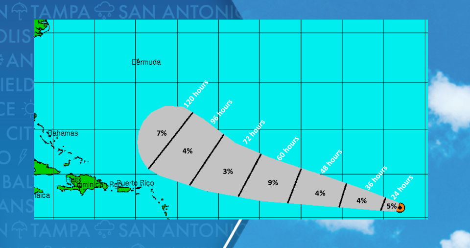
This year’s forecast cone widths are based on error statistics from 2019 to 2023, and while the cone is wider than in previous years, it has seen significant improvements since its first use more than two decades ago.
Hurricane specialists stress that impacts from tropical cyclones occur well outside the cone, and centers of circulation only remain in the cone about 60-70% of the time.
NEW FORECAST CONE TO BE TESTED BY NATIONAL HURRICANE CENTER DURING 2024 SEASON
Starting around Aug. 15, the National Hurricane Center plans to start releasing an experimental forecast cone that will show all related watches and warnings, including alerts issued by local National Weather Service offices.
The maps will undoubtedly be more colorful, but hurricane forecasters hope the display of alerts will help the public focus on the wide-reaching impacts of a cyclone and not the center track line.
Private organizations such as FOX Weather have long had the capability of showing a forecast track with alerts, but the NHC believes its new product will continue to enhance storm messaging.
2024 ATLANTIC HURRICANE SEASON COULD BE AMONG MOST ACTIVE ON RECORD, EXPERTS PREDICT
Additionally, the agency said more Spanish-language products will be released during the 2024 season.
The first named storm typically forms around June 20, with the heart of the season beginning in August and running through early October.
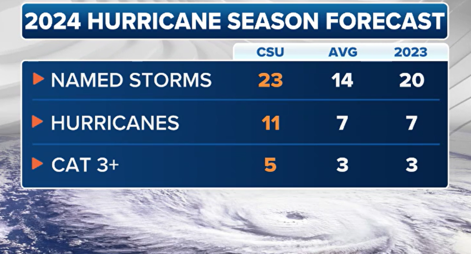
Experts at Colorado State University (CSU) expect the season to be busy and expect the formation of 23 named storms and 11 hurricanes.
Forecasters noted that the outlook was their largest prediction of named storms that CSU has ever issued.
Original article source: A look at how the hurricane forecast cone will be different in 2024

