Severe storms hit Iowa City, Johnson County
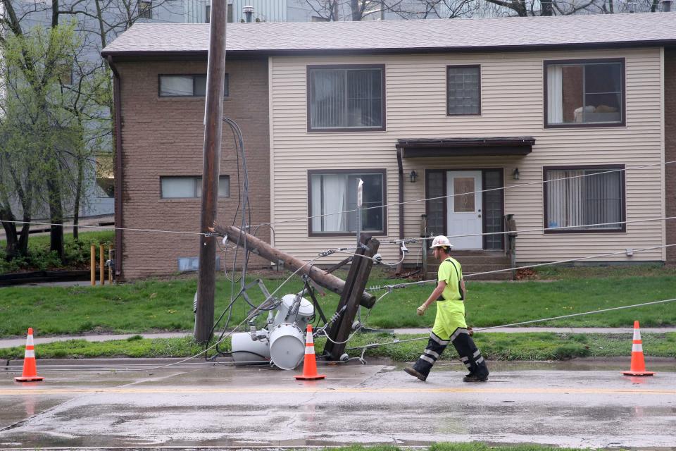
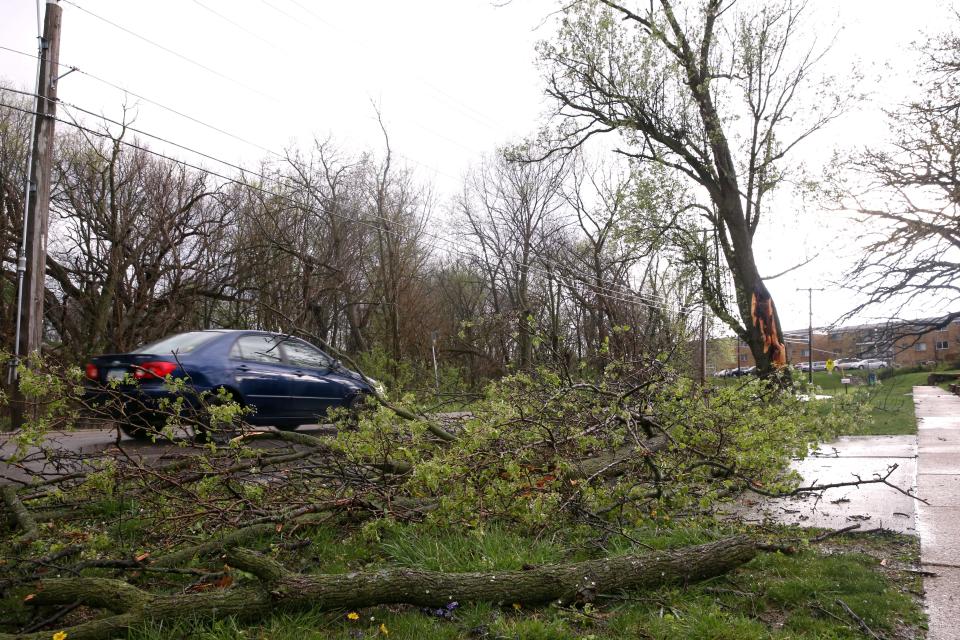
Update (April 17): More than 1,900 residents were briefly without power Tuesday, April 16 after a strong wave of thunderstorms swept through the Iowa City and Coralville area. Intense winds knocked out power lines along North Riverside Drive in Iowa City, temporarily closing the street to traffic between Highway 6 and Park Road.
Bus service in Iowa City and Coralville was temporarily stopped during the storm as well.
University Heights recorded a top wind gust of 53 MPH Tuesday, according to the Quad Cities National Weather Service.
The City of Tiffin reported one inch of rain while Coralville and North Liberty gathered half an inch.
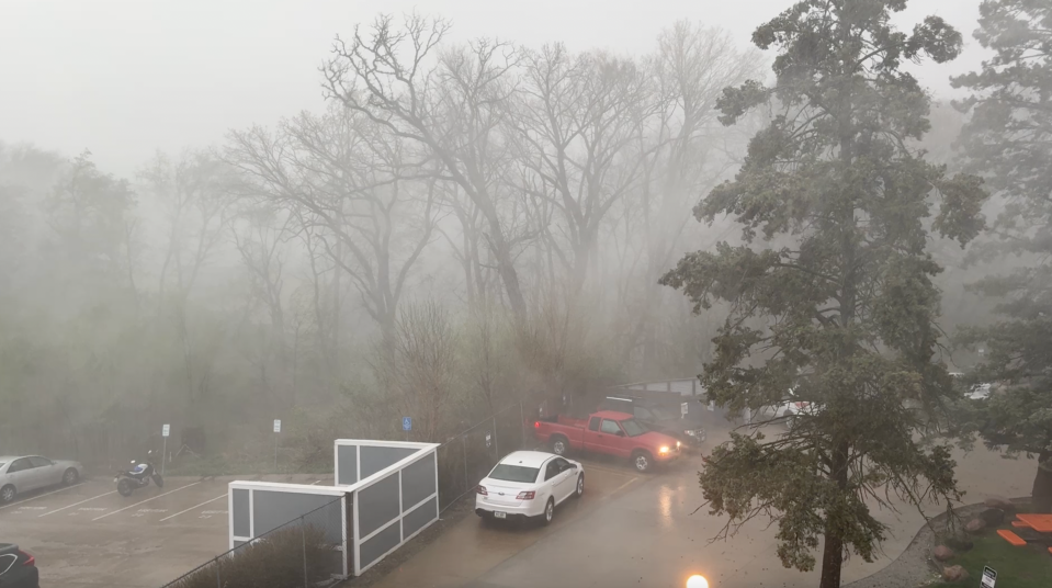
Update: Nearly 1,900 residents in Iowa City and Coralville were without power at 4:45 p.m. Tuesday, April 16, according to MidAmerican Energy Company. A significant string of storms have produced a tornado warning and hail throughout Johnson County.
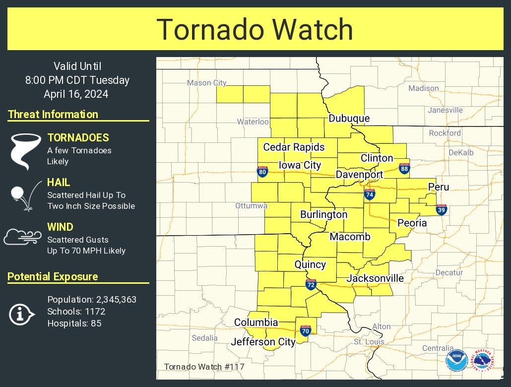
The tornado warning was issued for much of eastern Iowa, including Iowa City until 4:45 p.m. The previous tornado watch remains in effect until 8 p.m.
The watch includes a chance of tornados with scattered wind gusts that could reach 70 MPH. Hail up to two inches in diameter could rain down on Johnson County as well, according to the National Weather Service (NWS) in the Quad Cities.
4:45 p.m.: National Weather Service cancels tornado warning
The Johnson County Emergency Management announced that the National Weather Service has allowed the tornado warning to expire. A severe thunderstorm warning continues for West Liberty and Tipton through 5:15 p.m.
4:30 p.m.: Severe thunderstorm warning
A severe thunderstorm warning has been extended to 5:15 p.m. for Iowa City, as well as other Johnson County towns like Lone Tree, Solon, Hills and Morse. Linn County's severe thunderstorm warning has also been extended in Marion and Mount Vernon.
UPDATE via National Weather Service: A severe thunderstorm capable of producing a tornado was located over the University of Iowa or over Iowa City moving northeast at 45 mph.
— University of Iowa Police Department (@UIowa_Police) April 16, 2024
4:15 p.m.: Tornado warning in Iowa City
A tornado warning was issued for Iowa City, Mount Vernon, and Lisbon until 4:45 p.m. The rotation started near Iowa City and was moving northeast. KCRG reported on their television broadcast that a radar-indicated tornado had been spotted along Dodge Street just north of the Iowa City Community School District building near Interstate 80.
The rotation was headed toward Solon.
Iowa City and Coralville buses are now temporarily out of service.
The University of Iowa Police Department, in a social media post at 4:30 p.m., encouraged residents to take immediate shelter: "Go to the lower, innermost room of your building away from windows and assume a tornado safety position. Do not go to large open rooms such as cafeterias, gymnasiums, or auditoriums," the post said on X.com.
Tornado Warning including Iowa City IA, Mount Vernon IA and Lisbon IA until 4:45 PM CDT pic.twitter.com/ZqddGrWx79
— NWS Quad Cities (@NWSQuadCities) April 16, 2024
3:55 p.m.: Severe thunderstorm warning in Iowa City
A severe thunderstorm warning has been issued for much of Johnson County until 4:30 p.m., including Iowa City, North Liberty, Hills, Cedar Rapids, and Marion. The storm cell, according to the National Weather Service, could produce winds up to 60 MPH and quarter-sized hail. The storm system also has the potential to produce a tornado.
Severe Thunderstorm Warning including Cedar Rapids IA, Iowa City IA and Marion IA until 4:30 PM CDT pic.twitter.com/vNwc19RLgt
— NWS Quad Cities (@NWSQuadCities) April 16, 2024
2:59 p.m.: 70 MPH wind gusts in northwest Johnson County, headed toward Marion
A severe thunderstorm warning has been issued for Cedar Rapids, Hiawatha, and Marion through 3:15 p.m. The National Weather Service said the storm cell, which has produced wind gusts of 70 MPH, extends from just south of Oxford north to Lamont.
The National Weather Service also issued a severe thunderstorm warning for much of Johnson County that expires at 3:45 p.m. The cell, which could produce 60 MPH winds and pea-sized hail, will impact Iowa City, Solon, Tipton and Mount Vernon.
Severe Thunderstorm Warning including Iowa City IA, Anamosa IA and Mount Vernon IA until 3:45 PM CDT pic.twitter.com/BpbzudkN36
— NWS Quad Cities (@NWSQuadCities) April 16, 2024
When will the thunderstorms arrive?
Multiple storms will track east and northeast across the area.
Johnson County residents can expect severe thunderstorms between 2:30 p.m. and 4:30 p.m. The onset of severe weather potential will persist through roughly 9 p.m.
The tornado watch includes Johnson, Linn, Benton, Chickasaw, Delaware, Fayette, Iowa, Lee, Muscatine, Washington, Buchanan, Cedar, Clayton, Des Moines, Clinton, Dubuque, Floyd, Henry, Jackson, Jones, Scott, Jefferson, Keokuk, Louisa, and Van Buren counties.
The NWS issued a tornado watch in several central Iowa counties that will remain in effect until 6 p.m.
⚠️Midday Update!
Here is the forecast onset timing of severe weather potential from west to east across the area. Once the severe potential begins, there will be multiple rounds of storms over several hours into the evening. pic.twitter.com/V7To3rz22D— NWS Quad Cities (@NWSQuadCities) April 16, 2024
The NWS defines a tornado as a violently rotating column of air extending from the base of a thunderstorm to the ground, capable of destroying structures, uprooting trees and hurling objects through the air. When indicated by radar or spotted by spotters, a tornado warning is issued, prompting immediate seeking of safe shelter in the affected area, even if no tornado watch is in effect.
The NWS, suggests staying vigilant and aware of any active watches, as tornado watches can quickly turn to a warning.
STRONG Tornado Lofts Silo and throws it across the road outside of Salem, IA a short time ago @NWSQuadCities @RadarOmega @FoxWeather #IAwx pic.twitter.com/jA4yPgtDOv
— Brandon Copic (@BrandonCopicWx) April 16, 2024
1245pm CDT Radar Loop:
Storms continue to develop and lift northeast into IA and northeast MO, with several warnings issued with the initial cells. This 1st round will continue through 5pm through the region. Another round is possible behind this 1st round this evening. pic.twitter.com/R9usTpLVzK— NWS Quad Cities (@NWSQuadCities) April 16, 2024
How do you stay safe during a tornado?
National Weather Service said that during a tornado, you should:
Get as low as possible. A basement below ground level or the lowest floor of a building offers the greatest safety.
Put as many walls between yourself and the outside as possible
Avoid windows at all costs.
A tornado watch has been issued for parts of Illinois, Iowa, Missouri and Wisconsin until 8 PM CDT pic.twitter.com/ZJxwyOO1S4
— NWS Quad Cities (@NWSQuadCities) April 16, 2024
If you live in a house with no basement or an apartment building, safety tips from the National Weather Service include:
Avoid windows.
Go to the lowest floor and take shelter in a small center room, like a bathroom or closet, under a stairwell, or in an interior hallway with no windows.
Crouch as low as possible to the floor, facing down; and cover your head with your hands.
Metal bathtubs offer a shell of protection, but not plastic or fiberglass. If your bathtub is plastic or fiber glass, cover yourself with thick padding like a mattress or blankets to protect against falling debris.
Tornado warned storm across the northwest part of Lee County IA... ⚠️ https://t.co/Sp0WPptCAh
— NWS Quad Cities (@NWSQuadCities) April 16, 2024
What should you do if you’re driving during a tornado warning?
If you’re driving, particularly on interstates or highways, do not try to outrun a tornado.
If you are driving in an area with a tornado warning, you should look for ways to safely get off the road and out of your vehicle — preferably by seeking refuge in a sturdy building.
As a last resort, lie flat in the nearest depression, ditch or culvert and cover your head with your arms.
What’s the difference between a tornado watch and a tornado warning?
A Tornado watch is issued when conditions are favorable for the development of tornadoes in and close to the area, according to NWS. They are usually issued for 4 to 8 hours and take effect several hours before storms may arrive.
However, a tornado warning is issued when a tornado is imminent. Warnings can be triggered by reports from trained weather spotters or indications on radar. When a tornado warning is issued, you should seek safe shelter immediately.
Des Moines Register reporters Victoria Reyna-Rodriguez and Kate Kealey contributed to this report.
Jessica Rish is an entertainment, dining and business reporter for the Iowa City Press-Citizen. She can be reached at JRish@press-citizen.com or on X, formerly known as Twitter, @rishjessica_
This article originally appeared on Iowa City Press-Citizen: Severe weather, radar-indicated tornado impact eastern Iowa

