Dry weather prevails tonight & most of Monday; Showers/storms return Tuesday
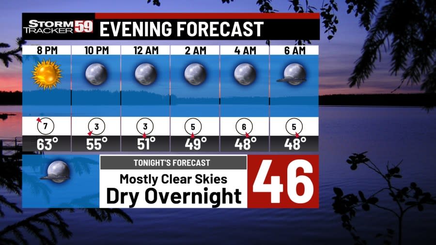
Tonight, we end Mother’s Day with a calm evening under mostly clear skies. High pressure from this afternoon will stick around tonight, keeping us with mostly clear skies for the rest of tonight! Overnight lows will be on the chilly side as they drop into the 40s.

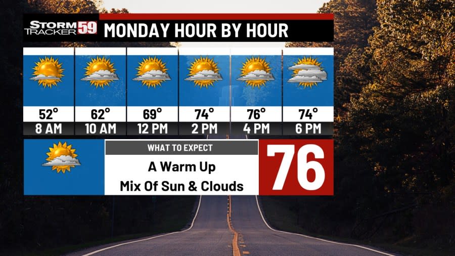
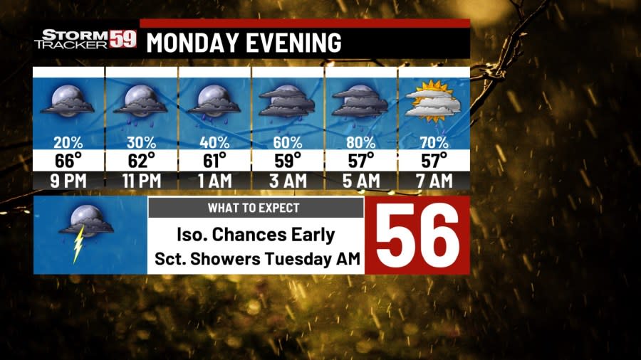
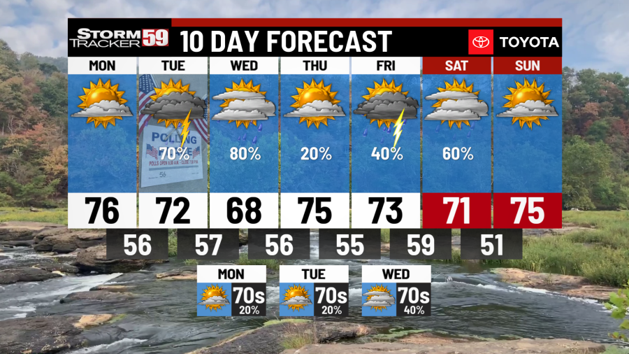
Monday will start with a dry morning so the trip to work/school looks like a piece of cake. Lunch plans also shouldn’t be that impacted, outside of a few clouds building in. During the second half of Monday, as temps climb into the 70s, we bring in the chance for a few showers, primarily during the late evening through the overnight hours.
Election Day begins with morning showers at times so be mindful of wet roadways. A rain jacket will help with the occasional rain shower or two through lunchtime, as temps make their way into the 70s. The afternoon and evening look better for chances of scattered showers, and even a few thunderstorms, so keep the rain jackets around as you make your way to the polls!
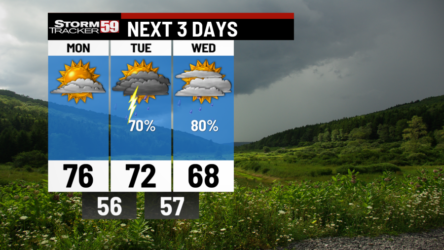
Wednesday continues our soggy pattern with more scattered showers thanks to a passing low pressure system. The morning through the late afternoon holds the best chances for showers so look out for slick travel conditions and heavy downpours while also keeping our temps cooler in the 60s. Our low will move out overnight, bring in drier weather behind it.
Thursday provides us mostly with a break as we wait for our next system to arrive on Friday. As clouds break apart in the morning, we’ll see the chance for some patchy fog in the morning. A mix of sun and clouds will follow for the remainder of the day, though an isolated, stray shower can’t be completely ruled out. Expect temps to be in the 70s.
Photos of the Northern Lights in our region
Friday morning sees building clouds and the chance for a hit or miss shower in the morning. The afternoon through the overnight sees better chances once again as another low pressure system crosses. Temps will stay a few degrees cooler than Thursday with many in the upper 60s and low 70s.
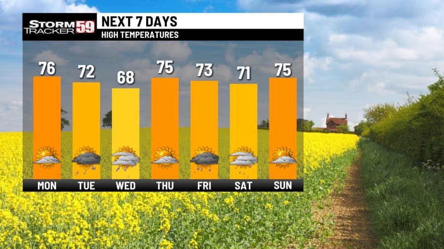
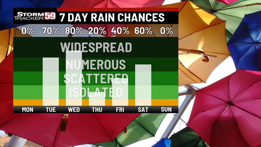
Saturday morning, at least, looks wet with scattered showers likely. Afternoon plans will not look the best with the occasional shower or two still lingering around. As our low crosses in the evening, we’ll start to see conditions improve as rain chances decrease. Despite the clouds and rain, temps will still make it back into the 70s.
In your extended forecast, showers will likely end by Saturday night as another high pressure system builds in. Sunday so far is looking like our best chance for any dry time during the weekend forecast. By next Monday, rain chances look to return and stretch into next Wednesday at most. Temps will be in the 70s during this time!
We are in spring forest fire season in West Virginia – this means don’t burn between 7 AM and 5 PM through May 31st. Low humidity values during the daytime, along with breezier and warmer conditions will at times increase the fire threat, hence the burn ban during most of the daytime. Follow all regulations or be faced with potential consequences, such as fines!

TONIGHT
Mostly clear skies. Dry end to Mother’s Day! Lows in the 40s.
MONDAY
Sunny/dry start. PM rain chances. Highs in the 70s.
ELECTION DAY
A few AM showers. PM sct. showers and storms. Highs in the 70s.
WEDNESDAY
Sct. showers. Overnight clearing. Cooler. Highs in the 60s.
THURSDAY
Partly cloudy. Lingering Iso. rain chance. Highs in the 70s.
FRIDAY
AM building clouds/showers. Sct. showers/storms PM. Highs in the 70s.
SATURDAY
Showers & storms possible. Overnight clearing. Highs in the 70s.
SUNDAY
Mix of sun & clouds. Staying warm. Highs in the 70s.
MONDAY
Partly cloudy. Chance for showers. Highs in the 70s.
TUESDAY
AM break. PM chance for showers. Highs in the 70s.
WEDNESDAY
Rain showers early. Overnight clearing. Highs in the 70s.
For the latest news, weather, sports, and streaming video, head to WVNS.

