Dry Time: Sunny days ahead help flood impacted communities clean up
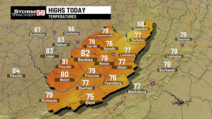
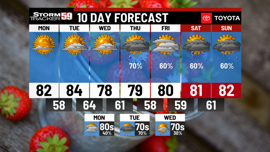
Monday will be a beautiful day with high pressure in full control. Blue skies and temps rising from the upper 50s of the morning into the low 80s by the afternoon. Southeast winds will keep our eastern counties cooler in the upper 70s as usual but a lovely day all around. A few fair weather clouds mid afternoon will help make for a stunning sunset tonight. Lows drop into the upper 50s under clear skies.
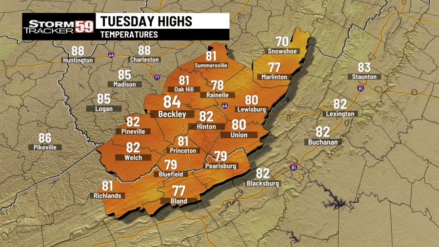
Tuesday is another gorgeous day with mostly clear skies. A few clouds roll high in the sky for the afternoon but nothing that will hurt temps. Highs rise into the low to mid 80s with humidity levels in the comfy zone. A light breeze is just the cherry on top. A mild night with overnight lows in the low 60s.
Wednesday starts nice but an advancing cold front looks to bring clouds by mid day. Highs still manage the upper 70s but the 80s will be just out of reach as clouds continue to build in for the afternoon. Scattered showers are possible towards the evening with a better chance into the overnight. Southwest winds and cloudy skies keep overnight lows in the upper 50s low 60s.
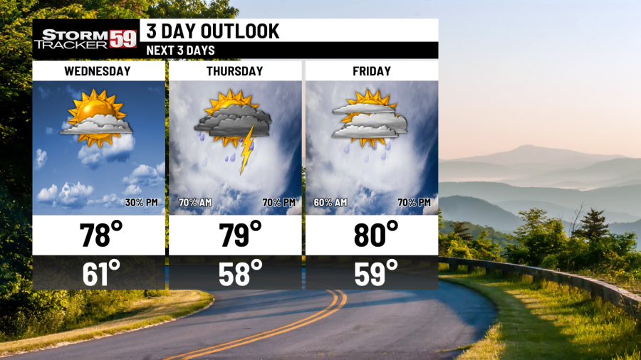
Thursday is shaping up to be a soggy day. Off and on showers roam from west to east throughout the day. A few breaks but a gloomy, humid feel as daytime highs push into the upper 70s and low 80s. Heavier rain is expected Thursday evening into Friday morning.
Friday scattered showers will certainly impact Memorial Day Weekend travelers. Showers will come and go with heavier rain for the late afternoon and early evening. Highs are still above average in the low 80s.
Saturday, you guessed it, scattered showers at times will keep the weekend festivities on the soggy side. Temps still manage to push into the 80s. A few thunderstorms in the late afternoon and evening will bring heavy rain which may lead to runoff issues and high water concerns.
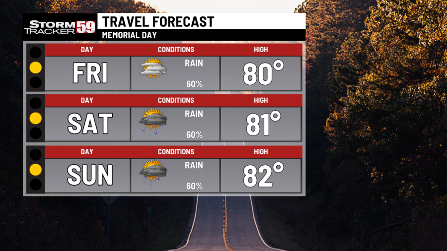
Sunday we’re still in a wet pattern as moisture continues to be thrown our way via our jet stream. Another day with off and on showers will keep rivers running high. A few thunderstorms are possible in the evening with heavy rain. Highs still manage the low 80s.
Memorial Day, Monday will be much warmer than last year but soggier too. Showers continue to push in from time to time. A few breaks early, but afternoon thunderstorms will certainly rain on your BBQ. Highs still feeling summer-like with the low 80s.
In your extended forecast, like a cruel joke, we begin to dry out heading into the first week of June. For those looking for the summer heat and humidity, however, will have to wait a little while. Temps are trending cooler for June but still within normal average in the low 70s.
MONDAY
Sun-sational! Highs in the uper 70s/low80s.
TUESDAY
Sunshine & warm! Highs in the low 80s.
WEDNESDAY
Dry start, building clouds, PM showers. Highs in the upper 70s.
THURSDAY
Soggy run. Sct. showers. Highs in the upper 70s.
FRIDAY
Off & on showers. Highs in the upper 70s/low 80s.
SATURDAY
Scattered showers, mostly cloudy. Highs in the low 80s.
SUNDAY
Morning showers, PM t-storms. Highs in the low 80s.
MEMORIAL DAY, MONDAY
More rain, warm. Highs in the low to mid 80s.
TUESDAY
Mostly cloudy, Sct. showers/t-storms. Highs in the mid to upper 70s.
WEDNESDAY
Drying out, iso. shower. Partly sunny. Highs in the low 70s.
THURSDAY
Sunshine & comfy. Highs in the low 70s.
Copyright 2024 Nexstar Media, Inc. All rights reserved. This material may not be published, broadcast, rewritten, or redistributed.
For the latest news, weather, sports, and streaming video, head to WVNS.

