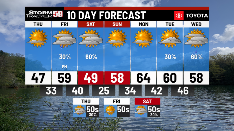
Cooler Thursday, rain chances return ahead
Tonight features mostly clear skies and it’s a COLD night on the way with temperatures dropping into the low to mid 20s. With a breeze switching to coming out of the north that will weaken but still persist overnight, wind chill values will drop into the teens and single digits – definitely a night to bring any plant you happen to have outside inside. Gusts up to 25 mph are still possible.

Thursday features more sunshine but with an area of high pressure moving into the Great Lakes from Canada, we’ll pick up a northwest breeze. That breeze will push temperatures down into the mid to upper 40s for highs, so it’s a colder day but at least the wind won’t be quite as bad, with wind gusts no higher than 15 mph expected. With very dry conditions still in place, please do not burn period until this weekend. Clouds will begin to populate late in the day, with partly cloudy skies expected overnight as signs from our next approaching system begin to show. The clouds and a southeast breeze will keep temperatures from falling quite as much, with lows around freezing.

Friday brings rain showers back to the region, especially for the afternoon, as a trough crosses. Although a good setup for cold air damming is expected with high pressure to our northeast over Canada, temperatures even in the highest mountain spots should remain just warm enough for showers to remain as rain, however highs on the eastern side of the mountains will struggle to reach into the 40s. For the lowlands, we won’t be affected by cold air damming, with highs making a run deep into the 50s – a few 60s in our western counties is a good bet! We will see a big variety in temperatures for highs, ranging from near 60 in the lowlands down to the low to mid 40s in the highlands. Showers will continue into the overnight hours, with lows around 40.

Saturday keeps rain showers likely through the morning in what will begin as a dreary, gloomy and cold day with a northwest breeze in place. Rain shower chances will become more isolated in the afternoon, though a sprinkle or two can’t still be ruled out. High temperatures will be in the upper 40s in the lowlands and low 40s in the mountains but with a northwest breeze that could gust to 25 mph, wind chill values in the 30s will make for a chilly afternoon.
Sunday brings mostly sunny skies into the region with high pressure overhead shifting to our east by the afternoon, which will warm us up as a return flow shapes with a southwest breeze. This will push high temperatures into the upper 50s with hardly a cloud in the sky. At least the wind will relax!
Monday provides mostly sunny skies once again and high temperatures pushing into the 60s – it’s going to feel great outside! Our next system will begin to approach late in the day, with clouds on the increase and showers will then be likely heading into the next day.
Tuesday sees mostly cloudy skies and a few showers by the afternoon. Rain chances will be greatest overnight into Wednesday, with high temperatures warm once again with a stout southerly breeze around 60 degrees.

Wednesday continues the mild but unsettled pattern, with a few showers continuing. Showers will be less numerous and high temperatures will make a run once again at 60 degrees.
Looking ahead in your extended forecast, we’ll see rain showers on Thursday with a coastal low riding up the east coast providing ample chances for showers. High temperatures will be seasonal Thursday in the 50s. High pressure returns on Friday with highs back up into the 60s under mostly sunny skies with more chances for rain arriving on Saturday. We’ll see high temperatures dip back into the 50s as a result.
Help us with our growing community of weather photos with #weathertogether. Head to our website and search for the ‘Weather together’ tab and upload your photos of weather going on around our region.
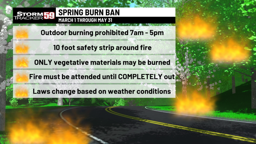
We are in spring forest fire season in West Virginia – this means don’t burn between 7 AM and 5 PM through May 31st. Low humidity values during the daytime, along with breezier and warmer conditions will at times increase the fire threat, hence the burn ban during most of the daytime. Follow all regulations or be faced with potential consequences, such as fines! In Virginia, the spring fire season continues through April 30th – don’t burn before 4 PM.
TONIGHT
Mostly clear, breezy & cold! Lows in the low 20s with wind chill values in the teens and single digits.
THURSDAY
Mostly sunny. Highs in the mid to upper 40s. Not nearly as breezy!
FRIDAY
Rain showers likely by the late afternoon. Quite a variance in temperature, with highs in the upper 50s in the lowlands but only in the low to mid 40s in the highlands.
SATURDAY
Gloomy start with showers likely. Afternoon clearing. Highs in the upper 40s.
SUNDAY
Mostly sunny. Highs in the upper 50s.
MONDAY
Mostly sunny. Highs in the low to mid 60s.
TUESDAY
Rain showers likely, especially for the afternoon. Highs near 60.
WEDNESDAY
Showers likely once again. Highs near 60.
THURSDAY
Rain likely. Highs in the 50s.
GOOD FRIDAY
Sunny. Highs in the 50s.
SATURDAY
Rain chances return. Highs in the 50s.
For the latest news, weather, sports, and streaming video, head to WVNS.

