Fast-building, fast-moving storms move across St. Louis region
ST. LOUIS – The St. Louis area is on the receiving end of another round of powerful storms, bringing with them more severe weather threats, including possible tornadoes, rain, hail, and strong winds. This follows several tornado-warned storms around the region Wednesday morning and early afternoon.
General Timeline
The greatest threats for severe weather in the St. Louis metro are between the 6 p.m. and 8 p.m. hours. The biggest storm threats are expected to clear the region and head east toward Illinois by 8 p.m. The worst of it should be out of our area completely by 10 p.m.
This next system of severe weather will mostly impact communities south of the Interstate 70 corridor. It could be more intense along the Interstate 44 corridor.
Severe weather will build up in Mid-Missouri around 4 p.m., first expected to approach Phelps, Crawford and Franklin counties, along with other nearby areas.
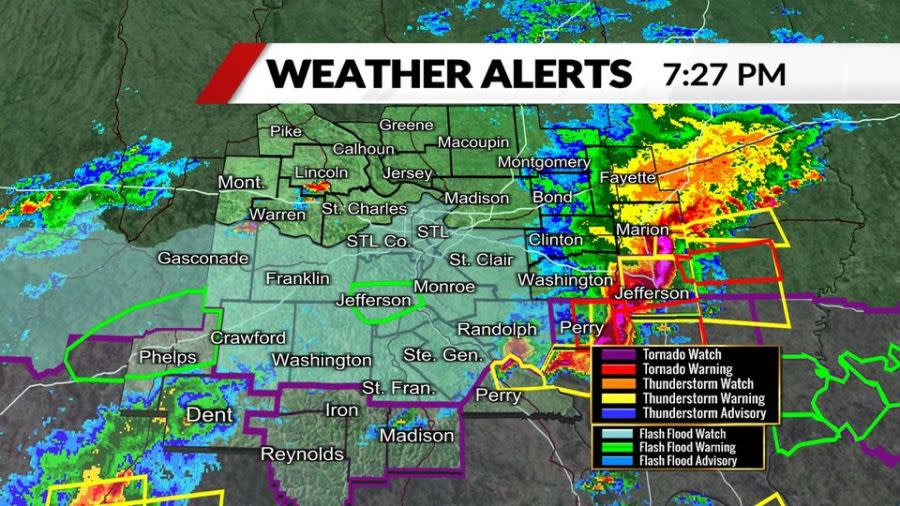
St. Louis radar: See a map of current weather here
Radars indicate a more intense round of storms could hit more south of the St. Louis metro. Severe weather threats are heading east, likely between St. Genevieve and Cape Girardeau from the 6 to 9 p.m. hours.
It’s possible the threat will end earlier in St. Louis but linger longer into the evening over southern Missouri and southern Illinois. Flash flooding is also a concern for southeastern Missouri and southern Illinois.
Download the FOX 2 News and Weather Apps to stay on top of ever-changing conditions.
For the latest news, weather, sports, and streaming video, head to FOX 2.

