The 2024 hurricane season forecasts are alarming. Can history teach us what to expect?
All the early predictions are calling for a very active 2024 Atlantic hurricane season.
The combination of La Niña and record warm water temperatures isn't good when it comes to tropical cyclones. La Niña , unlike its El Niño counterpart, doesn't have the wind shear that tears apart developing storms.
Warm water temperatures provide the fuel storms need to develop and strengthen.
Can history give us an idea of what to expect this year? Forecasters with Colorado State University looked at five "analog" years based on above-normal sea surface temperatures and the presence of La Niña.
2024 Atlantic hurricane season forecasts
So far, every prediction for the 2024 Atlantic hurricane season calls for an extremely active season.
AccuWeather is predicting this season has the potential to break the all-time record of 30 named storms in one season.
20-25 named storms
8-12 hurricanes
4-7 major hurricanes
4-6 direct U.S. impacts
CSU's 2024 Atlantic hurricane season forecast calls for:
23 named storms
11 hurricanes
5 major hurricanes
Dr. Ryan Truchelut, chief meteorologist at WeatherTiger, predicted the 2024 season has a 50-50 shot of landing in the ranges of:
20-24 tropical storms
9-12 hurricanes
4-7 major hurricanes
Truchelut works with the USA TODAY Network-Florida to provide the latest storm information Florida residents need.
Start getting ready: 2024 will be a busy hurricane season in Florida. Here's what you should start doing now
How many tropical cyclones does an average hurricane season have?
Based on a 30-year average from 1991 to 2020, the typical Atlantic hurricane season has 14 named storms, seven hurricanes, and three major hurricanes.
A major hurricane is a Category 3 or higher storm, and a storm is classified as a Category 3 when maximum sustained winds are at least 111 mph, according to NOAA.
The first named storm typically forms in mid-to-late June, the first hurricane tends to form in early to mid-August, and the first major hurricane forms in late August or early September.
CSU compares 2024 hurricane season to five other years
CSU's five analogs for the 2024 Atlantic seasonal #hurricane forecast are: 1878, 1926, 1998, 2010, and 2020. Analogs are selected based on likely #LaNina and above-normal sea surface temperatures in tropical Atlantic for August-October. pic.twitter.com/nUertvMrW7
— Philip Klotzbach (@philklotzbach) April 4, 2024
"CSU's five analogs for the 2024 Atlantic seasonal #hurricane forecast are: 1878, 1926, 1998, 2010, and 2020," said Philip Klotzbach, a meteorologist at CSU who specializes in Atlantic basin seasonal hurricane forecasts.
"Analogs are selected based on likely #LaNina and above-normal sea surface temperatures in tropical Atlantic for August-October," he posted on X, formerly known as Twitter.
Here's what those five years looked like.
2020: Record-breaking season with 30 named storms. See Florida impacts.
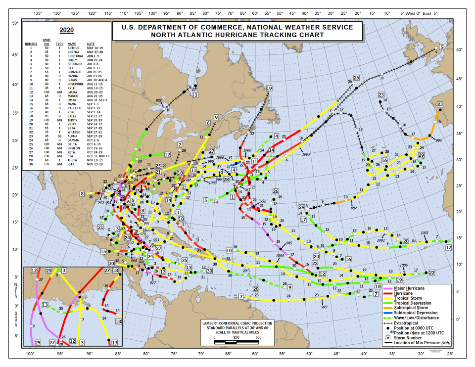
The extremely active 2020 Atlantic hurricane season hit a record with 30 named storms and 11 storms that made landfall in the continental United States, according to the National Hurricane Center.
"The 2020 season got off to an early and rapid pace with a record nine named storms from May through July, and then quickly exhausted the 21 names on the Atlantic list when Tropical Storm Wilfred formed on Sept. 18," the National Weather Service said.
"For only the second time in history, the Greek alphabet was used for the remainder of the season, extending through the ninth name in the list, Iota." It was the last year the Greek alphabet was used. A supplemental list will be used if all 21 names are used in a year.
Tropical Storm Arthur, May 16-19
Maximum sustained winds: 57 mph
The system that would later develop into Arthur brought heavy rainfall across the Florida Keys and Southeast Florida. Fort Lauderdale reported storm total rainfall of 9.95 inches. It became a tropical storm about 165 miles east-northeast of Cape Canaveral.
On 17 May in Volusia County, there were 70 water rescues due to these rip currents.
Tropical Storm Bertha, May 27-28
Maximum sustained winds: 51 mph
Bertha brought minor storm surge to Northeast Florida.
Up to 15 inches of rain fell across Southeast Florida from the disturbance that would later become Bertha.
Tropical Storm Cristobal, June 1-9
Maximum sustained winds: 57 mph
Eleven of 13 tornadoes occurred in Florida on June 6-7 within Cristobal’s outer rainbands.
Panama City Beach reported sustained winds of 40 mph.
Minor coastal flooding of 1 to 3 feet was reported along portions of the Florida Panhandle.
Stuart reported 15.20 inches and Madison recorded 13.55 inches of rainfall from June 7 through June 9.
Tropical Storm Dolly, June 22-24
Maximum sustained winds: 46 mph
Tropical Storm Edouard, July 4-6
Maximum sustained winds: 46 mph
Tropical Storm Fay, July 9-11
Maximum sustained winds: 57 mph
What would later become Fay came ashore between Panama City and Apalachicola but wasn't organized enough at the time to be considered a tropical depression.
Tropical Storm Gonzalo, July 21-25
Maximum sustained winds: 63 mph
Hurricane Hanna, July 23-26
Maximum sustained winds: 92 mph
What would later become Hanna brought 3 to 6 inches of rain to South Florida and the Keys, with 7.44 inches recorded in Key West.
Before Hanna became a tropical cyclone, rough surf contributed to the drowning of a 33-year-old man in Walton County after he rescued his 10-year-old son.
Hurricane Isaias, July 30-Aug. 4
Maximum sustained winds: 92 mph
The center of Isaias passed within 40 miles of West Palm Beach and Fort Lauderdale.
The strongest sustained winds were 48 mph at Stuart Beach.
There was minor beach erosion on top of the abnormally high tide. About 3,000 customers lost power, most of them in Palm Beach County.
Tropical Storm Josephine, Aug. 11-16
Maximum sustained winds: 46 mph
Tropical Storm Kyle, Aug. 14-15
Maximum sustained winds: 51 mph
Major Hurricane Laura, Aug. 20-29
Maximum sustained winds: 149 mph
The Key West International Airport saw sustained winds of 39 mph.
Hurricane Marco, Aug. 21-25
Maximum sustained winds: 74 mph
Apalachicola reported 13.17 inches.
Tropical Storm Omar, Aug. 31-Sept. 5
Maximum sustained winds: 40 mph
Hurricane Nana, Sept. 1-3
Maximum sustained winds: 74 mph
Hurricane Paulette, Sept. 7-22
Maximum sustained winds: 103 mph
Tropical Storm Rene, Sept. 7-14
Maximum sustained winds: 46 mph
Hurricane Sally, Sept. 11-17
Maximum sustained winds: 109 mph
Sally’s winds, storm surge, and excessive rainfall caused extensive damage across the Florida Panhandle. Thousands of structures were damaged in Escambia and Santa Rosa counties by strong wind and storm surges, and about 50 structures were destroyed.
Sally produced sustained hurricane-force winds across the extreme western part of the Florida Panhandle where it made landfall near Cutler Bay.
Storm surge inundation of 2 to 4 feet above ground level occurred along the coast of the Florida Panhandle east of Pensacola to the Big Bend, although some areas near Apalachee Bay experienced even higher water levels.
The largest storm surge impacts occurred in the Perdido Key area and along parts of Pensacola and Escambia Bays, where numerous structures were significantly damaged. The storm surge moved numerous large boats and barges onto land, and a section of the U.S. 98 Three Mile Bridge over Pensacola Bay collapsed when a construction barge struck the bridge.
A maximum total of 24.88 inches was measured just west of Naval Air Station Pensacola. A secondary maximum occurred over the Florida Keys, with some areas receiving a foot or more of rain. A total of 12.88 inches of rain was measured in Islamorada on Lower Matecumbe Key.
Of 16 reported tornadoes, one was in Florida. The EF-0 tornado was on the ground for nearly 10 miles, crossing from Calhoun County into Jackson County.
A 27-year-old man drowned after he left his Riola Place neighborhood of Pensacola on Perdido Bay in a 12-foot jon boat.
Media reports and the medical examiner indicated a 45-year-old woman drowned near Innerarity Point after her vehicle was overtaken by rising storm surge.
Major Hurricane Teddy, Sept. 12-23
Maximum sustained winds: 138 mph
Tropical Storm Vicky, Sept. 14-17
Maximum sustained winds: 51 mph
Tropical Storm Beta, Sept. 17-22
Maximum sustained winds: 63 mph
Tropical Storm Wilfred, Sept. 17-21
Maximum sustained winds: 40 mph
Subtropical Storm Alpha, Sept. 17-19
Maximum sustained winds: 51 mph
Hurricane Gamma, Oct. 2-6
Maximum sustained winds: 74 mph
Major Hurricane Delta, Oct. 4-10
Maximum sustained winds: 138 mph
A 19-year-old woman and a 49-year-old man drowned in rip currents while the hurricane’s outer bands were nearby.
Major Hurricane Epsilon, Oct. 19-26
Maximum sustained winds: 115 mph
A 27-year-old man drowned in Epsilon-induced rip currents in Daytona Beach.
Major Hurricane Zeta, Oct. 24-29
Maximum sustained winds: 115 mph
Tropical-storm-force winds were reported across the Florida Panhandle, with the highest sustained winds 47 mph at t Santa Rosa Sound.
About 10,000 customers lost power from gusty winds that also downed trees in Holmes and Walton counties.
Beach erosion was reported in Bay County.
Major Hurricane Eta, Oct. 31-Nov. 13
Maximum sustained winds: 149 mph
Eta first made landfall in the Florida Keys near Lower Matecumbe Key with sustained winds of 63 mph.
Torrential rain was reported over South Florida. The highest recorded was 20.74 inches occurred in Broward County in Pembroke Pines. Other amounts included: 16-18 inches in Miramar; Miami-Dade County, 14.12 inches; and 13.40 inches in North Miami.
A second landfall was made near Cedar Key with sustained winds of 51 mph.
A 65-year-old man was electrocuted in floodwaters at his home in Bradenton Beach.
In Pinellas County, 33 people were rescued from flooded homes and stalled vehicles in Pass-a-Grille.
The storm continued to weaken as it moved across the state, entering the Atlantic just north of the Florida-Georgia line.
Eta produced storm surge inundation levels of 3 to 4 feet above ground level in the Tampa Bay area.
There was one EF-0 tornado reported in Manatee County that caused minor damage.
Tropical Storm Theta, Nov. 10-15
Maximum sustained winds: 69 mph
Major Hurricane Iota, Nov. 13-18
Maximum sustained winds: 155 mph
2010: 19 named storms, 5 were major hurricanes. See Florida impacts.
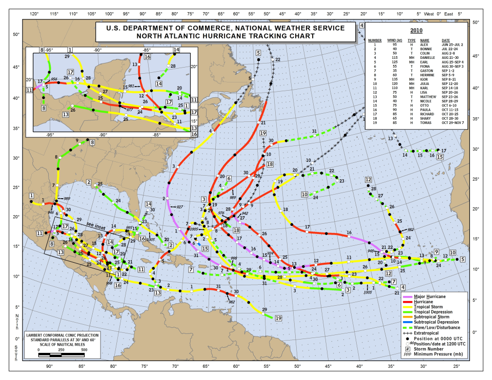
"While the number of cyclones, hurricanes, and major hurricanes was enough to put fear into coastal residents from the Virgin Islands to the Canadian Maritimes, steering patterns and other fortunate ocean/atmosphere interactions, not to mention dumb luck, kept some of the potentially devastating storms at sea, literally and figuratively," the National Weather Service said in its summary of the 2010 season.
"Media coverage will likely focus on a busy season that was missing in action; indeed, major population centers around the United States Gulf and Eastern Seaboard saw virtually no impact, save for a scraping along the Mid Atlantic and Northeast U.S. coastline by Hurricane Earl in late August."
The reason for the high number of tropical cyclones was attributed to "the combination of high upper oceanic heat content across much of the basin, and a rapidly developing La Niña in the eastern tropical Pacific."
Hurricane Alex, June 25-July 2
Maximum sustained winds: 109 mph
Tropical Storm Bonnie, July 22-24
Maximum sustained winds: 46 mph
Bonnie made landfall along the southeastern coast of Florida near Elliot Key with maximum winds of 40 mph. Bonnie became a tropical depression just a few hours later over the Everglades about midway between Miami and Naples.
Tropical Storm Colin, Aug. 2-8
Maximum sustained winds: 57 mph
Major Hurricane Danielle, Aug. 21-30
Maximum sustained winds: 132 mph
One death was associated with Danielle. A 47-year-old man drowned in rough surf in Satellite Beach. Lifeguards also rescued 68 people in Brevard and several dozen in Volusia counties from rough surf or rip currents.
Major Hurricane Earl, Aug. 25-Sept. 4
Maximum sustained winds: 143 mph
A 14-year-old girl died due to the high surf in northeastern Florida.
Tropical Storm Fiona, Aug. 30-Sept. 3
Maximum sustained winds: 63 mph
Tropical Storm Gaston, Sept. 1-2
Maximum sustained winds: 40 mph
Tropical Storm Hermine, Sept. 5-9
Maximum sustained winds: 69 mph
Major Hurricane Igor, Sept. 8-21
Maximum sustained winds: 155 mph
Major Hurricane Julia, Sept. 12-20
Maximum sustained winds: 138 mph
Major Hurricane Karl, Sept. 14-18
Maximum sustained winds: 126 mph
Hurricane Lisa, Sept. 20-26
Maximum sustained winds: 86 mph
Tropical Storm Matthew, Sept. 23-26
Maximum sustained winds: 57 mph
Tropical Storm Nicole, Sept. 28-29
Maximum sustained winds: 46 mph
Areas of heavy rainfall were reported over portions of southern Florida. The maximum reported amount in Florida was 12.64 inches at North Key Largo.
Hurricane Otto, Oct. 6-10
Maximum sustained winds: 86 mph
Hurricane Paula, Oct. 11-15
Maximum sustained winds: 103 mph
Hurricane Richard, Oct. 20-25
Maximum sustained winds: 97 mph
Hurricane Shary, Oct. 28-30
Maximum sustained winds: 74 mph
Hurricane Tomas, Oct. 29-Nov. 7
Maximum sustained winds: 97 mph
1998: Season saw 14 storms, but 10 were hurricanes. See Florida impacts.
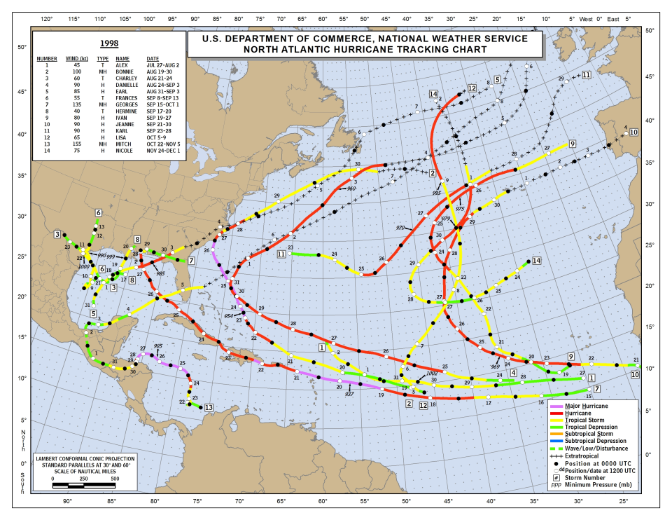
The 1998 hurricane season had the average number of storms — 14 — but of those, 10 were hurricanes, and three were major hurricanes.
"It will be remembered as the most deadly hurricane season in over 200 years. One of the most powerful hurricanes on record, Hurricane Mitch, is blamed for an estimated 11,000 deaths in Central America," according to NOAA's National Centers for Environmental Information.
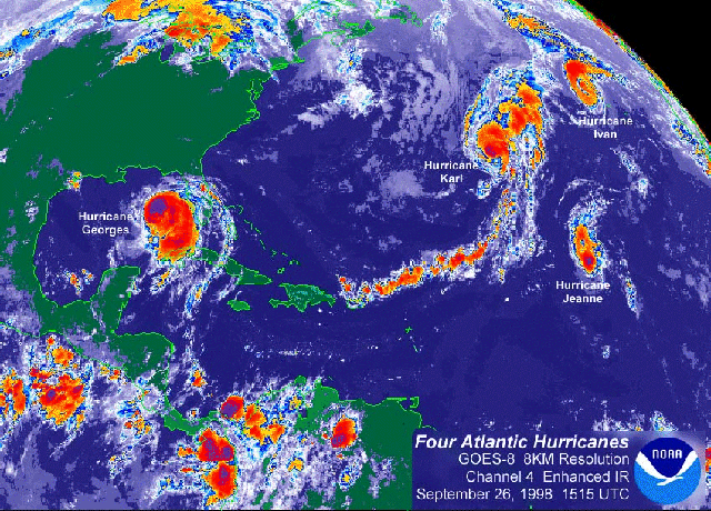
The year was also memorable for another reason: There were four simultaneously occurring hurricanes in the Atlantic" in September.
Soon after La Niña conditions formed during the late spring and early summer, "the Atlantic basin witnessed the formation of 10 named storms within 36 days from Aug. 19 through Sept. 23," according to NOAA's National Centers for Environmental Information.
The season got off to a slow start, with Tropical Storm Alex becoming the first named storm of the season when it formed July 27.
The season ended with Hurricane Nicole, a "tenacious tropical cyclone" that formed on Nov. 24 and didn't dissipate until Dec. 1, according to the National Hurricane Center.
Tropical Storm Alex, July 27-Aug. 2.
Maximum sustained winds: 51 mph
Major Hurricane Bonnie, Aug. 19-30
Maximum sustained winds: 115mph
Tropical Storm Charley, Aug. 21-24
Maximum sustained winds: 69 mph
Hurricane Danielle, Aug. 24-Sept. 3
Maximum sustained winds: 103 mph
Hurricane Earl, Aug. 31-Sept. 3
Maximum sustained winds: 97 mph
Earl made landfall on the Florida Panhandle as a Category 1 hurricane, bringing significant storm surge flooding in the Big Bend area of Florida.
Tropical Storm Frances, Sept. 8-Sept. 13
Maximum sustained winds: 63 mph
Major Hurricane Georges, Sept. 15-Oct. 1
Maximum sustained winds: 155 mph
Georges made landfall on Key West, Florida with maximum winds of 103 mph.
Tropical Storm Hermine, Sept.17-20
Maximum sustained winds: 46 mph
Hurricane Ivan, Sept. 19-27
Maximum sustained winds: 92 mph
Hurricane Jeanne, Sept. 21-30
Maximum sustained winds: 103 mph
Hurricane Karl, Sept. 23-28
Maximum sustained winds: 103 mph
Hurricane Lisa, Oct. 5-9
Maximum sustained winds: 74 mph
Major Hurricane Mitch, Oct. 22-Nov. 5
Maximum sustained winds: 178 mph
Hurricane Nicole, Nov. 24-Dec. 1
Maximum sustained winds: 86 mph
1926: 'Great Miami Hurricane of 1926' destroyed Southwest Florida
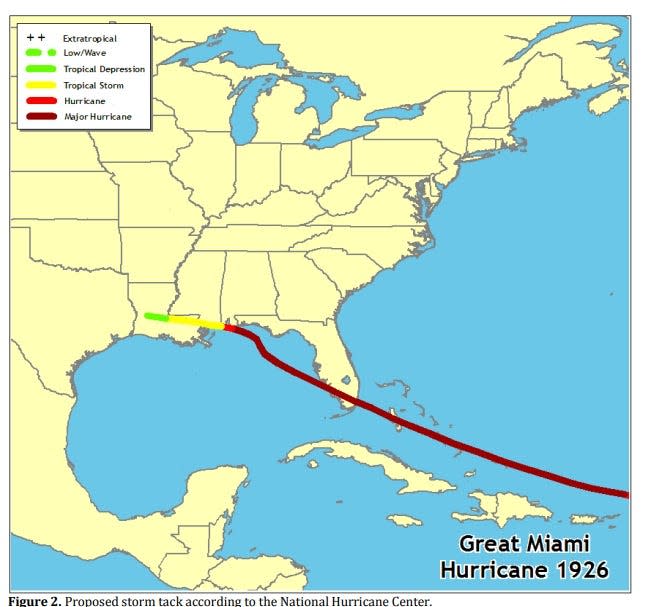
In 1926, there were 25 tropical cyclones: 12 hurricanes, six of which would be considered major hurricanes; and 13 tropical storms, according to NOAA. This was the highest number of storms in a season reported at that time. Storms in those days were not named, although one would later become known as the Great Miami Hurricane of 1926.
The hurricane "destroyed Southwest Florida," according to the National Weather Service.
The storm made landfall at 6:10 am in Miami as a Category 4 hurricane. A storm surge of nearly 15 feet was reported in Coconut Grove. At the height of the storm surge, the water from the Atlantic extended all the way across Miami Beach and Biscayne Bay into the City of Miami for several city blocks.
Every building in the downtown district of Miami was damaged or destroyed, according to the National Weather Service.
➤ Interactive map of 1926 hurricane
The storm flooded the entire island of Sanibel with salt water and forced almost half of the island's residents to relocate.
The town of Moore Haven on the south side of Lake Okeechobee was flooded by lake surge from the hurricane. Hundreds of people in Moore Haven were killed by the surge.
Officials estimated the storm destroyed 4,700 homes in South Florida and left 25,000 people without shelter. The Red Cross reported 373 people lost their lives and more than 6,000 people were injured in the storm, according to NWS. Many people headed into the streets during the eye of the storm.
After entering the Gulf of Mexico, the storm nearly stalled south of Pensacola, hitting the central Gulf Coast with 24 hours of heavy rainfall, hurricane-force winds, and storm surge. Nearly every pier, warehouse, and vessel on Pensacola Bay was destroyed, according to NWS.
The hurricane made a second landfall near Pensacola, where the peak wind was 116 mph and there was a high tide of 9.4 feet.
The storm is said to have brought about the end of the Florida building boom of the 1920s.
Quick facts from NWS:
Minimum pressure: 934.98 mb
Highest storm surge:
14 feet in Miami
6 feet in Fort Myers
Landfall pressure: 934.98 mb
Death toll: about 373
Peak winds:
150 mph in Miami
100 mph in Punta Rassa
1878: 'Gale of '78' killed 71, washed cattle out to sea
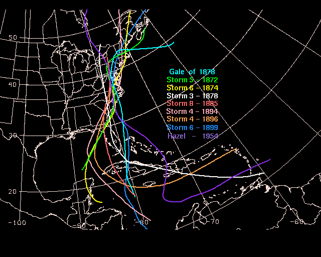
In 1878, there were 12 tropical cyclones reported, including two that would be considered major hurricanes today. Of the 12, 10 were hurricanes and two were tropical storms, according to NOAA.
"Storm 9" of the 1878 season developed in the western Caribbean. "Once its presence was known, the U.S. Signal Corps, a division of the War Department, tracked its progress northward just off the Florida coast into North Carolina and issued signals to warn of its arrival," according to NOAA.
"It is believed that hurricane-force winds lashed the Gold Coast of Florida due to the high winds seen at Key West," NOAA reported.
Along the coast, the Virginia barrier islands of Smith and Cobb went underwater for the first time in memory, taking all cattle out to sea.
In Florida, winds peaked at 54 mph and rainfall was 4.83 inches. Over a dozen vessels were driven aground between the Florida Straits and Cape Canaveral.
Seventy-one people died in the eastern United States due to the Gale of '78.
The storm showed some similarities to later storms, including Agnes in 1972 and Hazel in 1954.
When does hurricane season begin?
The Atlantic hurricane season runs from June 1 through Nov. 30.
Storms can and do form before and after those dates, though.
Both La Niña and El Niño tend to reach peak intensity from fall through winter, according to AccuWeather.
The busiest portion of the Atlantic hurricane season occurs from August through October, with the peak being Sept. 10.
This article originally appeared on Treasure Coast Newspapers: 2024 hurricane season compared to 5 similar years: Lessons to learn

