Six Months With onX Backcountry
onX is a name you all may well be familiar with by this point. The digital mapping app came from humble beginnings as a Missoula hunter's project to digitize land ownership maps to make it possible for people to know the ownership status of the land they are standing on in real-time. It turns out, people like the ability to know if they're trespassing or not when they're navigating in the backcountry.
Anyway, flash forward 15 years and the app has expanded well beyond hunting into climbing, backcountry skiing, and mountain biking which is what brings us here today. I have spent the last six months or so with the onX Backcounty app specifically using the mountain bike mode.
For Some Background
onX acquired all of the Mountain Project data which included mountain bike project, a contributor-based trail map and information database, and introduced it to their already robust platform which is one of the biggest selling points of onX.
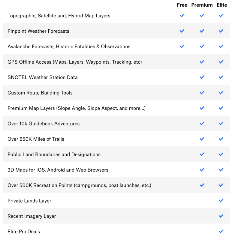
Also, onX Backcountry comes in three tiers, a free version, a mid tier premium version for $30/year and an elite version for $100/year.
onX Backcountry
Let's Talk Features
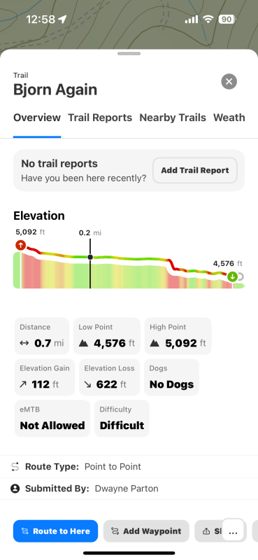
Okay, so let's get into the MTB mode specifically. First, the trail data itself is very good for the existing trails. It provides a ton of information on the trail you select from the elevation profile to recent reports, accessibility, high and low points, elevation gain and loss, and nearby trails. Where it really begins to diverge from other MTB trail map apps is that on the same screen, it also has a tab for weather that is pinpointed for the area that the trail you have selected is in.
onX Backcountry
The weather feature isn't just a brief blip either, it has hourly forecast, precip, long-range forecast, barometric pressure, and basically anything you would need to plan a ride today or a week from now.
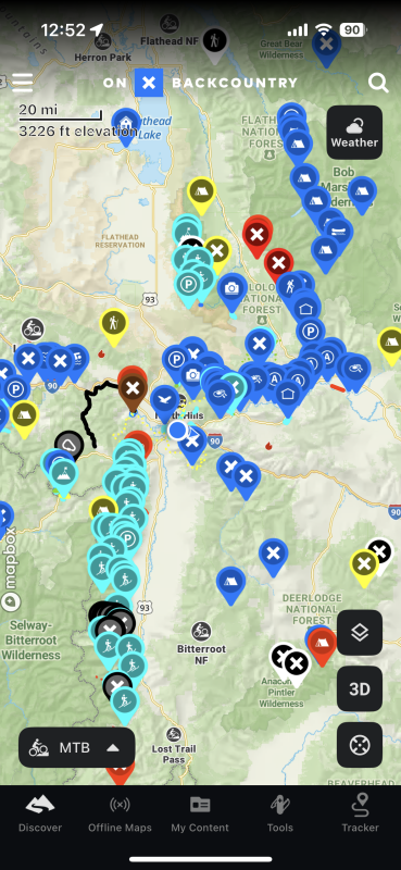
Where it begins to rise above other MTB map apps for me comes back to the robustness of the infrastructure of onX that I mentioned above and features like route making and tracking that allow you to essentially build your own private little database of trails that you can choose to share privately with others or upload to the greater public map. This feature is fantastic for making maps of those trails that may not appear on conventional public trail maps.
onX Backcountry
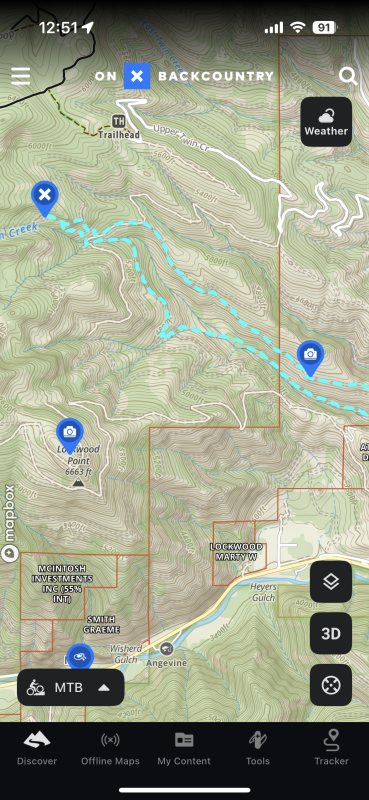
Mapping your rogue trail network aside, the route building feature for gravel and road riding is very useful as well. onX has a very expansive road layer that encompasses forest service and fire roads and if you really want to get into the weeds, get the Offroad app as well to plan true backcountry bikepacking excursions.
The Meat Of It
The thing that makes onX very valuable to route planning distance mountain bikers is that the app is built around a very highly detailed and interactive map that throws so much information at you that it essentially becomes a one-stop shop for all of your route making needs.
The features that circle back to any sort of mountain bike adventure planning that I found myself reaching for the most were the integrated navigation to the trails I wanted to ride, the embedded layer of campsites and amenities which proved very helpful, and the tracking. The tracking and personal database was a major selling point for me.
onX Backcountry
Above all else the feature that is exceptionally fun to poke around with and use to gain a better understanding of the area around you is the land ownership mapping. Whether you're just interested in who owns what or trying to figure out if it is actually okay for you to bike on a secret trail, it's a very nice layer to have.
Another very convenient layer for us out West, especially in the summer, is the fire mapping. Knowing where forest fires are is a huge help for planning where you can go ride and what the smoke will be like in the heart of fire season.
The major drawback I ran into is simply the lack of trails on the app. Compared to other more widely utilized publicly sourced mapping apps, onX has a fraction of the trails. I think that will improve with time and more users get on the app and adding data, but as it stands, there is a major gap between the amount of trails and zones on onX and other apps.
My Takeaways
My overarching takeaway from onX Backcountry is that the value of the app is far greater than just its trail network. The incredibly utilitarian yet beautiful basemap provides a much more familiar experience to those who grew up looking at USGS topos and for those with GIS familiarity, it integrates a lot of the tools you would see in GIS programs but on a much more accessible level.
All in all, onX Backcountry MTB is an incredibly powerful app for mountain bikers that makes up for its less robust trail networks with a wealth of other relevant and quite convenient features. I haven't found a better one stop shop of an app for planning a day out or a trip on the mountain bike. It gives you more tools than you can feasibly use to be as prepared as possible when going out for a ride.
Related: OnX Backcountry Launches New 'MTB Mode' With 150k+ Miles Of Trails

