Nashville travel 'treacherous' after snow impacts conditions; winter storm warning in effect
Editor's note: We've made this winter storm updates file free and available to all readers as our coverage continues. Please consider becoming a subscriber to enjoy more of our work. Thank you.
Looking for Friday weather updates? Go here.
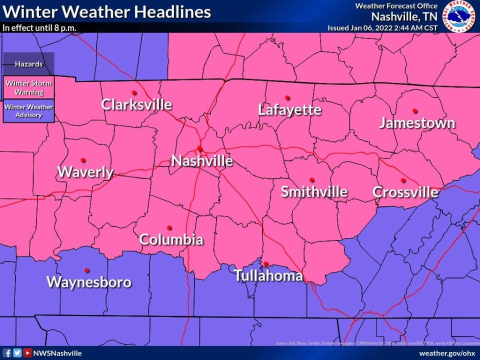
A winter storm warning is in effect for most of Middle Tennessee as snow moves through the region Thursday.
"Snow will spread from west to east across the mid state during the morning, and will end during the late afternoon and evening," NWS Nashville said in a tweet. "Significant travel impacts are anticipated."
FRIDAY WEATHER UPDATES: 'Frigid' temperatures Friday after up to 9 inches of snow fell Thursday
The first reports of snow and sleet came in around 7 a.m. in the western part of the region as the sun rose. Snow was first seen in Nashville around 7:30 a.m. before overtaking the rest of the region.
By Thursday afternoon, NWS reported snow totals as high as 7 inches in parts of Middle Tennessee.
Anywhere from 4-7 inches of snow has fallen in Nashville, Clarksville, Smithville, Crossville and Waverly as of Thursday afternoon . Around 1-4 inches fell in Columbia and Waynesboro. While Tullahoma saw a wintry mix with little to no snow.
Most of the region is under a winter storm warning until 8 p.m.
So far a wide band of 4 to 7 inch snow has fallen,
Lesser amounts farther south, especially near the Alabama border where sleet and freezing rain has been more common. Tapering off soon, but hazardous travel will continue. Very cold night, so have extra gear if you must travel. pic.twitter.com/qm6CwKcicH— NWS Nashville (@NWSNashville) January 6, 2022
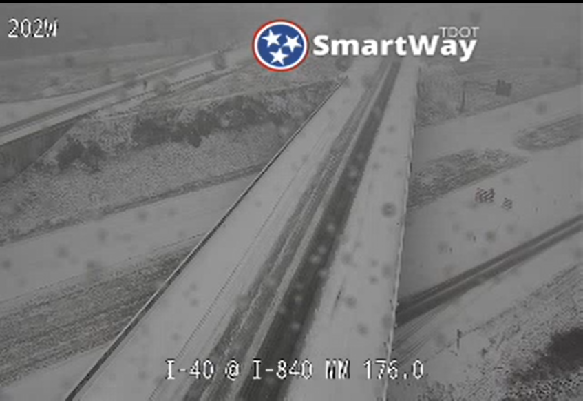
Road conditions quickly deteriorated on Thursday through the morning commute, with multiple wrecks peppering the region and slick roadways causing back-ups. In Nashville, a fire truck and city bus collided, hurting two firefighters, two bus passengers and the bus driver, officials said. All five were taken to area hospitals, and at least three had non-critical injuries, NFD spokesperson Kendra Loney said.
Dangerous road conditions will continue Thursday and could linger into Friday, officials warned. If you must travel, slow down and give yourself extra time. NWS recommends keeping an extra flashlight, food and water in your vehicle in case of an emergency. Keep in mind that elevated surfaces, like bridges, may ice before roads. Call 511 to get the latest road conditions.
Be prepared: 5 tips to get your home ready for winter weather
A blast of frigid temperatures will follow the snow overnight Thursday and into Friday morning, dipping to single digits in some areas. Temperatures aren't expected to go above freezing until Saturday.
Middle Tennessee got its first snow of the year overnight Sunday and into Monday morning. The region saw anywhere between a half-inch up to 9 inches of snow. The snow and ice caused a few school delays and cancellations across the region.
Snow prompts school, other closures
The expected snow prompted school closures across the region Thursday. Find a file with the latest major public school closures here. Metro Nashville Public Schools announced it would be closed Friday, along with several others.
SCHOOL CLOSINGS IN MIDDLE TN: Districts cancel classes ahead of expected snow
Middle Tennessee State University also announced it was closed Thursday. Schools like Vanderbilt University, Tennessee State University and Belmont University had already delayed the start of classes or moved to virtual due to COVID-19.
Tennessee officials also announced that all state offices will be closed statewide. Employees who can work from home will continue to work, and state services offered online will still be available.
Nashville said many of its facilities and buildings will be closed Thursday, including health clinics and facilities, libraries and others. The city's drive-thru COVID-19 testing and vaccination sites are closed Thursday due to the weather. The latest updates on COVID-19 and testing sites can be found at asafenashville.org.
Government offices for Wilson County, Lebanon and Mt. Juliet are closed Thursday. Wilson County Health Department vaccination and testing are closed Thursday.
Murfreesboro announced the closure of city hall and city facilities for Thursday and Friday. City court dates and meetings are canceled, Murfreesboro Transit will not be operating and solid waste collection will be limited.
Road conditions, where to find Nashville traffic cameras
The Tennessee Department of Transportation began pre-treating roads on Wednesday ahead of the anticipated snow and ice. Salt and supplies were also stocked up ahead of the winter season.
“We prepare for winter weather months in advance,” TDOT Commissioner Joe Galbato said in a news release. “Clearing our roadways as soon as we can is vital to keeping motorists safe and traffic moving in Tennessee.”
When snow and ice hit, TDOT focuses on interstates and heavily traveled state routes, along with areas prone to freezing like hills, curves, ramps, bridges and interchanges.
Find winter weather tips, travel information and more at tn.gov/tdot/inclement-weather. You can also follow @myTDOT on Facebook and Twitter for urgent traffic information. Call 511 for the road conditions in your areas.
You can also use the Tennessee Department of Transportation's SmartWay map to view real time traffic conditions by clicking on "traffic cameras" from the drop down feature menu at the top right.
Nashville police responded to dozens of crashes around the city throughout the morning. At one point, I-40 westbound was closed by a multi-vehicle wreck at the I-65 interchange. Multiple other wrecks slowed traffic on interstates and roads through the city.
"Travel throughout Nashville is treacherous," the Metro Nashville Police Department warned.
Travel throughout Nashville is treacherous. A semi-truck crash is blocking I-24 east near Hickory Hollow. The slick Harding Place exit on I -65 south has multiple vehicles unable to move. Murfreesboro Pike outbound in the Fesslers Lane area is significantly backed up. pic.twitter.com/1qq5IanoBU
— Metro Nashville PD (@MNPDNashville) January 6, 2022
Mt. Juliet Police also reported hazardous road conditions and multiple wrecks Thursday morning, warning that some roads are not passable, especially those with hills or grades. Police said multiple motorists were stranded on Old Lebanon Dirt Road near Moreland Hills Drive around 11 a.m., with officers on the scene. That roadway is among several in Mt. Juliet that are closed, according to police.
Wilson County Emergency Management Agency Director Joey Cooper reported multiple wrecks. Officials in Lebanon also said they were responded to multiple crashes.
Nashville opens extreme cold weather shelter
Nashville opened its extreme cold weather shelter on Wednesday night ahead of the storms. It will remain open until 9 a.m. Saturday. The Office of Emergency Management will also send out "cold patrols" to make sure people in need of shelter find it, and distribute things like blankets, gloves, hand warmers and other care items.
The overnight shelter is open to anyone who needs it at 3230 Brick Church Pike. Men, women, couples and pets are welcome. Overflow shelter activates when temperatures drop to 28 degrees or below in Nashville.
Free transit is available via WeGo Central on WeGo Public Transit line 23B from 7 p.m. to 11 p.m. on nights the extreme cold shelter is open.
The overflow shelter will start taking guests when primary community partner shelters reach maximum capacity, including the Nashville Rescue Mission. Standard operating hours are between 7 p.m. and 7 a.m.
A transportation plan is in place for outreach workers to drop off individuals across the city. Partners will receive directions on how to drop people off at the overflow shelters after hours and seasonal cold weather-activated passes to hand out.
Outreach workers and persons experiencing homelessness can also text "NashvilleWinter" to 84483 to sign up to receive text notifications about 24 hours in advance of each overflow shelter opening.
More information can be found at coldweathernashville.com or by calling 615-862-6391. Updated information on the shelter's hours will be available by 9 a.m. each day.
Snow follows warm, stormy December
The cold snap follows an unseasonably warm December, which was the second-warmest December on record for Middle Tennessee, NWS said. In Nashville, the average temperature was 53.4 degrees, which was 10.7 degrees above normal.
On Christmas Day, Clarksville reached a record-high 75 degrees, breaking the previous record of 74 degrees set in 2016. Nashville reached 78 degrees, breaking its record high set in 2016.
Middle Tennessee also had record number of December tornadoes. Here's a look at the 2021 numbers:
A total of 21 tornadoes broke out across Middle Tennessee in December — five on Dec. 6 and 16 on Dec. 10-11, NWS said. It shattered the record for December tornadoes since record-keeping began.
The Dec. 10-11 outbreak included three EF-2s in Dickson (Dickson County), Kingston Springs (Cheatham County) and Stewart County, with winds between 125 mph and 135 mph.
The December outbreak marked the fifth-largest tornado outbreak on record for Middle Tennessee.
Stewart, Humphreys, Cheatham, Wilson, Trousdale, Overton, Pickett, Coffee and Grundy counties recorded their first-ever December tornadoes.
Middle Tennessee saw a record-breaking 45 tornadoes this year, beating the previous record of 38 set in 2011.
Nashville forecast
Thursday: 100% chance of snow mainly before 4 p.m. High: 30; Low: 9
Friday: Mostly sunny: High: 29; Low: 17
Saturday: Mostly sunny during the day, then showers and a possible thunderstorm overnight. Chance of precipitation is 100%. High: 48; Low: 41
Nashville-area weather radar
Reporter Natalie Alund contributed to this story.
Find reporter Rachel Wegner at rawegner@tennessean.com or on Twitter @rachelannwegner.
This article originally appeared on Nashville Tennessean: Nashville winter weather: Snow impacting traffic, road conditions

