Winds to howl, snow to fly and fire risk to surge over Rockies, High Plains through Sunday


Not only will a strengthening storm kick up winds and stir up some snow for the Rockies and High Plains through the remainder of the weekend, but there will also be difficult travel and a significant amount of power outages with the potential for property damage, wildfires and other dangerous conditions, AccuWeather meteorologists warn.
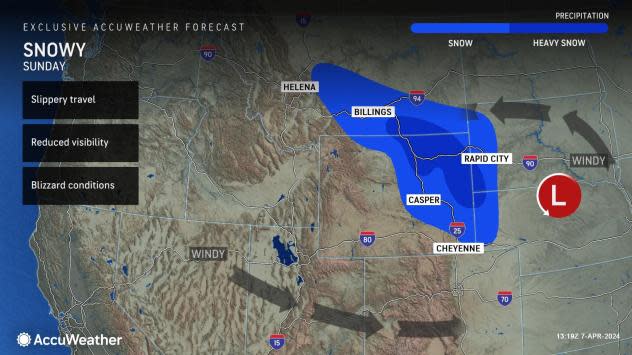
The cold storm began to cross the Intermountain West at midweek with pockets of steady snow over the mountains and snow showers over the valleys. However, the storm lost its fragmented nature and strengthened quickly into Saturday night as it redeveloped over the Nebraska Panhandle.
Several inches of snow will fall and accumulate on roads, creating slippery travel through Sunday. Portions of Interstates 70 in Colorado, 25 and 80 in Wyoming and 15 and 90 in Montana will be most affected.
 |
Snow is one factor with most motorists well accustomed to wintry conditions by the early spring. However, winds will be the most significant aspect of this storm.
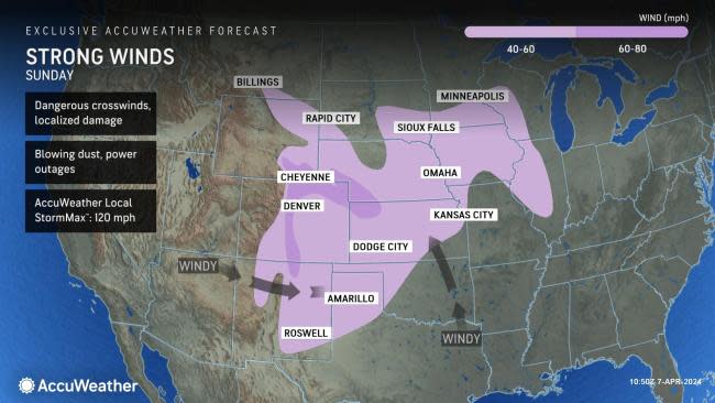
"Powerful winds are expected to sweep down from the ridges and peaks of the central and southern Rockies and onto the adjacent High Plains as the storm strengthens this weekend," AccuWeather Meteorologist Brandon Buckingham said.
The intense winds will impact areas from eastern Wyoming, southern Nebraska and areas of the Midwest to Colorado, Kansas, Oklahoma, New Mexico and the Texas Panhandle.
"Wind gusts from the west of 60-80 miles per hour are possible in places like Boulder, Colorado, over the weekend, which can easily knock out power," Buckingham explained, adding, "In a storm like this, it is not uncommon for sections of Interstate 25 to close because of the strong cross winds and the risk of rollovers they pose for high-profile vehicles." The same concerns will exist along north-south U.S. Routes 83, 287 and 385.
As of Sunday afternoon, roughly 315,000 customers were facing power outages across Colorado alone, according to PowerOutage.US. On Saturday, peak wind gust reports from Nebraska ranged to 76 mph, accompanied by damage to trees and structures.
 |
The AccuWeather Local StormMax™ wind gust for this storm is 120 mph. At speeds of 60-110 mph, not only are power outages likely due to falling trees and downed power lines, but significant property damage can occur. Unsecured objects can become projectiles that can injure people or cause damage.
High winds may negatively affect routine flights in the region with the likelihood of delays and cancellations. Operations at Denver International Airport will be most directly affected, with ripple effects possible throughout the nation.
"The powerful wind gusts will also likely pick up plumes of dust and carry it hundreds of miles, leading to decreased air quality and lowered visibility at times this weekend across portions of the Plains," Buckingham said.
Wildfire risk is another significant factor to be aware of during the storm. Local officials may ban the use of open flames, such as campfires and outdoor barbeque grills.
 |
Although the storm will feature areas of rain and snow for some along the High Plains, Buckingham warned that there is a significant risk of wildfire ignition and rapid spread.
Because winds will get strong enough to bring down power lines and cause sparks, any such incident may trigger a rapidly spreading fire.
The same storm will trigger thunderstorms farther to the east over the Great Plains and Mississippi Valley on Sunday.
Want next-level safety, ad-free? Unlock advanced, hyperlocal severe weather alerts when you subscribe to Premium+ on the AccuWeather app. AccuWeather Alerts™ are prompted by our expert meteorologists who monitor and analyze dangerous weather risks 24/7 to keep you and your family safer.
