Why a helicopter will be flying low in northwest Kansas
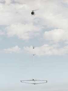
WICHITA, Kan. (KSNW) — Over the next several weeks, residents of northwest Kansas may see a helicopter flying low and dangling a large hexagonal frame even lower. The flights are part of a project to electromagnetically map groundwater conditions in the Ogallala aquifer.
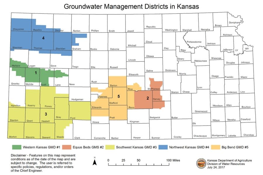
Starting in late May and continuing for much of June, the helicopter will fly over Northwest Kansas Groundwater Management District No. 4, the area in blue on the map.
The hexagonal frame hanging about 100 feet below the helicopter includes scientific equipment for an electromagnetic survey. The frame will be about 100 to 200 feet above the ground.
The equipment in the frame maps geologic structures and groundwater resources hidden as far as 1,000 feet below the land’s surface.
Court documents say bodies of murdered Kansas women found in freezer
“Airborne geophysics doesn’t make water,” Jared Abraham, Aqua Geo Frameworks LLC. “What we’re trying to do is map where it is and where it is not.”
The pilots are specially trained for low-level flying. They’ll be going about 50 mph. They will not go over residential areas, other buildings, livestock feeding operations or wind turbines.
Kansas Groundwater Management District No. 4 and the Kansas Geological Survey, working with Aqua Geo Frameworks, have planned the flights to develop a better understanding of the Ogallala aquifer. The funding comes from the Governor’s Office and the Kansas Water Office.
Aqua Geo Frameworks has done similar electromagnetic surveys in Nebraska, Colorado and Wyoming. This will be the first time it’s done in Kansas. Click here to see a video about the process.
Kansas families can get into 220 attractions for free this summer
The Ogallala aquifer is the primary water resource in northwest Kansas. Over the last 60 years, intensive pumping from the aquifer has resulted in large groundwater level declines in Sherman, Thomas, Sheridan and Cheyenne counties.
The information from the electromagnetic survey could help the Kansas Geological Survey and Groundwater Management District No. 4 better assess the nature and continuity of water-yielding materials in the aquifer and ultimately develop strategies to help sustain it.
The Groundwater Management District 4 website includes a copy of a letter sent to landowners that could be in the flight path. The website will post a flight path map closer to the project.
“Stay tuned to our website, Facebook, and X for information on date, time, and location to bring the family and check out the helicopter, equipment, talk with scientists, and learn more about this exciting process,” the letter says.
The Kansas Geological Survey is a nonregulatory research and service division of the University of Kansas.
Copyright 2024 Nexstar Media, Inc. All rights reserved. This material may not be published, broadcast, rewritten, or redistributed.
For the latest news, weather, sports, and streaming video, head to KSN-TV.


