Weather Blog: Multiple days of severe weather possible


FAYETTEVILLE, Ark. (KNWA/KFTA) — Severe weather, some of which could be significant, is possible over multiple days across Northwest Arkansas and the River Valley. All modes of severe weather, including large hail, damaging winds and tornadoes will be possible throughout the week. Significant flash flooding will also be a concern, especially if thunderstorms “train” over the same areas.
Tuesday

The latest Day 1 Convective Outlook features a Slight Risk (Level 2 out of 5) of severe weather for the vast majority of the KNWA/FOX24 coverage area, with an Enhanced Risk (Level 3 out of 5) located over SW Missouri in Barry and McDonald counties. All modes of severe weather will be possible, including very large hail over 2″ in diameter (hen egg size), damaging winds up to 70 MPH and a couple of tornadoes. Isolated to scattered supercells may develop as early as 5 P.M. in portions of southwestern Missouri, with hail being the initial threat. As low level shear and instability increases throughout the evening, thunderstorms will become more widespread, and eventually spread into Northwest Arkansas from 6 P.M. – Midnight. All severe hazards including tornadoes will be possible by this time, especially if storms can remain semi-discrete as they move off to the southeast. Storms will weaken a bit as they move into the River Valley, however the threat for all modes of severe weather will be possible through 2 A.M. across our weather coverage area.


Wednesday

Many severe thunderstorms, some of which may be significant, will once again be possible throughout the day Wednesday. As of Tuesday morning, most of the coverage area is under an Enhanced Risk (Level 3 out of 5) of severe weather, mainly along and south of the Bobby Hopper Tunnel. The rest of far Northwest Arkansas, SW Missouri and NE Oklahoma is under a Slight Risk (Level 2 out of 5) of severe weather, which includes portions of Benton and Washington County. All modes of severe weather will be possible with any storms that develop, as a front becomes stationary across much of the Boston Mountains. Initially, an intense line of thunderstorms will develop early Wednesday morning to our west, and this line will bring the potential for damaging wind gusts over 75 MPH and embedded tornadoes. Significant rainfall totals will also be possible, especially along and south of the I-40 corridor. Once this line moves through, additional thunderstorms may develop along the front throughout the afternoon and evening hours, though uncertainty remains in terms of how much instability will be left over after the morning line of storms. Regardless, very heavy rainfall will once again be possible, and significant flash flooding will become an increasing concern if thunderstorms can develop and move over the same areas.

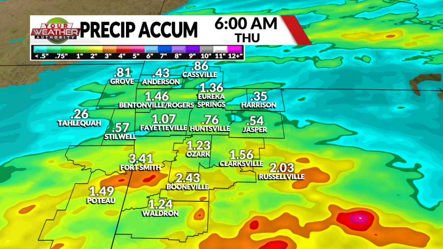
Thursday

Thursday features another chance for severe weather, as the entire weather coverage area is under a Slight Risk (Level 2 out of 5) in the latest Day 3 Convective Outlook. All modes of severe weather will be possible, as the boundary lifts back to the north as a warm front. However, there is still uncertainty in terms of the timing and overall coverage of storms. Stay tuned to the latest details as more high-resolution data becomes available.
Friday – Sunday


More heavy rainfall and severe weather potential will be possible Friday – Sunday across Northwest Arkansas and the River Valley. Multiple rounds of showers and storms appear possible each day, though Saturday night into Sunday morning looks to be the most likely time frame for severe weather over our weather coverage area. Specific details still need to be ironed out in terms of the timing and strength of the storm system, but all modes of severe weather and scattered to widespread flash flooding will once again be possible. Stay tuned to this live weather blog as this risk will be adjusted significantly over the coming days.
Prepare For Severe Weather


Follow YOUR Weather Authority Team:
On Twitter
On Facebook
STAY INFORMED
Click Here to Download our Weather Authority app
To make sure you are staying up-to-date with the forecast, download the Your Weather Authority app to get updates anywhere at any time.
Copyright 2024 Nexstar Media, Inc. All rights reserved. This material may not be published, broadcast, rewritten, or redistributed.
For the latest news, weather, sports, and streaming video, head to KNWA FOX24.

