Tornadoes. Hail. Near record-high temps. Cold front. That's Florida's forecast this week
Yet another cold front is expected to move into Florida today, bringing severe weather to northern Florida and thunderstorms farther south.
In the meantime, Central Florida could experience near-record-high temperatures are possible across south Central Florida.
Severe storms are possible in northern Florida Wednesday into Thursday as the front moves down the state. Some of the storms could bring wind gusts up to 80 mph, strong tornadoes and quarter-sized hail, according to the National Weather Service Mobile.
Some of the tornadoes could be EF-2 or higher, NWS forecasters said. An EF-2 tornado has wind speeds of 111 to 135 mph. The threat for tornadoes will ramp up Wednesday and Wednesday night, particularly along the Gulf Coast, according to AccuWeather.
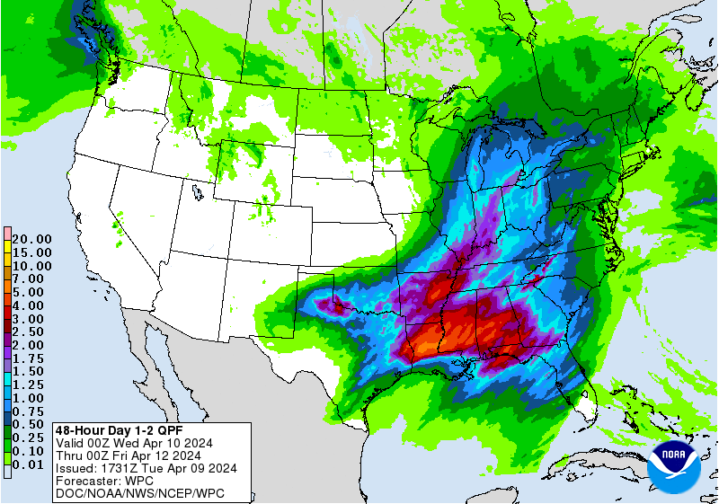
The storms are part of a weather system moving east from the south central U.S.
The system is expected to reach Central Florida, including Polk County, early Thursday afternoon and last well into the evening, albeit the warnings aren't quite as dire for our region. Before it comes through, however, temperatures are expected to reach near 90 degrees.
Here's a look at the forecast for the area around Polk County.
Live weather radar: Check out the live weather radar for the U.S., Southeast and locally
Lakeland forecast
Today: Mostly sunny, with a high near 89. South southeast wind 9 to 13 mph.
Tonight: Partly cloudy, with a low around 70. South southeast wind 9 to 13 mph.
Thursday: A slight chance of showers and thunderstorms, then showers likely and possibly a thunderstorm after 2pm. Increasing clouds, with a high near 88. Windy, with a south southwest wind 16 to 25 mph, with gusts as high as 34 mph. Chance of precipitation is 60%. New rainfall amounts between a quarter and half of an inch possible.
Thursday Night: Showers likely and possibly a thunderstorm before 8pm, then a slight chance of showers and thunderstorms between 8pm and 11pm. Mostly cloudy, then gradually becoming mostly clear, with a low around 62. West southwest wind 8 to 14 mph, with gusts as high as 20 mph. Chance of precipitation is 60%.
Friday: Sunny, with a high near 81. Northwest wind 6 to 10 mph.
Friday Night: Clear, with a low around 56. West northwest wind 7 to 10 mph.
Winter Haven forecast
Today: Mostly sunny, with a high near 88. South southeast wind 9 to 14 mph, with gusts as high as 18 mph.
Tonight: Partly cloudy, with a low around 70. Breezy, with a south southeast wind 11 to 15 mph, with gusts as high as 20 mph.
Thursday: A slight chance of showers and thunderstorms, then showers likely and possibly a thunderstorm after 2pm. Increasing clouds, with a high near 88. Windy, with a south southwest wind 18 to 24 mph, with gusts as high as 32 mph. Chance of precipitation is 60%. New rainfall amounts between a tenth and quarter of an inch, except higher amounts possible in thunderstorms.
Thursday Night: Showers and thunderstorms likely, mainly before 11pm. Mostly cloudy, then gradually becoming mostly clear, with a low around 62. Breezy, with a west wind 9 to 16 mph, with gusts as high as 22 mph. Chance of precipitation is 60%.
Friday: Sunny, with a high near 82. Northwest wind 7 to 10 mph.
Friday Night: Clear, with a low around 56. West northwest wind 8 to 10 mph.
https://radar.weather.gov/ridge/standard/KTBW_loop.gif
Bartow forecast
Today: Mostly sunny, with a high near 89. South southeast wind 9 to 14 mph, with gusts as high as 18 mph.
Tonight: Partly cloudy, with a low around 70. South southeast wind 8 to 13 mph.
Thursday: A slight chance of showers and thunderstorms, then showers likely and possibly a thunderstorm after 2pm. Increasing clouds, with a high near 89. Windy, with a south southwest wind 16 to 26 mph, with gusts as high as 36 mph. Chance of precipitation is 60%. New rainfall amounts between a quarter and half of an inch possible.
Thursday Night: Showers and thunderstorms likely, mainly before 11pm. Mostly cloudy, then gradually becoming mostly clear, with a low around 62. Breezy, with a west southwest wind 9 to 16 mph, with gusts as high as 22 mph. Chance of precipitation is 60%.
Friday: Sunny, with a high near 82. Northwest wind 6 to 10 mph.
Friday Night: Clear, with a low around 56. Northwest wind 7 to 10 mph.
Lake Wales forecast
Today: Mostly sunny, with a high near 87. South southeast wind 10 to 14 mph, with gusts as high as 20 mph.
Tonight: Partly cloudy, with a low around 69. South southeast wind 11 to 14 mph, with gusts as high as 18 mph.
Thursday: A chance of showers and thunderstorms between 2pm and 5pm, then showers likely and possibly a thunderstorm after 5pm. Increasing clouds, with a high near 89. Windy, with a south southwest wind 16 to 25 mph, with gusts as high as 34 mph. Chance of precipitation is 60%. New rainfall amounts between a quarter and half of an inch possible.
Thursday Night: Showers and thunderstorms likely, mainly before 11pm. Mostly cloudy, then gradually becoming mostly clear, with a low around 62. Breezy, with a west southwest wind 10 to 17 mph, with gusts as high as 23 mph. Chance of precipitation is 60%.
Friday: Sunny, with a high near 82. Northwest wind 8 to 10 mph.
Friday Night: Clear, with a low around 56. West northwest wind around 10 mph.
Poinciana forecast
Today: Partly sunny, with a high near 87. South southeast wind 5 to 15 mph, with gusts as high as 20 mph.
Tonight: Partly cloudy, with a low around 70. South southeast wind 10 to 15 mph, with gusts as high as 20 mph.
Thursday: A slight chance of showers and thunderstorms, then showers likely and possibly a thunderstorm after 2pm. Partly sunny, with a high near 89. Windy, with a south wind 20 to 25 mph increasing to 25 to 30 mph in the afternoon. Winds could gust as high as 40 mph. Chance of precipitation is 70%. New rainfall amounts between a quarter and half of an inch possible.
Thursday Night: Showers likely and possibly a thunderstorm before 8pm, then a slight chance of showers and thunderstorms between 8pm and 2am. Mostly cloudy, then gradually becoming mostly clear, with a low around 61. Windy, with a west southwest wind 10 to 20 mph, with gusts as high as 25 mph. Chance of precipitation is 60%.
Friday: Sunny, with a high near 81. Northwest wind 5 to 10 mph.
Friday Night: Clear, with a low around 56. West northwest wind around 10 mph.
Ledger staff contributed.
This article originally appeared on The Ledger: Cold front bringing wild weather to Florida, and thunderstorms to Polk

