Severe thunderstorms with hail and damaging wind target Southeast, Plains on Wednesday
ORLANDO, Fla. – Wednesday was another active day for severe weather in three parts of the U.S. with powerful thunderstorms capable of producing damaging wind gusts, large hail and possible tornadoes in areas from the Plains to the East Coast.
A Tornado Watch had been in effect for portions of central and northern Florida earlier on Wednesday morning but was replaced by a Severe Thunderstorm Watch just before 11 a.m. ET.
A Severe Thunderstorm Watch was issued further north Wednesday afternoon and includes about 6.6 million people in parts of South Carolina and North Carolina. The watch includes the cities of Myrtle Beach, Columbia and Florence in South Carolina and Charlotte, Fayetteville and Wilmington in North Carolina. It is in effect until 8 p.m. ET.
Additionally, Severe Thunderstorm Watches have been issued for parts of Texas, Oklahoma and Kansas until after sunset.
MAY IS PEAK MONTH FOR TORNADOES IN THE US
The thunderstorm risk also stretches from Texas to Nebraska. However, portions of northwestern Texas, western and northern Oklahoma and southern Kansas have been placed in a Level 3 out of 5 risk of severe weather on Wednesday.
This includes about 1 million people in cities like Amarillo in Texas, as well as Enid, Stillwater, Ponca City and Yukon in Oklahoma. Communities along Interstate 35 in Kansas south of Wichita are also included.
ADVICE FOR DEALING WITH STORM ANXIETY WHEN SEVERE WEATHER THREATENS
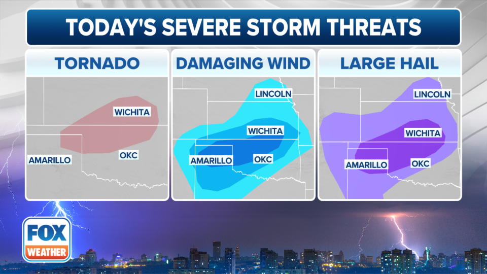
Storms that develop in those areas will not only be capable of producing deadly, cloud-to-ground lightning, but large hail, damaging wind gusts and tornadoes will also be possible.
Original article source: Severe thunderstorms with hail and damaging wind target Southeast, Plains on Wednesday

