New tool tracks ship speeds to protect whales
A new online map is available to help marine vessels avoid collisions with critically endangered North Atlantic right whales in the Gulf of St. Lawrence.
Whale Safe was developed by scientists at the Benioff Ocean Science Lab, a centre for applied marine conservation at the University of California, Santa Barbara.
The lab concentrates on using AI-powered ocean sensors, big data models, citizen science, and ship tracking to prevent ship strikes, which are one of the main causes of serious whale injuries and deaths.
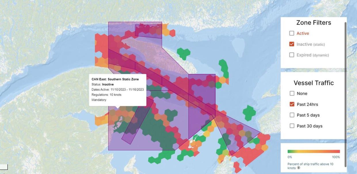
Its Whale Safe tool uses cloud computing to analyze billions of data points from the automatic identification system, or AIS, a transceiver-based tracking system for marine traffic, said Rachel Rhodes, a data scientist at the Benioff lab.
Whale Safe can show in near real time where speed limits are in place and which vessels are complying, she said.
"The cool thing about this tool is that ... it's filtering to only grade these vessels where these zones are in effect and when it's the appropriate vessel size," Rhodes said.

Rachel Rhodes is a data scientist who helped develop the Whale Safe North America mapping and analysis tool for marine vessels. (Benioff Ocean Science Laboratory)
Whale Safe was developed after a rise in ship strikes on the West Coast a few years ago, she said. It launched in that area in 2020.
Based on demand from shipping companies, it has now been expanded to all of the slow speed zones around North America, she said.
The goal is to help in voyage planning and logistics to slow down.
"We recognize there's a lot to keep track of for these ship captains and crews and companies with knowing when these zones are in effect. Some ... are dynamic, so they pop up based on sightings or acoustic detections. … We know no one wants to hit a whale."
The Whale Safe company works with shipping companies to help them identify what vessels in their fleet are the best and worst at respecting whale protection measures, Rhodes said.
Some shipping companies operating on the West Coast have used the information provided to improve their grades from F's to B's, she said.
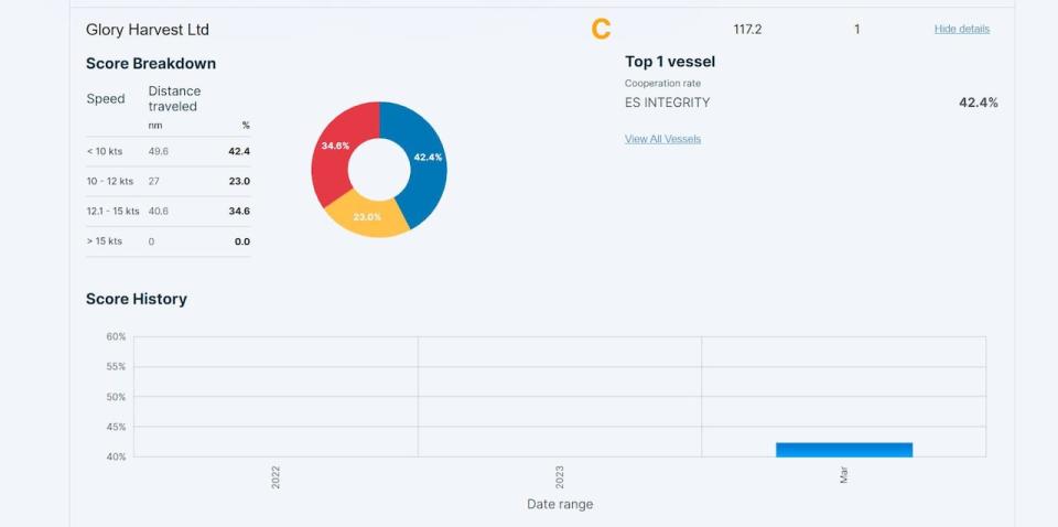
An example of a Whale Safe scorecard for one of the companies whose ship was in the Gulf of St. Lawrence on Thursday. (Whale Safe North America)
Last year, vessels slowed down to speed limits 59 per cent of the time, said Rhodes.
"There's some companies that are getting A's and B's, but there's also a lot of companies that are getting D's and Fs and have a lot of work to do to improve this overall co-operation," she said.
Out of several ships that happened to be in the Gulf of St. Lawrence when publicly available AIS data was sampled on Thursday, only one was in the Whalesafe database.
The ES Integrity was on its way to Gibraltar, according to MarineTraffic.com.
That site doesn't say who owns the vessel, but according to Whale Safe, it belongs to Glory Harvest Ltd.
It's the only vessel belonging to that company currently in the Whale Safe database.
More vessels and companies will show up once they have transited through reduced speed zones, said Rhodes.
Glory Harvest's co-operation rate so far, based on its travels through other zones along the eastern seaboard that are already in effect, is 42.4 per cent, giving it a C grade.
Several other vessels that were in the Gulf on Thursday — the Canadian oil/chemical tanker Algoluna, the bulk carrier Federal Sakura, flying the flag of Marshall Islands, the Dutch general cargo ship Muntgracht, and the oil products tanker Dubai Green — either haven't passed through reduced speed zones yet this year or aren't in S&P Global's Information Handling Services database.
To be included in the Whale Safe tool, vessels also have to be using the AIS system.
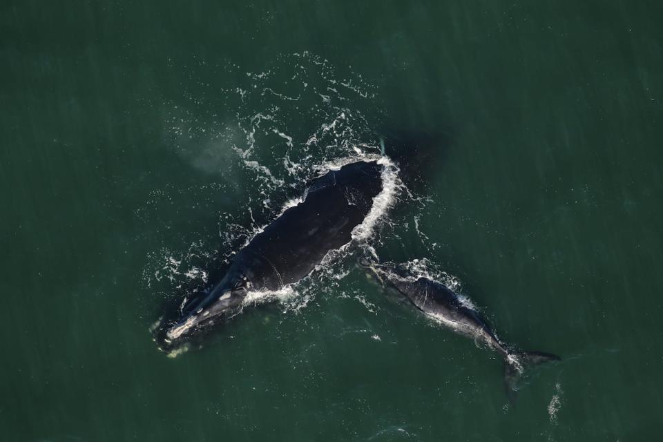
A North Atlantic right whale and her calf off the coast of the southern United States in 2020. (NOAA Fisheries/Twitter)
This year's federal measures to protect whales from vessel strikes are the same as last year's, according to a news release from Fisheries and Oceans Canada.
They include speed restrictions in the Gulf of St. Lawrence. Where whales are detected, all vessels longer than 13 metres must proceed at a speed of not more than 10 knots.
There's also an area in the southern Gulf, where whales have been found to congregate, that's off limits to vessels over 13 metres in length.
Those restrictions are set to take effect April 17 and remain so until Nov. 15.
Fines of up to $250,000 can be issued for violations.
The estimated right whale whale population as of October was 356, according to the North Atlantic Right Whale Consortium.
Five North Atlantic right whales have been found dead so far this year, according to the U.S. National Oceanographic and Atmospheric Administration — at least three from vessel strikes.

