Thunderstorms set to kick off the weekend for parts of the Prairies
The return of warmer temperatures to the Prairies will herald the return of thunderstorms for parts of the region on Saturday.
Several areas on the western and eastern Prairies look favourable for scattered storms to pop up through the day Saturday. They shouldn’t grow severe, but prepare to head indoors if thunder roars nearby.
Additional rain is good news heading into wildfire season, though some dry weather is needed for the planting season across agricultural regions.
DON’T MISS: Canada’s long weekend forecast may switch up your outdoor plans
We’ll kick off the weekend with a low-pressure system near Hudson Bay dragging a cold front south across the Prairies through the day Saturday.
Warm temperatures building ahead of the front will send daytime highs into the middle to upper 20s throughout southern sections of all three provinces.
Toasty readings will provide the instability needed to fuel a risk for scattered thunderstorms on Saturday afternoon. Forecasters are monitoring two regions where storms are possible.
A cold front sliding into Alberta is a recipe for upsloping winds, which may provide enough of a kick needed to spark scattered thunderstorms in the region.
Summertime thunderstorms are notoriously tough to predict exactly where they’ll pop up. But communities along the QE2 from Calgary to Red Deer and west may have to dodge the occasional heavy shower or storm on Saturday afternoon.
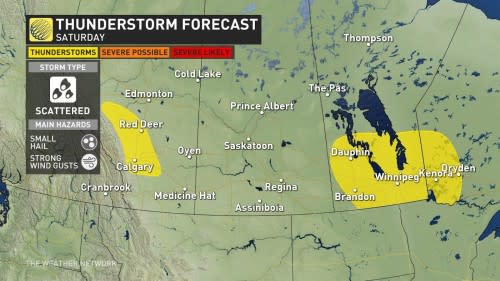
Farther east, scattered thunderstorms are expected to develop along and ahead of the cold front as it chugs into southern Manitoba. This covers just about everyone from Dauphin south, including the Winnipeg metro area. The threat pokes into northwestern Ontario, as well, with a storm or two possible around Kenora and Dryden.
While Saturday’s storms should remain below severe limits, any stronger storms that bubble up could produce small hail and gusty winds.
MUST SEE: What La Niña could mean for Canada’s upcoming summer
We’ll see a risk for more rain building into parts of southern Manitoba through Sunday and Monday.
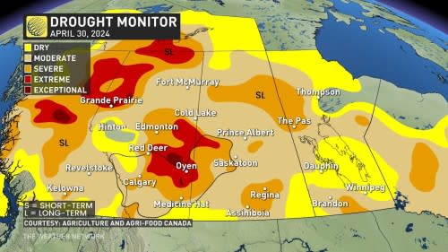
All of this additional rainfall is good news for the region’s long-running drought as we inch closer to the heart of wildfire season. The latest update of the drought monitor continues to show the vast majority of the Prairies mired in a moderate drought or worse as of April 30.
This update doesn’t include the rain we saw during the first week of May, so there’s likely been some further improvement across southern Alberta and southern Saskatchewan.
Severe drought remains widespread throughout the northern Prairies, with some relief possibly in sight by the end of next week.
Stay with The Weather Network for all the latest on your forecast across the Prairies.

