100+ mph winds, stuck vehicles: Dangerous blizzards hit mountains in West
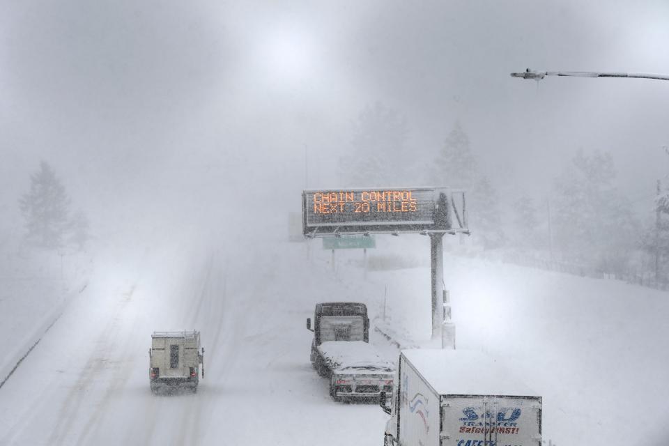
Life-threatening blizzard conditions along the mountain range between California and Nevada this weekend have stranded vehicles on dangerous roads as the storm dumps up to 10 feet of snow in some areas.
The winter weather has closed Yosemite and prompted a National Weather Service office to warn against visiting ski resorts. Snow levels at Lake Tahoe are expected to reach 6 feet, though higher elevation areas could see more. Driving conditions are considered "extremely dangerous to impossible" with low visibility and whiteout conditions, forecasters warned.
North of Lake Tahoe, on I-80, many vehicles were stuck overnight on Donner Summit, California Highway Patrol said. It took several hours for emergency personnel and tow trucks to reach motorists due to blizzard conditions, police say.
As of Saturday, transportation officials were working to recover vehicles left on the freeway, CHP said. There is no estimated time of reopening the highway.
The eastern Sierra Nevada had high danger for avalanches through Sunday evening, the NWS Reno office said.
See photos: California snowstorm brings blizzard conditions to Sierra Nevada, Lake Tahoe
Lake Tahoe ski resorts see sustained 150 mph wind gusts
Several ski resorts along the crest of the Sierra Nevada near the Lake Tahoe Basin saw wind gusts between 125 and 150 mph for several hours, Scott McGuire, a meteorologist at the NWS Reno office, told USA TODAY.
In a blog post Saturday morning, Palisades Tahoe, which recorded extreme wind gusts, said it closed all chairlifts Saturday due to the wind, visibility and snowfall. Many other resorts closed over the weekend due to the blizzard.
"It’s going to take several days to start getting things back open," McGuire said, "and we’re not done yet."
High winds affect multiple states
Las Vegas, located hundreds of miles south of Reno, saw strong winds Saturday afternoon that prompted delays at Harry Reid International Airport, according to the Federal Aviation Administration.
On Saturday, the NWS issued high wind warnings across desert regions in California, Nevada and Arizona through Sunday morning.
NWS' warning described southwest winds between 35 and 45 mph, and gusts up to 70 mph, stretching from Death Valley National Park, in California, through the Las Vegas region, and near the Grand Canyon, in Arizona.
Forecasters expected winds to blow down trees and power lines, causing power outages and difficult travel. In a social media post, NWS Las Vegas said strong winds were beginning to kick up dust south of the city, causing decreased visibility.
Strong winds are beginning to kick up dust south of Las Vegas. Beware of poor air quality today! Visibility may decrease further this afternoon as the winds strengthen. #VegasWeather pic.twitter.com/b9r7J7EIuM
— NWS Las Vegas (@NWSVegas) March 2, 2024
Blizzard restricts travel in California mountains
California authorities on Friday shut down 100 mile of I-80, the main route between Reno and Sacramento due to the weather. There was no estimate when the freeway would reopen.
Californians have been advised not to travel up to ski resorts in the Sierras through the weekend, the NWS Bay Area office said.
CUTRENT CONDITIONS
(03/02/24 at 8:30am)
I-80 remains closed at the Nevada state line and Colfax. Last night, we had a mass amount of vehicles stuck over Donner Summit and it took several hours for emergency personnel and tow trucks to reach motorists.— CHP Truckee (@CHP_Truckee) March 2, 2024
Meanwhile, Yosemite National Park is closed at least through Sunday afternoon, the National Park Service announced. A portion of Generals Highway leading inside Sequoia and Kings Canyon National Parks, east of Fresno, is also closed due to the winter storm.
Snow showers are expected to continue in the Sierras through Wednesday, NWS Reno said, when drier conditions may appear later in the week.
US weather watches and warnings
Storm damage reports
US winter weather forecast
National weather radar
Stormy weather elsewhere in the US
A storm will bring more widespread rain to the East Coast on Saturday as thunderstorms impact portions of the Southeast, and rain heads for Southern California.
A storm system from the central Gulf Coast, which impacted the southern Appalachians and the Ohio Valley on Friday, has reached the East Coast, according to the NWS.
"Some locally heavy downpours are possible, especially north of the boundary in the interior South and along the Carolina coast," the weather service said.
Happy Friday! Steady rain develops overnight, continuing through much of Saturday. 🌧️☔️
Save your outdoor plans for Sunday, which will be partly sunny and warmer!☀️😎#NYwx #CTwx #NJwx pic.twitter.com/BU5f8sFvsX— NWS New York NY (@NWSNewYorkNY) March 1, 2024
Forecasters encourage caution for those traveling across the Pocono Mountains and northern New Jersey where ice and snow are possible.
The system is set to exit the New England coast by Sunday morning.
Down south, heavy precipitation and storms are possible in parts of the coastal Southeast going into north Florida and the Florida Panhandle until Sunday, the service reported.
Across the country, Southern California will also see rain this weekend, and snow will fall at high elevations. Strong southwest winds are also forecast, with advisories and high wind warnings in effect for interior sections through Saturday.
Contributing: The Associated Press
This article originally appeared on USA TODAY: Blizzard in Sierra Nevada closes stretch of I-80, strands vehicles
