Storm reports: Severe storms cause damage in south-central Kansas
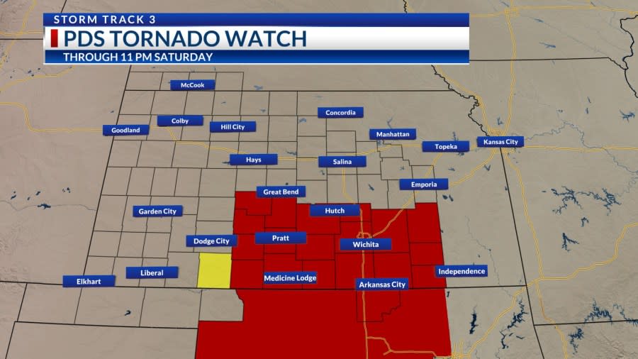
WICHITA, Kan. (KSNW) — A PDS (Particularly Dangerous Situation) tornado watch was issued for several south-central Kansas counties on Saturday until 11 p.m.
KSN Chief Meteorologist Lisa Teachman and meteorologists Lucy Doll and Jack Boston were in the Storm Track 3 Weather Center tracking storm reports across the KSN viewing area on Saturday.
Storm trackers observed a possible tornado in Harper County.
Counties under the PDS tornado watch that are in the KSN viewing area include:
Sedgwick
Sumner
Cowley
Sumner
Reno
Harvey
Pratt
Barber
Pawnee
Stafford
Kiowa
Kingman
Chautauqua
Edwards
Butler
Elk
Greenwood
Harper
Kay (Oklahoma)
There is a tornado watch for other parts of Kansas until 1 a.m. in these counties:
Chase
Dickinson
Geary
Lyon
McPherson
Marion
Morris
Barton
Ellis
Ellsworth
Lincoln
Mitchell
Osborne
Ottawa
Rice
Rooks
Rush
Russell
Salin
Smith
The videos below of damage in Harper County come from KSN storm tracker Jacob Honeycutt.

Storm Reports:
10:23 p.m.
Wind 60 mph – 5 NE Lincoln (Lincoln Co.)
9:51 p.m.
Wind 63 mph – 2 SW Salina (Saline Co.)
9:44 p.m.
Trees and power lines down – Burden (Cowley Co.)
Ping pong ball size hail (1.50″) – Offerle (Edwards Co.)
Half dollar size hail (1.25″) – Buttermilk (Comanche Co.)
Golf ball size hail (1.75″) – Kinsley (Edwards Co.)
Quarter size hail (1.00″) – Medicine Lodge (Barber Co.)
9:29 p.m.
Half dollar size hail (1.25″) – 3 SW Buttermilk (Comanche Co)
Quarter size hail (1.00″) – 1 WSW Kingsdown (Ford Co.) Skylights and window panes broken, window frames dented
Ping pong ball size hail (1.50″) – Medicine Lodge (Barber Co.)
Quarter size hail (1.00″) – 3 ENE Englewood (Clark Co.)
9:23 p.m.
Tree damage 13th and Tyler – Wichita (Sedgwick Co.)
Wind gust 60 mph – Douglass (Butler Co.)
Tree down on 3 vehicles (Unoccupied) – S 14st St./near Old Main St. – Newton (Harvey Co.)
Tree down and Debris at 44 Leslie Lane – Halstead (Harvey Co.)
Wind damage – Trees and debris blocking SW 60th Rd. – 4 NNE Sedgwick (Harvey Co.)
Wind 70 mph – Udall (Cowley Co.)
9:14 p.m.
Flooding outside of KSN studios on N Main St. In Wichita (Sedgwick Co.)
8:59 p.m.
Power lines down 6400 block of W 36th St. Wichita – Arcing line on tree and shed (No injuries) (Sedgwick Co.)
Power pole down on street – 1100 block of W Lydia St. Wichita (No injuries)(Sedgwick Co.)
Power lines down – 3 SSE Wichita (ICT) (Sedgwick Co.)
65 mph wind gust – 3 NNE East Wichita (Sedgwick Co.)
Pole fires reported – W 21st and Ridge – Wichita (Sedgwick Co.)
Pole fires reported – 200 block W 4th St. – Valley Center (Sedgwick Co.)
Tree down 200 block of West 3rd – Sedgwick (Sedgwick Co.)
Tree down 6th and Franklin – Sedgwick (Sedgwick Co.)
Power lines down – Newton (Harvey Co.)
Power lines down – Halstead (Harvey Co.)
Multiple trees down in city of Sedgwick (Harvey Co.)
69 mph winds – 4 ENE Newton (Harvey Co.)
62 mph winds – Colwich (Sedgwick Co.)
8:31 p.m.
Winds gusting to 72 mph at ICT (Sedgwick Co.)
70 mph winds – Conway Springs (Sedgwick Co.)
78 mph winds – 1 N Goddard (Sedgwick Co.)
8 p.m.
KSN storm tracker Jacob Honeycutt said a house and a barn 6.5 miles west of Anthony sustained tornado damage.
7:52 p.m.
Trees and Power Lines down near downtown Arkansas City (Cowley Co.)
7:47 p.m.
Tornado on the ground – 10 WSW Anthony/4 ENE Corwin (Harper Co.)
60 mph winds – 6 N Arkansas City (Cowley Co.)
7:41 p.m.
Hen Egg size hail (2.00″) – 11 NNW Waldron (Harper Co.)
Half Dollar size hail (1.25″) – 6 S Attica (Harper Co.)
Quarter size hail (1.00″) – 5 S Corwin (Harper Co.)
7:22 p.m.
Report of tornado 12 miles west of Anthony in Barber County
7:13 p.m.
Golf Ball hail (1.75″) – 2.25 miles north of Medicine Lodge (Barber Co.)
5:54 p.m.
Golf ball sized hail (1.75″) – K1 on South side of Comanche County
The video below was shot by KSN reporter Derek Lytle in downtown Wichita.
Tracking Severe Weather:
RADARS:
Interactive Radar (Control yourself)
CURRENT WEATHER WARNINGS AND WATCHES
WATCHING THE KANSAS SKIES:
Free apps
KSN Storm Track 3 Weather App:
Google Download
KSN News App:
Social Media:
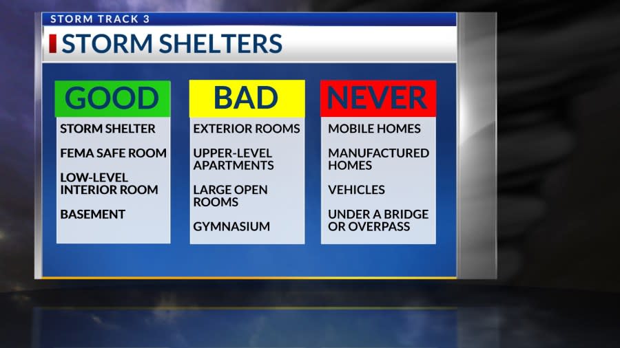
Keeping You Safe:
Copyright 2024 Nexstar Media, Inc. All rights reserved. This material may not be published, broadcast, rewritten, or redistributed.
For the latest news, weather, sports, and streaming video, head to KSN-TV.

