Storm will bring a wintry weekend mix to begin March break in P.E.I.
P.E.I.'s Prince County remains under a special weather statement from Environment Canada as a winter storm makes its way toward the Island this weekend to kick off March break.
While there are no statements or warnings in place for central and eastern parts of the province, those areas will also see messy road conditions and a wintry mix of precipitation.
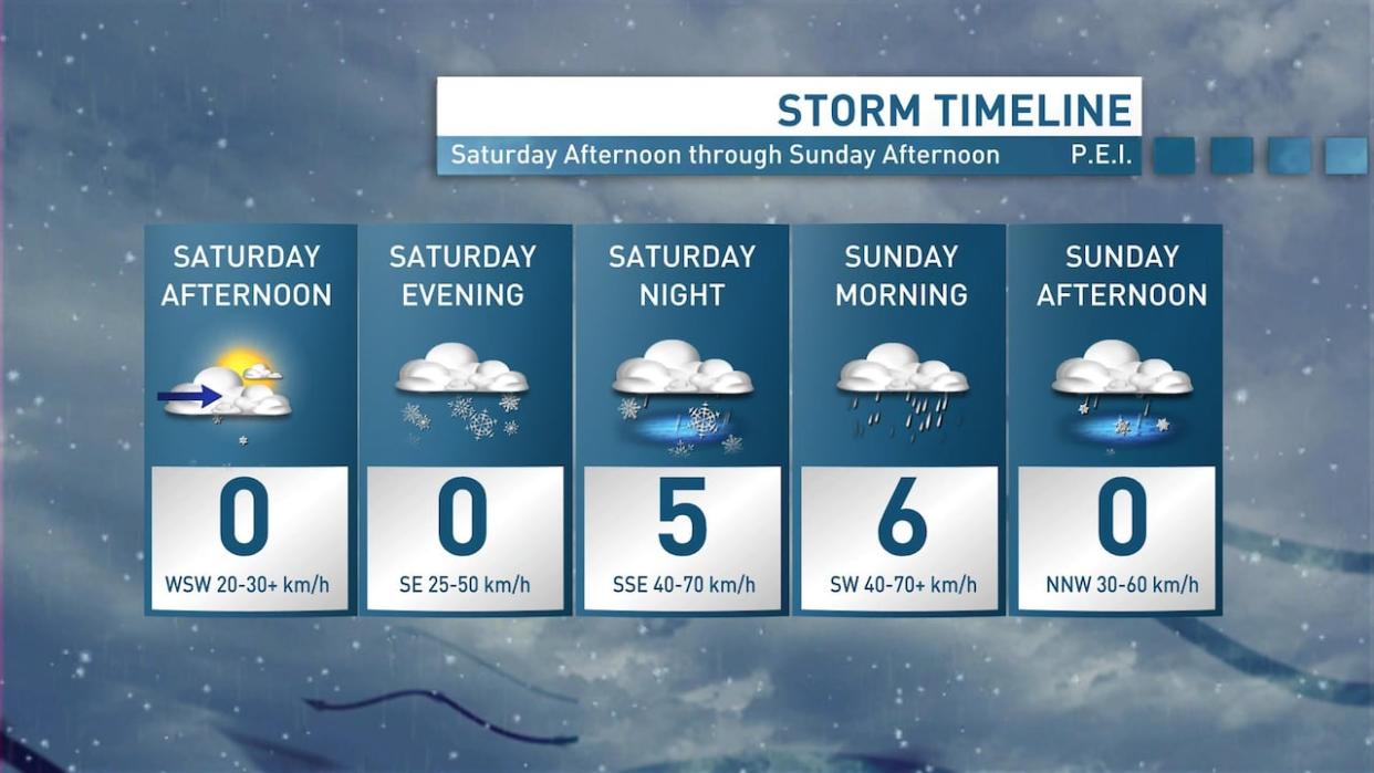
CBC meteorologist Jay Scotland said Islanders will have time to batten down the hatches Saturday morning before snow arrives in the late afternoon and early evening.
"As the temperature begins to climb Saturday night, steady snow will mix to rain overnight for most areas — mainly snow up west with less rain. During the transition from snow to rain, ice pellets and freezing rain will be possible," Scotland said.
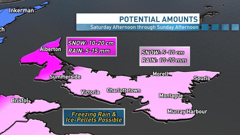
Snow and ice pellet amounts could be between 10 and 20 centimetres in western P.E.I. over the weekend, with between five and 10 centimetres possible for central and eastern areas of the province. (Jay Scotland/CBC)
Sunday will begin wet and windy for most of P.E.I., with periods of rain or a messy mix of rain and snow in Prince County accompanied by south-southwesterly winds gusting between 40 and 70 km/h.
"The temperature begins to fall later [Sunday] morning with a switch to a cold and gusty north-northwesterly wind," Scotland said. "With the temperature near or below freezing by early afternoon, any lingering showers will transition to flurries, and some patchy freezing rain is also possible at that time."
In anticipation of the wind, the Confederation Bridge website warned Friday morning that traffic might have to be restricted at some points over the weekend.
Maritime Electric posted on social media Friday that its crews are ready to respond to any power outages if needed, along with a link to instructions for preparing an emergency kit.
Messy road conditions possible
Scotland said it's difficult to forecast snow and ice pellet accumulations given that temperatures will fluctuate on either side of the freezing mark during the storm.
Still, he said, snow and ice pellet amounts could be between 10 and 20 centimetres in Prince County, with nearly five to 10 centimetres possible for central and eastern areas of the province.
As for rain, most of the Island can expect between 10 and 20 millimetres, although less is likely in western P.E.I. where more snow is expected. Some freezing rain is also possible at times in places where the temperature gets near freezing.
"Please be prepared for messy road conditions at times this weekend, particularly Saturday night and Sunday morning," Scotland said. "Local outages are also possible as it will also be windy, especially Sunday morning."

