P.E.I. hit with snowfall, freezing rain warnings ahead of storm
Environment Canada has issued a freezing rain warning for Kings and Queens counties, as well as a snowfall warning in Prince County, ahead of a storm forecast to hit the Island on Thursday.
For Kings and Queens, the weather agency said precipitation will begin falling as rain Wednesday night before changing over to a mix of freezing rain and ice pellets Thursday morning. That will taper to flurries Thursday evening, making surfaces such as highways, roads, walkways and parking lots icy and slippery and delay transportation.
Prince County residents are warned that rain is expected to develop Thursday evening before quickly transitioning to snow after midnight. There is a risk of freezing rain during this transition, Environment Canada said.
CBC meteorologist Jay Scotland said the wind had already shifted Wednesday afternoon to a cooler, northerly direction, with temperatures gradually falling as a result.

Freezing rain warnings have been issued for P.E.I.'s Kings and Queens counties on Thursday, while Prince County remains under a snowfall warning. (Charles Contant/CBC)
"By midnight, I expect western Prince County will already see this transition occurring, which is why heavier snow and ice-pellet accumulation is likely for the western half of the Island," Scotland said.
"Through the overnight hours into Thursday morning, central and eastern areas will begin to see this transition from rain to snow begin as well, so less snow is likely, but there is a higher chance for more mixed precipitation and even significant freezing rain."
Charlottetown Airport issued an advisory that the weather system could affect flights on Wednesday night, Thursday and Friday. It advised travellers to check with their airline directly for any changes or cancellations.
The type of precipitation is temperature-dependent, making forecasting precipitation amounts tricky, Scotland said.

Scotland said conditions should improve Thursday night into Friday morning. (Jay Scotland/CBC)
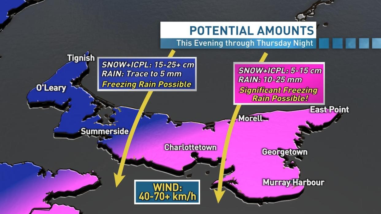
For western P.E.I., an additional 5 mm of rain is possible Wednesday night, followed by 15 cm to 25-plus cm of snow and ice-pellet accumulation overnight through Thursday. While the risk isn't as high as eastern areas, some freezing rain is also possible up west as well during the transition from rain to snow.
For the eastern half of the Island, additional rainfall in the 10 to 25 mm range overnight and into early Thursday is possible, followed by snow and ice-pellet accumulation near 5 cm to as much as 15 cm by Thursday night. There is also a risk of significant freezing rain, which may be a prolonged event for some areas Thursday morning and afternoon, before the steadier precipitation tapers to flurries Thursday night.
"My main concerns for tonight and Thursday are for local flooding then for icy and/or snow covered roads and sidewalks," Scotland said.
"As the wind picks up later in the day Thursday ... blowing snow and power outages are also possible. Conditions should improve Thursday night into Friday morning, but icy surfaces and blowing snow may be an issue for some areas even on Friday."

