Severe weather, tornado risk shifts to Atlantic coast to Midwest on Thursday


The same intense storm system responsible for over a foot of rain and violent winds and tornadoes in the southern United States into Wednesday night will continue to spin along and threaten the Eastern Seaboard and stretch through part of the Midwest with severe weather into Thursday evening, AccuWeather meteorologists warn. Close to 75 million people may be at risk of severe weather.
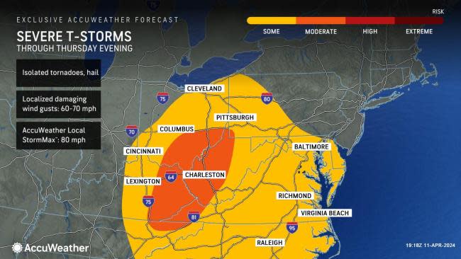
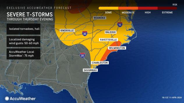
Two main zones of severe weather will likely take center stage into Thursday evening. Some communities from the coastal Carolinas to Delaware and areas from eastern Kentucky, northeastern Tennessee and West Virginia to Ohio and western Pennsylvania can be hit hard. However, heavy to locally severe thunderstorms will likely erupt in between the two zones over a portion of the central Appalachians.
 |
All modes of severe weather are possible, ranging from high winds and hail to flash flooding and a few tornadoes in both the East Coast and Midwest zones.
Some of the most vigorous thunderstorms to start the day Thursday were located in northern Florida, where periodic severe thunderstorm and tornado warnings were issued.
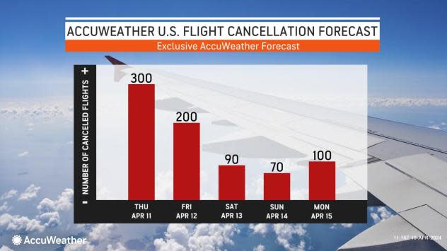
As the storms cross major highways, such as interstates 64, 70, 77, 95 and many others, sudden poor visibility from torrential downpours and high winds with ponding will be hazards for motorists. Meanwhile, as the storms approach and pass through the major airport hubs in the East and Midwest, significant airline delays and flight cancellations are likely.
The storm system has had a history of producing copious amounts of rain and triggering flash flood emergencies. New Orleans was inundated with up to a few feet of water as relentless downpours overwhelmed the stormwater pumps on Wednesday. The storm system continued to cause flash flood dangers farther to the east along the Interstate 10 corridor Wednesday night. The flash flood threat shifted to the I-95 zone on Thursday morning.
 |
Since the parent storm system will continue to strengthen as it pushes across the Great Lakes into Thursday night and Friday, atmospheric dynamics will create problems without thunder and lightning in some cases.
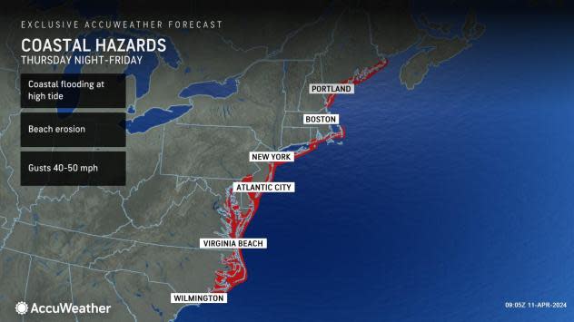
Strong winds will ramp up along the Atlantic coast. The winds, when combined with heavy rain, will make for difficult travel and flash flooding while triggering power outages and coastal flooding at times of high tide north of the severe thunderstorm zone from the upper mid-Atlantic to New England from late Thursday to Friday.
 |
Meanwhile, the strengthening low pressure will create strong winds around the Great Lakes region, which can lead to lakeshore flooding, as well as sporadic power outages from the Midwest to the Southeast states.
Those traveling on the highways and taking to the air can expect significant delays in cities such as Washington, D.C., Philadelphia, New York City, Boston, Pittsburgh, Detroit, Chicago, Cincinnati, Orlando, Charlotte and Atlanta. Airline delays can result from direct severe weather impacts or ripple effects as crews and aircraft are displaced.
 |
Even in the wake of severe weather and heavy rain, gusty winds can lead to problems associated with sporadic power outages over the South Central and interior Southeast states.
Want next-level safety, ad-free? Unlock advanced, hyperlocal severe weather alerts when you subscribe to Premium+ on the AccuWeather app. AccuWeather Alerts™ are prompted by our expert meteorologists who monitor and analyze dangerous weather risks 24/7 to keep you and your family safer.
