Severe weather packs a punch as powerful storms press into eastern US


Following a very active and dangerous Monday night due to severe weather over parts of the central United States, the risk of severe weather will continue on Tuesday and Wednesday as the threat shifts farther to the east, AccuWeather meteorologists caution.
There were at least three reports of tornadoes in Oklahoma alone on Monday evening. Hail to the size of grapefruits fell on Wise County in central Texas. Incidents of hail extended from central Texas to southern Ohio. Wind gusts near 90 mph were reported in some of the strongest storms in Texas.
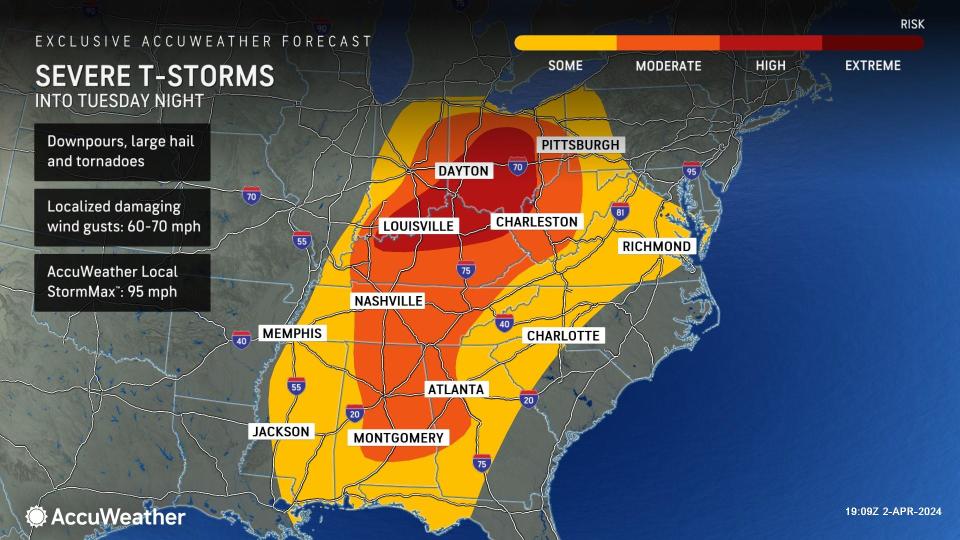
The risk to lives and property will continue on Tuesday and Tuesday night following powerful thunderstorms that produced large hail and tornadoes from the southern Plains to the middle Mississippi Valley.
The threat of tornadoes will extend into somewhat heavily populated areas on Tuesday.
The severe weather threat into Tuesday night will extend from the northern parts of Indiana and Ohio and western Pennsylvania, southward to the central Gulf coast and eastward to the Chesapeake Bay region. Storms in this broad zone will pack strong wind gusts, hail and localized flash flooding.
The greatest threat of tornadoes will extend from central Tennessee to part of southeastern Indiana, central Ohio and western West Virginia and includes much of central and eastern Kentucky. Multiple tornadoes could be spawned in this rather heavily-populated zone. However, any severe thunderstorm outside of this area has the potential to produce a brief tornado.
 |
The major cities of Nashville, Cincinnati, Columbus, Ohio, and Charleston, West Virginia, are among the metro areas at risk for violent storms on Tuesday.
AccuWeather meteorologists are keeping a close eye on a disturbance in the jet stream that may spark a secondary pocket of severe weather farther to the east in parts of Georgia and the Carolinas on Tuesday. If this develops to its full potential, a second zone where tornadoes develop may be possible.
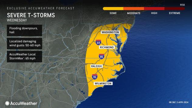
"On Wednesday, it appears the primary threat for severe thunderstorms will be for strong wind gusts, and that will be centered on a large portion of the mid-Atlantic coast," AccuWeather Meteorologist Alyssa Glenny said.
 |
Wednesday's strongest storms will focus from southern New Jersey, Delaware and northeastern Maryland, southward through much of central and eastern Virginia, central and eastern North Carolina and part of eastern South Carolina. The risk includes the cities of Baltimore; Washington, D.C.; Cape May, New Jersey; Wilmington, Delaware; and Wilmington, North Carolina.
The AccuWeather StormMax™ wind gust is 65 mph on Wednesday.
Outside of severe thunderstorms from the middle to late parts of the week, high winds from a powerful storm system will affect a large part of the Northeast. The winds may be strong enough to bring down trees and power lines, even outside of the heavy snow area in northern New England and upstate New York.
Want next-level safety, ad-free? Unlock advanced, hyperlocal severe weather alerts when you subscribe to Premium+ on the AccuWeather app. AccuWeather Alerts™ are prompted by our expert meteorologists who monitor and analyze dangerous weather risks 24/7 to keep you and your family safer.
