West Virginia Spring Severe Weather Awareness Week: Thunderstorms


(WVNS) — Your Weather Ready Nation Ambassador weather team, StormTracker 59, is once again participating in a week-long Severe Weather Awareness event hosted by the National Weather Service – Charleston. During this week long special we hope to help your family be prepared for severe weather. Something we see year long, every year here in our region.
For Monday, March 18th, we look at thunderstorms and the risks they bring:
Thunderstorms
We see thunderstorms in our region every year and sometimes they become severe. A thunderstorm becomes severe when the thunderstorm contains one or more of the following threats to an area that would threaten us, our property and surroundings:
Producing hail that is an inch or larger.
Wind gusts in excess of 58 mph (50 knots).
The thunderstorm lifecycle is part of a three stage process:
Cumulus Stage: Warm air rises, and this upward motion helps form cumulus clouds. During the middle of the summertime, when heat and humidity pop isolated storms, this is commonplace to see and usually begin as small cumulus clouds that gradually grow in size. The updraft (a small-scale current of rising air) slowly increases in strength, enabling the cumulus cloud to grow in size.
Mature State: Cumulus clouds continue to grow in size and the key components that allow a thunderstorm to thrive are developed – a strong updraft and downdraft (small-scale current of air that rapidly sinks to the ground) are now present in the storm. This is the stage where the peak in thunderstorm strength is present.
Dissipating Stage: The thunderstorm begins to weaken because the storm becomes downdraft dominant.
Is it safe to shower during a thunderstorm?
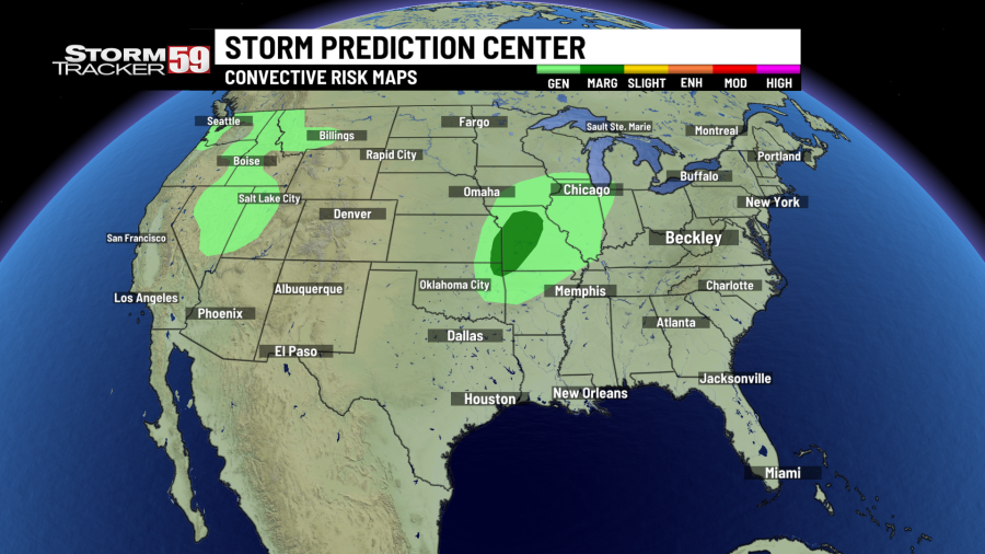
One way the StormTracker 59 weather team helps articulate the threat for severe weather in our region is by use of the Storm Prediction Center’s convective outlooks. This is a forecast that denotes both non-severe and severe thunderstorm threats across the contiguous United States.
Why does thunder have different sounds?
The level of categorical risk for severe weather used by the Storm Prediction Center is as follows:
General Thunderstorm (Light green) – General or non-severe thunderstorms, where a 10 percent or greater probability of a thunderstorm is forecast during the period.
Marginal (Dark green, level 1) – An area of severe storms of either limited organization and longevity, or very low coverage and marginal intensity.
Slight (Yellow, level 2) – An area of organized severe storms, which is not widespread in coverage with varying levels of intensity.
Enhanced (Orange, level 3) – An area of greater severe storm coverage with varying levels of intensity.
Moderate (Red, level 4) – An area where widespread severe weather with several tornadoes and/or numerous severe thunderstorms is likely, some of which should be intense. This risk is usually reserved for days with several supercells producing intense tornado and/or very large hail, or an intense squall line with widespread damaging winds.
High (Magenta, level 5) – An area where a severe weather outbreak is expected from either numerous intense and long-tracked tornadoes or a long-lived derecho-producing thunderstorm complex that produces hurricane-force wind gusts and widespread damage. This risk is reserved for when high confidence exists in widespread coverage of severe weather with embedded instances of extreme severe weather (violent tornadoes, for example).
In addition to the convective outlook being issued by the Storm Prediction Center, the SPC also issues individualized severe weather risks, which we display graphically. These types of individualized severe weather risks include tornadoes, hail, winds and flooding and range in risk from low to elevated to high and major. The percentage probabilities shown below for each severe weather risk is the probabilistic forecast of a severe weather event occurring within 25 miles of a point.
Tornadoes: Low 2%, Elevated 5%, High 10%, Major 15%
Hail: Low 5%, Elevated 15%, High 30%, Moderate 45%
Winds: Low 5%, Elevated 15%, High 30%, Moderate 45%
Flooding risks are assessed by the Weather Prediction Center (WPC) for flood risks on lakes, streams, and rivers.

We see watches and warnings for severe weather issued usually at least a few times every season in the two Virginias. But do you know the difference between the two of them?
A Severe Thunderstorm Watch is issued when severe thunderstorms are possible in and near the watch area. The watch area is usually quite large, covering many counties or even states and the duration is usually over several hours. A Severe Thunderstorm Warning is issued when severe weather has either been reported by a spotter or is indicated by radar. Warnings indicate imminent danger to life and property. Take cover. Warnings usually cover a much smaller area than a watch, such as the size of a county and they typically only last up to an hour for the severe thunderstorm in question that is imminently approaching to roll through.

In essence, a watch means that the ingredients for severe weather are there, and that severe weather could happen, while a warning indicates that severe weather is either already occurring or is likely to occur.

When a Severe Thunderstorm Watch is issued, you do not need to take shelter immediately and there is a good chance that severe weather has not been reported yet. However, make sure to have a plan for if severe weather works into your area, such as a plan of where to head to in your home to take cover. You should also closely monitor weather conditions. When a Severe Thunderstorm Warning is issued, severe weather has either been indicated or reported and you’ll want to take cover in a place in your home that is safe for you and your family (preferably downstairs and/or away from windows). Knowing the difference between the two is crucial to planning ahead to stay safe when the threat for severe weather strikes.
Damaging Winds
Over the last twenty years in West Virginia, 4,427 reports of damaging wind have been recorded, which averages out to about 220 per year. Out of the severe weather hazards (tornadoes, damaging wind gusts, hail), this is by far the most common that we see. A damaging wind gust is defined by the National Weather Service as a severe thunderstorm wind gust between 58 mph and 74 mph.

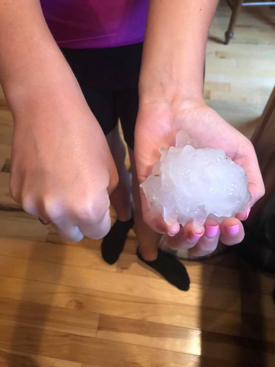
Damaging Hail
We see hail of just about all shapes and sizes in the Mountain State, with 1,089 reports of severe hail alone in the last 20 years. Severe hail is defined by the National Weather Service as being one inch or greater in diameter. Hail sizes are attributed to many different types of objects, including:

Pea: 1/4″ diameter
Mothball: 1/2″ diameter
Penny: 3/4″ diameter
Nickel: 7/8″ diameter
Quarter: 1″ diameter (considered severe)
Ping-Pong Ball: 1 1/2″ diameter
Golf Ball: 1 3/4″ diameter
Tennis Ball: 2 1/2″ diameter
Baseball: 2 3/4″ diameter
Tea Cup: 3″ diameter
Softball: 4″ diameter
Grapefruit: 4 1/2″ diameter
Occasionally, extremely large hailstones will fall in thunderstorms with very intense updrafts. In recent years, the second largest recorded hailstone in West Virginia history fell in central West Virginia in Kanawha County in May 2019, when hailstones 4 1/4″ in diameter fell. The biggest hailstone recorded in our state was a 4 1/2″ grapefruit-sized hailstone spotted in McDowell County in 1980.
Lightning
Lightning forms when warm air rises, producing storm clouds. Ice particles and water droplets collide in the clouds and these collisions create positive and negative charges in the cloud. The ground has a positive charge. When the energy from the negative charge meets the leader from a positive charge, you see a flash.


Cloud top: Positive charge
Cloud bottom: Negative charge
The reason we will say ‘when thunder roars, go indoors’ is because lightning can strike from any part of the thunderstorm anvil. The anvil of a thunderstorm sometimes is several miles away from where the precipitation is located. This is commonly called ‘blue lightning’ because the lightning occurs ‘out of the blue’. These are usually the deadliest strikes. On average, 28 people die from lighting every year according to the CDC.
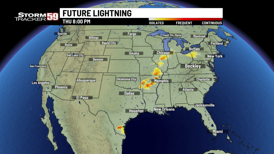
One feature available exclusively from the StormTracker 59 weather lab is our future lightning product, which estimates which areas will see not only the chance for lightning, but which areas are most likely to see frequent lightning. This is a product that takes many variables into consideration and can help keep you and your family safe by letting you know when lightning is possible in your area.
The StormTracker 59 team has you covered to help keep you and your family safe when the threat for severe weather is possible! There are multiple ways of staying up to date with us on the latest warnings for our region that would indicate this potential threat:
On air on WVNS-TV 59 on CBS at 5 AM, 6 AM, 12 PM, 5 PM, 6 PM and 11 PM Monday through Friday and 6 PM and 11 PM on the weekends.
On air on WVNS-TV 59 on Fox at 10 PM Monday through Sunday.
Online on our website here, where you can see the latest watches, warnings, forecast discussions, videos, current data and so much more!
The StormTracker 59 mobile app, free on the Apple and Google Play.
The StormTracker 59 Facebook page and Twitter page.
After the storm, when safe to do so, your voice, photos, and video can be some of the best resources your local, state, and federal meteorologists have in determining what caused storm damage. It can even be the only look we have at what is going on at ground level when severe weather strikes. For StormTracker 59 we make sharing these easy via social media, email at weather@wvnstv.com, or our community photo album on our website. Weather Together is free and easy to share photos with us and your community. Try it out for yourself here.

For the latest news, weather, sports, and streaming video, head to WVNS.

