Severe storms to return to central US


Rounds of severe thunderstorms through the end of the week in the southern and central United States may fall well short of the outbreak magnitude and intensity of recent weeks. However, AccuWeather meteorologists warn that the storms can still be dangerous, damaging and locally disruptive.
New episodes of severe weather will follow heavy, gusty and locally damaging thunderstorms that erupted from the Ohio Valley to Florida into Tuesday evening.
Severe weather will be bolstered by a somewhat stronger storm system to push out of the Rockies and onto the central Plains at midweek. This same storm will then continue to push eastward Thursday and Friday, triggering severe weather at least at a local level in parts of the Mississippi Valley and central Gulf Coast region.
The storms into Wednesday night packed strong wind gusts and large hail. Downpours led to sudden low visibility for motorists on the highways.
 |
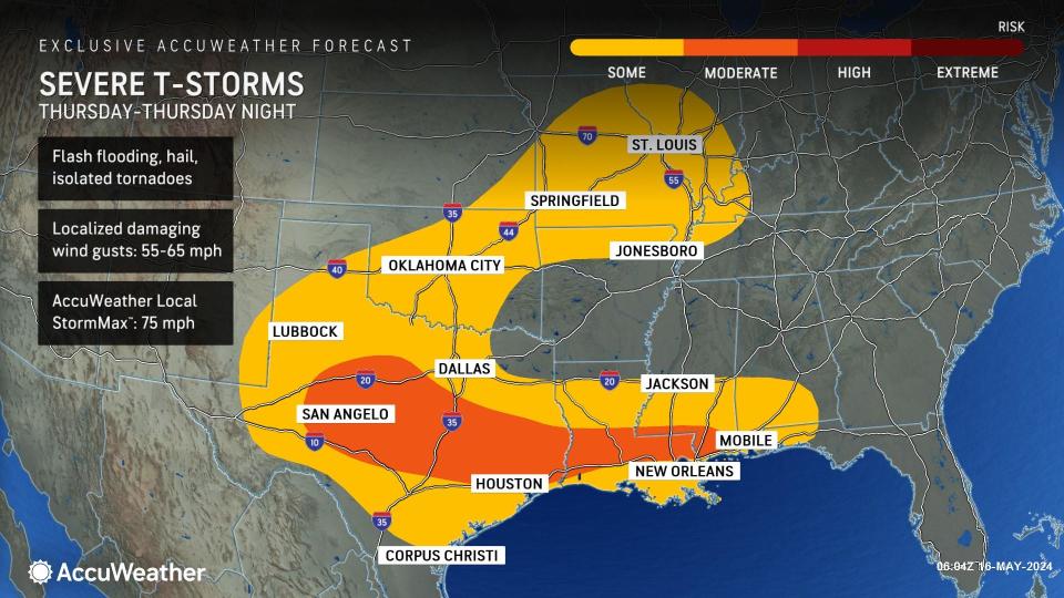
As the storm progresses, the risk of severe weather Thursday and Thursday night will extend from central Texas and Oklahoma to much of the Texas coast, much of Louisiana and southern Mississippi and Alabama.
Depending on where an organized complex of severe thunderstorms develops, portions of central Texas to northeast Texas and central and southern Louisiana could be hit hard with damaging weather conditions.
Another leg of locally severe storms will extend from Oklahoma to southeastern Kansas, northern Arkansas, much of Missouri and portions of Tennessee, Kentucky, Illinois and Indiana.
The strongest storms will carry the risk of high wind gusts, hail and a few tornadoes. As downpours from the storm reach areas where the ground is saturated from recent rain, the risk of flash flooding and flooding in general will escalate.
 |
On Friday, the risk of severe weather will settle over the lower Mississippi Valley and much of the upper Gulf Coast. As in prior days, the strongest storms may bring powerful wind gusts, hail and a few tornadoes. The likelihood of flash flooding will continue to escalate as heavy rain falls on widespread areas of saturated ground and where streams and rivers remain swollen.
Looking ahead, more relatively small areas of severe weather will continue to affect the Central and Southern states through next week. However, AccuWeather's Long-Range team of meteorologists expects the risk of larger, significant outbreak-level severe weather events to resume toward the end of May and last into mid-June. The severe weather risk could expand to more of the East during that time.
As of the start of May 14, there have been more than 6,707 preliminary reports of severe weather, including 784 reports of tornadoes, according to the Storm Prediction Center (SPC). While the number of hail and damaging wind gust incidents is running close to the historical average, the tornado count to date is about 200 incidents higher than the historical average for mid-May.
Want next-level safety, ad-free? Unlock advanced, hyperlocal severe weather alerts when you subscribe to Premium+ on the AccuWeather app. AccuWeather Alerts™ are prompted by our expert meteorologists who monitor and analyze dangerous weather risks 24/7 to keep you and your family safer.
