Powerful tornadoes tear across Nebraska and Iowa as weather service warns of ‘catastrophic’ damage
Devastating tornadoes are tearing across parts of eastern Nebraska and Iowa on Friday as a multiday severe thunderstorm event ramped up in the central United States, injuring at least three people.
Storms began in parts of the Plains and South early Friday afternoon. The National Weather Service had received at least 60 reports of tornadoes in at least five states as of 9:30 p.m. ET, making today the busiest day for tornadoes in the US in more than a year.
In addition to tornado warnings, there have been 19 damaging wind reports and 45 hail reports from Friday’s severe weather outbreak. Three of those hail reports were at least 2 inches in diameter, approximately lime-sized.
Here’s what we know so far:
• Iowa Governor Kim Reynolds has issued a disaster proclamation for Pottawattamie County in response to Friday’s severe weather. In a tweet, the Republican governor said the proclamation was to support storm recovery efforts in the town of Minden. Tornado warnings were in effect for portions of the Des Moines metro area as of 9:45 p.m. ET.
• On Friday, a tornado roared through the outskirts of Lincoln, Nebraska, tearing the roofs off homes and crossing part of I-80 in the process. An overturned tractor-trailer, blown over by the storms, brought traffic to a slow crawl on the interstate, traffic cameras showed.
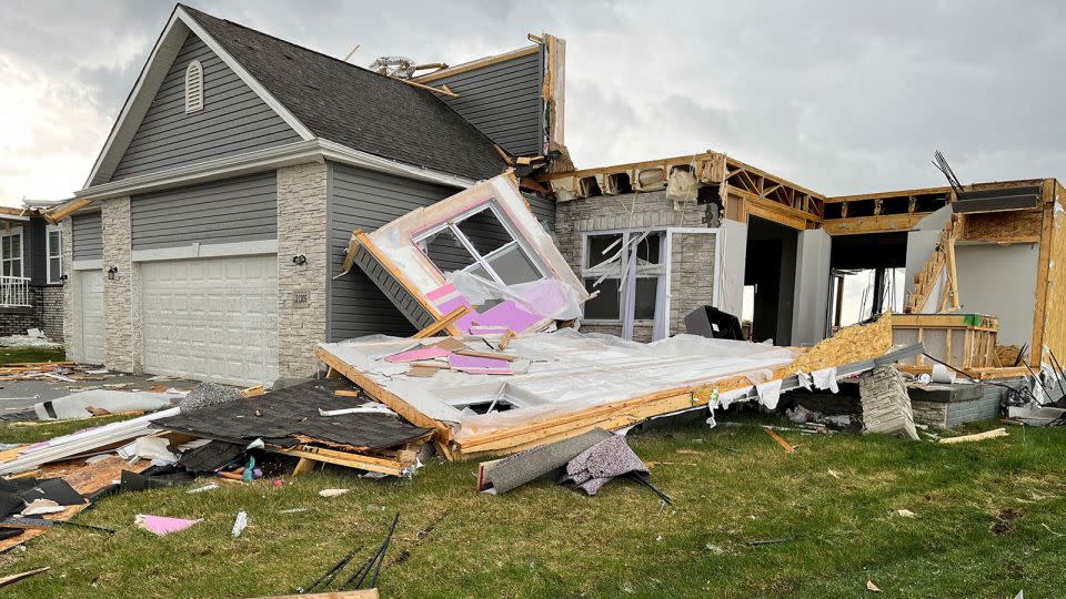
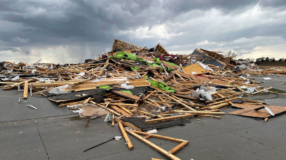
• In Elkhorn, an area on the edge of Omaha, first responders are still combing through the wreckage left behind by the tornado, searching through flattened homes for anyone trapped or injured, local authorities announced at a Friday news conference. The area is grappling with power outages, gas leaks, toppled trees, and unstable structures. Two people were transported for medical treatment with minor injuries. “We think injuries were so little because the warning systems in the City of Omaha and Douglas County were highly effective,” Omaha Police Chief Todd Schmaderer said. “We were not hit with a sudden storm. People had warned of this, which saved lives, in our opinion.”
• One storm chaser described a “very devastating situation” after a tornado barreled through Elkhorn. “Some houses have been swept and no longer exist,” Thomas Hinterdorfer told CNN. “Most homes in this immediate area have suffered significant damage and it’s likely going to be a long clean up effort.”
• Shelby and Douglas County emergency management officials in Nebraska said they have received no reports of severe injuries from Friday’s storms. Alex Londo, Shelby County’s emergency coordinator said there has been substantial property damage. “First responders are out assessing the needs at this time,” Londo told CNN. And Leia Baez, communications director for Douglas County, said there were no serious injuries or fatalities from the tornadoes in Elkhorn, Bennington and Waterloo but many homes were severely damaged, displacing residents. An American Red Cross shelter has been opened in Elkhorn.
• Omaha’s Eppley Airfield, the largest airport serving the region, was briefly closed Friday so officials could do a damage assessment, according to a post on X. The airport reopened around 6 p.m. local time after closing “due to storm activity”, according to Tim Schmitt, Chief Operations Officer with Omaha Airport Authority. Some planes and hangars were damaged, he added. In a statement, the airport said passengers in the terminal were placed in storm shelters ahead of the tornado and no injuries were reported.
• Multiple cars of a train derailed near Waverly, Nebraska, after it was struck by a tornado, according to a railway spokesperson. Burlington Northern Santa Fe railway personnel were at the site Friday working to clear the area.
• At least two tornadoes were observed in Texas Friday afternoon, one northeast of Waco. Video of the twister posted to social media showed it churning across a large field.
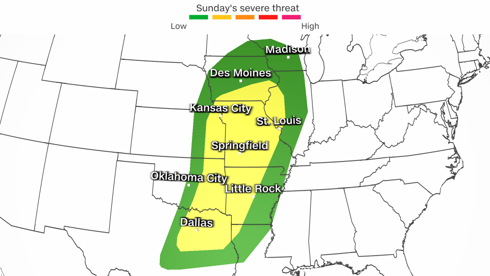
Serious storms are expected to continue through Sunday, but Saturday might be the most dangerous day, when the threat will extend from Michigan to Texas, including Oklahoma City, Kansas City, Dallas, Milwaukee, Chicago and Austin. The storms may bring damaging wind gusts, hail up to the size of baseballs and strong tornadoes.
Some of the same areas hit by storms Friday could be back in the path of storms Saturday, including southeastern Nebraska, southern Iowa, eastern Kansas, and northeastern Texas. In total, more than 50 million people are under the threat of severe weather Saturday.
It’s all part of classic springtime setup for severe weather. Moist air from the Gulf of Mexico is flowing into the central US as heat builds in the region, priming the atmosphere for robust storms.
Some locations are facing a severe thunderstorm threat spanning two or three consecutive days.
Dallas; Kansas City, Missouri; Des Moines, Iowa; and Omaha, Nebraska, are just a few cities that could be hit by multiple rounds of severe thunderstorms through Sunday.
Friday: Plains, Mississippi Valley, Midwest
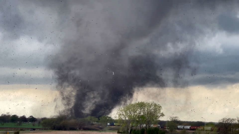
Destructive storms lit up radars and brought parts of eastern Nebraska to a standstill Friday afternoon. Tornado sirens blared as a line of supercell thunderstorms raked through the Lincoln and Omaha areas, some of which produced what appeared to be massive, damaging tornadoes.
Tornadoes continue to spawn Friday evening as storms track east into Iowa and northern Missouri. The National Weather Service issued a tornado emergency for a large tornado that was confirmed near Harlan, Iowa. Meteorologists noted it was a “particularly dangerous situation” in which “catastrophic damage” was likely.
A Level 3 of 5 risk of severe thunderstorms extends from parts of Iowa and Nebraska south into northeast Texas. Storm will track east into Iowa and Missouri through the evening and into the overnight.
Damaging wind gusts, hail up to the size of baseballs and strong tornadoes – at least EF2-strength – are possible with any storm in the Level 3 of 5 risk area.
“Several factors appear to be supportive of a significant tornado event today,” the prediction center warned Friday morning. The tornado risk will continue to increase into the evening hours.
Heavy rainfall with rates up to 2 inches per hour could cause flooding in parts of Texas, Oklahoma, Arkansas and Missouri.
Parts of Missouri were deluged with rain on Thursday, prompting flash flood warnings in the Springfield area, where more than half a month’s worth of rain fell. Additional heavy rainfall Friday could allow floodwaters to rise faster and pose an even greater hazard.
Saturday: Potential to be the most dangerous day
Saturday could be the most dangerous day of the four if certain atmospheric conditions align. The potential strength of storms hinges on how Friday night’s storms evolve and linger into Saturday morning.
“A complex but potentially significant severe weather episode is expected on Saturday,” the prediction center cautioned Friday.
If storms hang around in the morning hours, the atmosphere will not be able to fully recharge to unload widespread, dangerous storms. Damaging storms are still likely in this scenario, they could just fail to reach their peak potential strength.
But if storms quickly clear out Saturday morning, there won’t be much of a limit on how strong storms could become.
The most significant storms are possible starting in the afternoon in parts of the southern and central Plains, where a Level 3 of 5 risk of severe thunderstorms is in place. Widespread damaging wind gusts, hail up to the size of baseballs and strong tornadoes are the storms’ main hazards.
The tornado threat could ramp up considerably through the late afternoon and evening hours with “multiple strong tornadoes” possible, according to the prediction center.
Damaging storms are possible outside of the greatest risk area in a huge area of the country from the Great Lakes to southern Texas.
A “significant rainfall event” could unfold Saturday, the Weather Prediction Center warned. Some locations could record close to 5 inches of rain in a short period and dangerous flash flooding could result. A handful of locations caught under multiple rounds of gushing rainfall could have totals approach the 8-inch mark.
A Level 3 of 4 risk of excessive rainfall is in place for a large portion of Oklahoma – including Oklahoma City and Tulsa – and smaller parts of Kansas and Texas. Intense rainfall could force streams to overflow their banks and flood roadways.
Sunday: Plains, Mississippi Valley, Midwest
Damaging storms are possible from Texas to Wisconsin Sunday. But the exact timing, extent and strength of these storms will depend heavily on how Saturday night’s storms behave.
If the atmosphere is able to recharge following morning storminess, new severe thunderstorms will start to bubble up in the afternoon. Areas from northeastern Texas to southern Iowa and western Illinois face the greatest chance for damaging storms.
The storms could unload damaging wind gusts and large hail, but an isolated tornado or two is also possible.
Some storms, especially in the southern portion of the risk area, could remain severe as they push east Sunday night.
Heavy, flooding rainfall is possible, especially in parts of the Lower Mississippi Valley.
By Monday, severe weather is forecast to become much more isolated. Any developing storms may be confined to the Gulf Coast.
This is a developing story and will be updated.
CNN Meteorologist Robert Shackelford contributed to this report.
For more CNN news and newsletters create an account at CNN.com

