Seven-day taste of early-summer weather in eastern Ontario, Quebec
With the Victoria Day holiday coming up for a good portion of the country, a well-timed stretch of early, summer-like temperatures is coming to parts of Central Canada.
Eastern Ontario and southern Quebec have already enjoyed a pleasant couple of days of 20-degree weather this week, on Tuesday and Wednesday, kicking off a prolonged period of similar warmth for the regions.
DON'T MISS: Victoria Day weekend swim? Water temperatures may 'cool' off plans
The stretch will continue for the next seven days, with temperatures exceeding 20 C forecast through Wednesday, May 22.
To find out when Ottawa, Ont., saw its last extended period of such values, you have to go back to September and October 2023. It lasted from Sept. 28 to Oct. 6.
As for how warm conditions will get during this current stretch for eastern Ontario Quebec, as of now, Monday and Tuesday look to peak at 24 C –– potentially the mildest temperature for Ottawa so far this year.
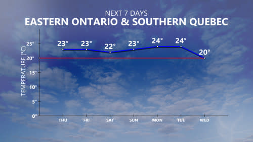
Montreal’s warmest temperature of 2024 so far has been a 21.9 C reading that was recorded on April 12, a value that is expected to be surpassed over the next six days with a peak forecast between 22 C and 24 C.
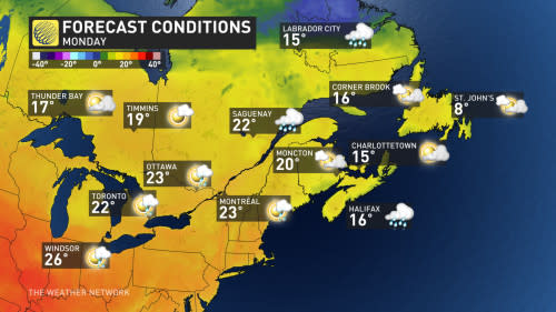
Elsewhere in Ontario, southwestern sections and the Greater Toronto Area (GTA will be around seasonal during this time period, but not quite as warm as eastern locales.
We mentioned the temperatures for the next week, but what about the conditions eastern Ontario and Quebec can expect in the short range?
Well, the weekend will kick off with mostly sunny skies during the day Friday, but showers and thunderstorms will approach eastern Ontario and western Quebec late in the evening, then tracking west to east in the overnight.
The rest of the weekend will be mostly improved from there, with mainly sunny skies but we can't rule out the chance of isolated showers and thunderstorms at times, but it will be mostly precipitation-free.
So, enjoy the next seven days as the long-range forecast looks to tumble down a bit afterwards during the last week of May.
WATCH: Big damage to Ontario family farm after severe storm
With files from Matt Grinter, a meteorologist at The Weather Network.

