Sea levels are starting to rise faster. Here’s how much South Florida is expecting
Sea levels are rising, swamping roads and homes in South Florida. And it’s picked up the pace in recent years.
In the last 80 years, sea level rise has risen about a foot, with 8 inches of that total in the last 30 years, said Brian McNoldy, a senior research associate at the University of Miami’s Rosenstiel School of Marine, Atmospheric and Earth Science.
According to the National Oceanic and Atmospheric Administration’s best estimates, that pace is expected to speed up — dramatically.
It took about 80 years for the first foot. The second one will only take 30 years. The next, 20 years. And Florida could see the next foot in merely a decade after that.
“Sea level rise is beginning to speed up a bit,” McNoldy said. “If you draw a straight line it starts to not look so straight in recent decades.”
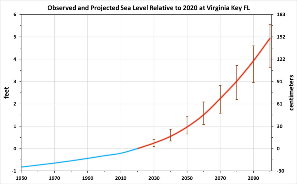
That’s according to NOAA’s “intermediate-high” projection of sea level rise. The agency created a range of predictions — low, intermediate-low, intermediate, intermediate-high and high — to estimate what sea level rise could look like in places like Florida.
So far, scientists have found that we’re trending toward the high end of those predictions.
“Presently, sea level is tracking in the intermediate-high to high, the two fastest,” said Randall Parkinson, a coastal geologist with Florida International University. “The other three scenarios, you might not even think about because we’re already rising faster than that.”
Those are the same predictions used by South Florida governments when deciding how high to build new developments. But after a new bill signed by Gov. Ron DeSantis this year, local governments hoping for state money for sea rise projects have to only consider the intermediate-low and intermediate scenarios, a downgrade from previous legislation that asked them to consider intermediate-low and intermediate-high scenarios.
What goes into a sea rise projection?
Two feet of sea rise by 2060, compared to present-day levels, would be a shock to the system for Miami, where the average elevation is three feet. That’s why local governments — and the state — are spending billions to keep streets dry.
However, pinning down exactly how much sea rise South Florida could experience is a tough task.
Researchers know the two main factors in sea level rise are the temperature of the ocean and how much the ice sheets melt. As burned fossil fuels trap more heat in the atmosphere, that heat is largely being absorbed by the ocean. Hotter water physically takes up more space than cold water, so a hotter ocean means higher sea levels. A hotter atmosphere also means gigantic ice sheets in Greenland and Antarctica are melting, pouring tremendous amounts of now-liquid water into the sea.
Those two issues make up the lion’s share of impact to rising sea levels, but South Florida also has its own unique challenges that add to rising water levels.
READ MORE: Sea levels are rising, but is South Florida also sinking? What the research shows
There’s the fact that some parts of the land are actually sinking, a process known as subsidence. However, it’s not very much — the depth of two credit cards stacked on top of each other over half a decade in one spot in Miami Beach.
“It does add to an already dire situation, but it isn’t a driving force,” Parkinson said.
The one big unknown in South Florida’s future of sea level rise is likely the water rushing offshore. The Gulf Stream, a massive current that moves hot water from the tropics to the frigid depths of the Arctic, has a little offshoot that runs between Florida’s east coast and the Bahamas.
The Florida Current, as it’s known, has an impact on Miami’s water levels. When the current is stronger, water levels are generally a bit lower in Miami. And when it’s weaker, they have been shown to rise.
A new paper from Lisa Beal, professor of ocean sciences at UM’s Rosenstiel School, and Chris Piecuch, a physical oceanographer at the Woods Hole Oceanographic Institution, found for the first time that this current may be slowing down.
“We found that there is a weakening. It’s small,” she said.
The article, published in the journal Geophysical Research Letters in September, suggested that the Gulf Stream has slowed by about 4% in the last 40 years, although it did not directly link that change to global warming.
Beal said the findings were significant for Florida.
“We shouldn’t get carried away that weakening of the Gulf Stream is going to double sea level rise in Miami. It isn’t,” she said. However, “when you’re so low-lying like South Florida, you’d kind of want to know because it means you reach thresholds of flooding much more quickly.”
But perhaps the biggest uncertainty in future sea level rise boils down to one thing: exactly how much more pollution the world will continue to spew into the atmosphere. The lower-end predictions account for a world in which governments stop burning fossil fuels quickly, and the higher-end predictions are based on a situation where we burn even more than we are now.
“One of the great unknowns is, the world needs to be attempting to slow down the release of greenhouse gasses,” McNoldy said.

