Satellites capture smoke pouring from hundreds of wildfires across North America (photos)
Hundreds of wildfires have been blazing across Canada and Mexico since last week, and new satellite images released by NASA show the smoke pouring out of some.
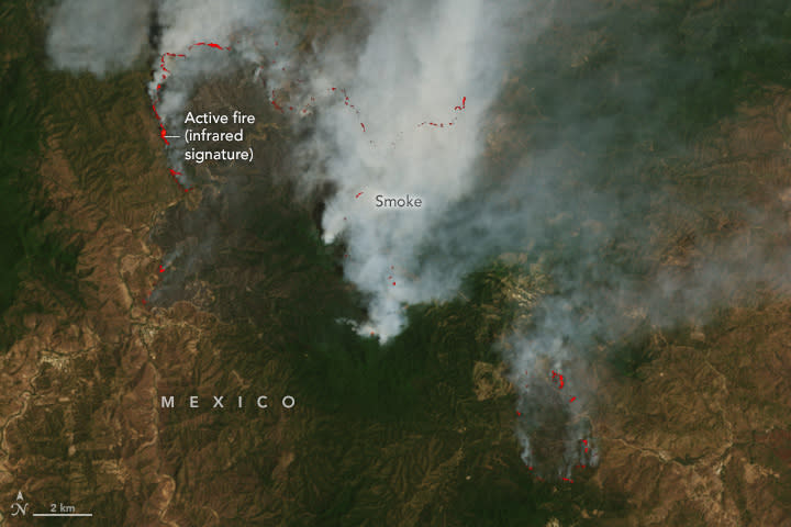
Firefighters have been battling this army of wildfires, which are scattered across various Canadian provinces, including over 30 blazes in Alberta and British Columbia and 10 in Ontario, according to the Canadian Interagency Forest Fire Centre. Smoke from multiple fires flowed into the United States and blanketed Wisconsin last Sunday (May 12), prompting the state's first air quality advisory of the year.
Related: Satellite images of Rafah illustrate Palestinians fleeing the city
NASA's Terra satellite, which is a small, school-bus-sized satellite circling Earth since 1999, imaged smoke from multiple fires in British Columbia and Alberta. Wisps of smoke can be seen swirling across North America in the new image, which was taken using the Moderate Resolution Imaging Spectroradiometer (MODIS) instrument onboard the satellite. The picture is a mosaic stitched from views taken during three separate passes of the satellite over the regions, NASA said in a statement.
In British Columbia, intense wildfires do not become widespread until late summer, so the ongoing blazes have sparked a fresh wave of concern about whether they are a sign of another deadly wildfire season. Last year's wildfire season was the country's worst on record, when more than 45 million acres burned across the country. However, less intense drought conditions compared to last year are expected to make this year's wildfire season less extreme, according to one New York Times article.
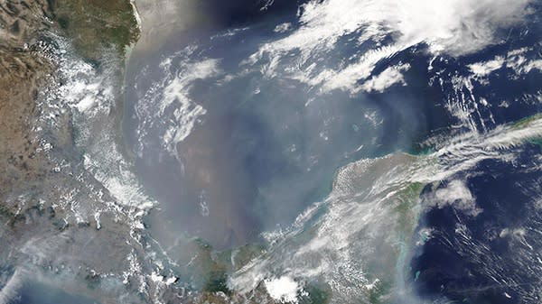
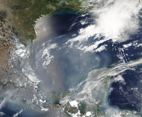
Meanwhile, more than 200 fires raged across Mexico last week, some of which were intentional and controlled in order to clear pasture and renew cropland, among other agricultural purposes, according to a NASA statement. The blazes coincide with the peak of the annual fire season, which usually begins mid-March and lasts for 14 weeks.
NASA's Aqua satellite, which circles our planet from south to north over the equator, imaged the smoke from some of the region's fires, which covered about two-thirds of the Gulf of Mexico. "In places, the smoke is so thick that it obscures the blue water beneath," the space agency wrote in the statement.
Prevailing winds ferried some of that smoke across the Gulf of Mexico and into southwest Florida, turning the state's normally sunshine-filled skies into a hazy expanse, Florida's local news outlet WINKnews.com reported.
Related Stories:
— Wildfire smoke is warming the planet more than previously thought, scientists say
— How scientists are using artificial intelligence to predict wildfires
— 'Lost' satellite found after orbiting undetected for 25 years
The Aqua satellite, which was launched in May 2002 to study water on Earth, has been in a "free-drift" mode since December 2021, when it completed its final maneuver to make up for atmospheric drag. NASA estimates the satellite "has a strong chance" of operating until September 2026.

