Severe storms move through parts of eastern Ontario and southern Quebec
Conditions are favourable for the formation of severe thunderstorms, which could produce tornadoes in parts of Ontario today. A line of stronger storms is expected to move eastward over eastern Ontario this evening. tornado warnings is in effect.
The main dangers associated with these thunderstorms will be damaging gusts and a risk of tornadoes. Large hail and locally heavy downpours are also a concern with the rounds of storms that move through.
7:41 PM EDT
All tornado watches and warnings have now been dropped for both Ontario and Quebec.
6:29 PM EDT:
All tornado warnings issued for Ontario and Quebec have been downgraded. A few tornado watches continue for areas in eastern Ontario.
10:56 AM EDT: Conditions are favourable for the formation of severe thunderstorms which could produce tornadoes. Strong winds, large hail and heavy rain are also possible.
Dangers: Strong gusts up to 90 km/h. Risk of tornadoes. Torrential rain.
Period: This afternoon.
This is a dangerous and potentially life-threatening situation. Take shelter immediately if a tornado warning is issued in your area. Tornado safety tips can be found here.
Be prepared for severe weather. Take cover immediately, if threatening weather approaches.
With thunderstorms moving through southern Ontario overnight, be sure to turn on Severe Weather Alert Notifications for your area by opening The Weather Network App and going to Settings > Notifications. #ONstorm #ONwx pic.twitter.com/wM5GfB0xGm
— The Weather Network (@weathernetwork) May 27, 2024
MUST SEE: How severe weather alerts are issued, and potentially save lives
Further forecast information can be found below.
STAY ALERT: Stronger storm chances build through the day Monday
The first wave of rain pushed over southwestern Ontario Sunday evening, with thunderstorms bubbling up across the region through the overnight and early morning hours. As the day carries on Monday, storms will continue to move eastward.

The threat for stronger, more organized storm development will increase in the afternoon and evening hours as the low-pressure system moves up across Georgian Bay and into eastern Ontario.
MUST SEE: Don’t fall victim to these seven dangerous tornado myths
Tornado threat across eastern Ontario and Quebec
Sections of eastern Ontario, including Ottawa, Brockville, Cornwall and Kingston, will see multiple rounds of rain and thunderstorms throughout the day, with the afternoon and evening storms bringing the greatest chance for more severe conditions, and the risk of tornadoes.
Sporadic damaging wind gusts are possible as the line of storms develops. Gusts could reach up to 90 km/h. Embedded within this line is also the chance for some nickel to quarter-sized hail.
The multiple rounds of rain will create a compounding effect, which brings the potential for torrential downpours and the risk for some localized flooding, as well.
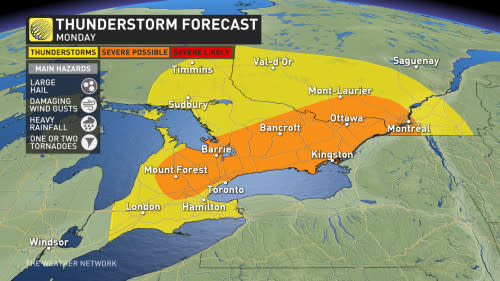
Another area to watch will be across parts of southwestern Ontario, including Mount Forest, Listowel, Orangeville, Kitchener, and while storms aren't expected to be quite as intense as eastern Ontario, there's still the chance for strong wind gusts and some nickel-sized hail.
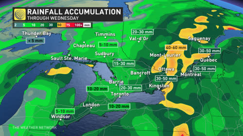
Regions that see multiple thunderstorms have the chance of receiving over 50+ mm of rainfall through Wednesday. Be on the lookout for localized flooding from the heavy rains and prepare for the possibility of power outages in areas that see high winds.
Stay alert for rapidly changing conditions in your area, and have a plan in place to seek shelter if dangerous weather threatens.
DON’T MISS: Ominous signs for hurricane season as Atlantic swelters, La Niña looms
WATCH: Storm Hunter Mark Robinson explains today's risk factors
Cooler than seasonal conditions as we head into June
Below-seasonal temperatures will dominate the final days of May and heading into the first week of June. Daytime highs will only reach the upper teens for most communities through Thursday, with sunshine for the latter half of the week pushing temperatures back toward the lower 20s.
Stay with The Weather Network for the latest on your stormy forecast across Ontario.

