Reports: Bomb cyclone cuts power to half a million as it wallops northeastern US
Damaging winds, coastal flooding and heavy snow will impact the northeastern United States through Friday due to a potent bomb cyclone.
Strong winds will howl across the region and may contribute to power outages from North Carolina to Maine. The strongest winds will likely be along the coast of eastern Massachusetts, where they will reach hurricane-force strength.
The strong onshore winds will lead to substantial coastal flooding and beach erosion in coastal areas.
Winds will not be as strong farther inland but can still contribute to power outages.
The heaviest snow is forecast over much of western New York and northern Pennsylvania, but several inches are possible in and around New York City.

11:07 a.m. EST Friday:
Tides are now 2.7 feet above normal in Boston and there are reports of flooding, according to AccuWeather Meteorologist Alex Sosnowski.
Along the north side of New York City, tides are about 2.5 feet above normal.
There are blowout tides at Baltimore Inner Harbor where the tide is about 1 foot below average. Water is being pushed out of the harbor and to the eastern side of the Chesapeake Bay, according to Sosnowski.
Flooding at long wharf. @NWSBoston pic.twitter.com/DbEUcxMq2R
— Rob Walsh (@Robbowalshie) March 2, 2018
Flooding in Weymouth Ma right now .@ShiriSpear @sarahwroblewski @JBrewerBoston25 @KevinBoston25 pic.twitter.com/a7Sj7pY0eq
— BigmouthBigbelly (@BigmouthBgbelly) March 2, 2018
10:44 a.m. EST Friday:
Rainy conditions are making travel more difficult across the Northeast. AccuWeather Reporter Jonathan Petramala shows the conditions at Newark Liberty International Airport (EWR) this morning.
Water building up on the runway made stopping the plane... interesting. #noreaster @accuweather @breakingweather pic.twitter.com/gLCXO06pyr
— Jonathan Petramala (@jpetramala) March 2, 2018
This is what it's like arriving at #Newark around 930 EST. Sort of bumpy. #noreaster @accuweather @breakingweather pic.twitter.com/coxIqT7UWX
— Jonathan Petramala (@jpetramala) March 2, 2018
10:05 a.m. EST Friday:
Follow AccuWeather's live broadcast coverage of the nor'easter bringing numerous impacts to the Northeast. We'll have studio updates on the storm every 30 minutes via the Facebook Live post below.
8:54 a.m. EST Friday:
The speed limit on Interstate 90 in Massachusetts has been reduced due to poor weather conditions.
Traffic conditions are also worsening on I-81 near Scranton, Pennsylvania.
This is Interstate 81 southbound in New Milford Twp. Tractor trailers stuck and partially blocking a lane of traffic. Wind is picking up and visibility is getting worse with every mile. @WNEP #pawx pic.twitter.com/tYN0Y5hxFX
— Michael Erat (@MichaelErat) March 2, 2018
8:21 a.m. EST Friday:
Based on a 24-hour pressure change from 29.87 inches to 29.16 inches, the powerful storm slamming the Northeast has officially undergone bombogenesis, according to AccuWeather Senior Meteorologist Alex Sosnowski.
Current satellite of Nor'easter: pic.twitter.com/t5ACi1ztLK
— Jesse Ferrell (@Accu_Jesse) March 2, 2018
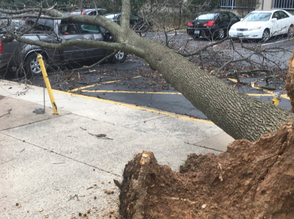
Strong winds from the bomb cyclone have downed a massive tree at the University of Maryland's campus in College Park.
There have been at least 70 reports of downed trees and power lines due to wind damage in Virginia and Maryland, with most occurring in the Washington, D.C., area, according to NWS spotters.
There were 64 reports of wind-damaged trees and power lines in Massachusetts Friday morning, mainly around Boston.
These winds mean business! We have tree damage on campus. This is how people can get seriously hurt. Stay safe Terps! @NWS_BaltWash (Via Erik Gates) pic.twitter.com/8TmTfpItbH
— UMD Weather (@UMD_Weather) March 2, 2018
Strong winds knocked a tree into a truck parked at an apartment complex in Fairfax, Virginia, just southwest of Washington, D.C. (Twitter photo/@lorenkaho)
Government offices in D.C. have closed due to the severe weather. At least 435,000 customers are now without power as a result of the bomb cyclone.
03/02: Federal offices in the DC area are closed. Emergency and telework-ready employees must follow their agency's policies. https://t.co/TiCGeSTFj9
— OPM (@USOPM) March 2, 2018
8:07 a.m. EST Friday:
Residents of Charlottesville, Virginia, are being impacted by power cuts, which have prompted Charlottesville City Schools to operate on a two-hour delay. Some schools in the area are also closed.
Please continue to be alert for for debris, trees & branches on roadways in #Cville. @DomEnergyVA reports ~1,900 w/o power in city.
— Charlottesville City (@CvilleCityHall) March 2, 2018
7:20 a.m. EST Friday:
Power outages continue to mount in Maryland, where more than 64,000 Maryland Utilities customers are now without power.
Power Outages as of 7AM. Updated information is here: https://t.co/4m8HB5GKCH pic.twitter.com/B2TFkkSTUC
— Maryland Emergency Management Agency (MDMEMA) (@MDMEMA) March 2, 2018
Wintry conditions are causing travel disruptions in Pennsylvania, where some highways, including I-90, are experiencing lane closures.
UPDATE: Winter weather on I-90 eastbound between Exit 37 - I-86 East and Exit 41 - PA 89/North East. All lanes closed.
— 511PA Erie (@511PAErie) March 2, 2018
Drivers in New York are also dealing with slick travel conditions. New York State Police warned on Twitter that although roads may appear to be clear, travelers should exercise caution as roads may be slippery.
Slow driving conditions on the roads this morning. This is video of 390 heading past the airport. Take your time this morning and exercise caution on the roads. @News_8 pic.twitter.com/qg6rBsR0AF
— Elijah Westbrook (@elijahwestbrook) March 2, 2018
Rising floodwaters from Jamaica Bay are beginning to cover some streets in parts of Queens, New York.
Flooded streets at high tide in Broad Channel Queens. Jamaica Bay rising over bulkheads. @wcbs880 pic.twitter.com/1wnwGbQneB
— Marla Diamond (@MDiamond8) March 2, 2018
7:01 a.m. EST Friday:
Heavy snow continues to fall across western New York as more than 18 inches of snow are being reported in East Aurora, New York, about 20 miles southeast of Buffalo.
Record-breaking snowfall has been reported in Buffalo, with 8.4 inches of snow observed at the airport thus far. This tops the previous record for this date, which was 6.5 inches of snowfall in 1914.
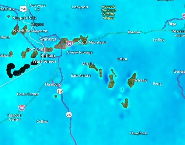
Parents measured 17 inches in Brocton, N.Y. @NWSBUFFALO @breakingweather pic.twitter.com/GcMuRtnXgo
— Steve Travis (@SteveDTravis) March 2, 2018
5:30 a.m. EST Friday:
All MARC Train Service has been suspended in Maryland as high winds have caused trees to fall on tracks.
MARC Train - all service suspended due to severe weather conditions, Federal Govt is closed, trees already falling on tracks and signal problems occurring. Safety is our first priority. Will update later today regarding Saturday Penn Line service.
— MTA Maryland (@mtamaryland) March 2, 2018
At least seven counties in the state have announced school closings on Friday. Numerous counties in Virginia have also announced school closings due to the storm.
All federal offices in the Washington, D.C., metro area are also closed.
5:00 a.m. EST Friday:
Power outages continue to mount across the mid-Atlantic, with wind gusts of 55-65 mph reported across Maryland and Virginia.
Nearly 35,000 customers are without power in Maryland, according to the state's emergency management agency.
The fire department in Salisbury, Maryland, is responding to a transformer fire in the city, where wind gusts past 40 mph have been reported.
Good Morning - these wind gusts are and should be taken seriously. If you can avoid traveling today, esp. This morning. Please do so. If not, leave early and slow your speed down. #MdWx #MDPrepares
— Maryland Emergency Management Agency (MDMEMA) (@MDMEMA) March 2, 2018
People commuting to work and school should use extreme caution as power lines and trees may block roads.
3:40 a.m. EST Friday:
Travel is extremely dangerous across interior portions of the Northeast as snow continues to fall at a rapid pace.
A majority of roads across New York state are completely covered with snow, according to 511NY.org.
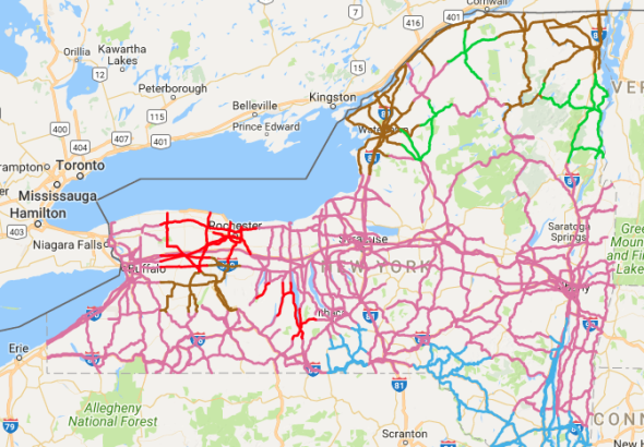
A majority of roads across New York state are completely covered with snow, as indicated by the pink and red shading. (Image/511NY)
As much as 3 inches of snow have already fallen near Albany, New York, with snow expected to persist through Friday.
2 a.m. EST Friday:
High winds are roaring into the mid-Atlantic, including in the Washington, D.C., and Baltimore metro areas.
In Kensington, Maryland, which lies just outside of the Capital Beltway, a 100-year-old resident was trapped in a bedroom after a tree fell on their house early Friday morning. According to Pete Piringer, chief spokesperson for Montgomery County Fire and Rescue Service, the person was rescued and transported to an area hospital. There is no word on the extent of their injury.
Update - E Bexhill Rd, Kensington, large tree on house, 1 occupant trapped in bedroom under debris, removed by FFs, EMS transported 100 yr old resident, Pri2 trauma, structural damage significant pic.twitter.com/XAZgPmKvIt
— Pete Piringer (@mcfrsPIO) March 2, 2018
Wind gusts have reached as high as 54 mph at Dulles International Airport. At Baltimore-Washington International Airport, winds are also picking up, with gusts to 44 mph.
12:45 a.m. EST Friday:
As winds continue to strengthen across the region, the number of power outages are mounting. In Pennsylvania, over 27,000 FirstEnergy Corp customers are without power, with that number expected to grow as gusty winds push across the state through Friday morning.
In southern West Virginia and southwestern Virginia, as many as 26,000 Appalachian Power customers are in the dark.
11:30 p.m. EST Thursday:
Thundersnow has been reported in Erie, Pennsylvania, with wind gusts as high as 54 mph. There have also been reports of thunder near Buffalo, New York.
[9:07pm] - We have #thundersnow! Lightning detected in southern Erie County. Any one hear it? #BUFwx #NYwx
— NWS Buffalo (@NWSBUFFALO) March 2, 2018
Yes! #Thundersnow over #Buffalo. Missed the first one, but got this second one! #wny #bufwx #nywx #BuffaloNY pic.twitter.com/420hyZ7v2B
— David Church (@warmbias) March 2, 2018
As much as 7-9 inches of snow have fallen across southwestern New York, with snow continuing to fall heavily. Portions of the state will be buried by over a foot of snow by the time the storm winds down late Friday. The combination of heavy, wet snow, as well as gusty winds, will weigh down trees and power lines.
[10pm] - Spotter in Franklinville reporting 8.8 inches of heavy, wet snow. Trees struggling under the weight of the snow. Photo credit: Dustin Brisky pic.twitter.com/7flvXMTpNH
— NWS Buffalo (@NWSBUFFALO) March 2, 2018
10:11 p.m. EST Thursday:
Communities and businesses across the northeastern U.S. are bracing for the impacts from the strengthening bomb cyclone.
Over 1,000 flights have already been canceled at airports across the region for Friday, according to FlightStats, with that number likely to rise throughout Friday. People with flights scheduled across the region on Friday should check with their airlines before heading to the airport.
Voluntary evacuations have been issued for Plum Island, Massachusetts, ahead of the potentially historic storm, according to WBZ.
8:45 p.m. EST Thursday:
Power outages are starting to climb across Ohio as winds grow stronger. Sustained winds in Cleveland have been over 20 mph since 5 p.m. EST, with wind gusts occasionally blowing past 40 mph.
The number of outages may continue to climb in Ohio as strong winds continue through Thursday night.
Over 50,000 customers without power in northeast Ohio due to these howling winds--number likely to grow as this heavy, wet snow continues to fall. Cuyahoga County leading the way with 13k, Lake and Lorain counties both with over 9k. #3weather #wkyc #firstenergy #poweroutage
— Matt Wintz (@WintzWeather) March 2, 2018
7:58 p.m. EST Thursday:
Rain is transitioning to snow across western New York and northern Ohio, with a burst of heavy snow moving through Cleveland.
Franklinville, New York, has received at least 5 inches of snow, with snowfall rates of 2 inches an hour, according to a National Weather Service trained spotter.
Several inches of snow have accumulated around Detroit, covering many roads across the area.
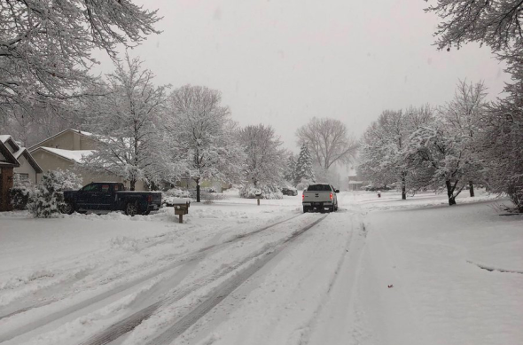
Snow-covered roads in Walled Lake, Michigan, located just north of Detroit. (Photo/Reed Timmer)
6:30 p.m. EST Thursday:
Heavy snow is creating some travel delays and slick roads in Detroit.
Heavy snow has been falling in Detroit much of the afternoon, with Detroit Metropolitan Wayne County Airport reporting over 300 flight delays so far today.
Heavy snow creating a not-so-pleasant evening commute in Detroit. pic.twitter.com/KhltSTIMMi
— Brian Thompson (@BrianThompsonWx) March 1, 2018
6 p.m. EST Thursday:
Wind advisories are in effect for areas across the northeastern U.S., including Suffern, New York. AccuWeather meteorologists are projecting winds to gust past 40 mph across much of the region, with some areas close to the coast potentially experiencing wind gusts past 60 mph.
WIND ADVISORY FOR SUFFERN AREA:
URGENT - WEATHER MESSAGE
National Weather Service New York NY
317 PM EST Thu... https://t.co/fLG8Gg1cgV— Suffern Police (@SuffernPolice) March 1, 2018
2:20 p.m. EST Thursday:
The National Weather Service is expanding their watches, warnings and advisories across the eastern U.S. as the bomb cyclone brews.
The National Guard has already been activated in Boston ahead of the storm in anticipation for major flooding and structural damage.
#GovBaker expects flooding and possible structural damage due to storm. He has activated the National Guard to assist locals. pic.twitter.com/9v3AufDEJH
— Lana Jones (@Lanawbz) March 1, 2018
Two powerful storm systems, one strengthening as it takes aim at the Northeast, and the other already pounding the West with heavy snow, can be seen churning in this satellite loop.
Head to https://t.co/VyWINDk3xP for the latest on what to expect in your area. pic.twitter.com/fesCS2VowH— NWS (@NWS) March 1, 2018

