'New' path of totality map shows more parts of Texas will get to see the solar eclipse
Despite modern technology, the sun's radius is difficult to measure. New data shows that the sun is a tad bigger than previously thought.
These new calculations have slightly shifted the solar eclipse's path of totality — just a week before the event.
People are also reading: Texas weather odds don't look good for solar eclipse as early forecasts show chance of rain
Expert John Irwin has recently published a new map with updated lines for the April 8 solar eclipse, Forbes reports.
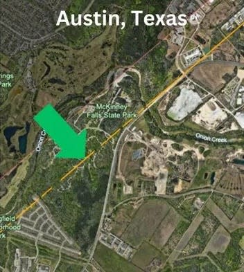
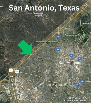
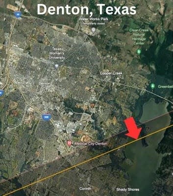
The red line shows the original path of totality, while the orange line represents the path updated with the new data.
A red arrow indicates a loss in the path of totality, and a green arrow shows a gain.
Here's what you need to know:
More: Still not sure where to see the solar eclipse in Texas? Here's a list of parks, watch parties
Updated total solar eclipse path of totality
Path of totality extends to McKinney Falls State Park in Austin
Though Austin-Bergstrom International Airport still remains outside the path of totality, McKinney Falls State Park is now included.
San Antonio's metro area to see more total darkness
The path of totality has widened to include slightly more of San Antonio's metropolitan area.
Denton loses part of the path of totality
Residents of Denton were originally advised to travel southeast to the southern half of Lewisville Lake, but now they might need to go farther to be within the path of totality.
Solar eclipse map: Path of totality in Texas
The map below is based on data from NASA, NOAA and the North Carolina Institute for Climate Studies to show eclipse times, peak sun coverage and likely levels of cloudiness during the solar eclipse April 8.
This article originally appeared on Austin American-Statesman: Solar Eclipse 2024: New data changes path of totality map in Texas
