Pair of storms to renew the risk for flooding from Texas to Florida this week


An already-soggy spring is about to get even wetter in the South. AccuWeather meteorologists are warning that a pair of storms moving from the Plains to the Atlantic Coast will again bring a risk of torrential downpours and flooding this week.
The threat for heavy rain comes on the heels of deadly major flooding that has impacted eastern Texas in recent days and weeks, leading to flood emergencies and swelling area rivers since early May. The prospect of more rain from thunderstorms as the two storms move through is raising eyebrows.
"Several inches of rain falling quickly, especially in areas north of Houston, could cause flooding issues yet again," said AccuWeather Senior Meteorologist Dan Pydynowski. "It is imperative for people to heed warnings from local officials to evacuate and get to safety if told to do so."
 |
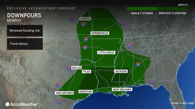
Following a relatively quiet start to the weekend, in the wake of the storm responsible for the most recent multiday outbreak of severe weather, the next storm moved in from the Rockies and Southwest on Sunday. This will be the first storm to renew the risk for flooding, as well as severe weather, first in the Southern Plains and Lower Mississippi Valley.
"Rounds of heavy rain into Monday can impact portions of northern Louisiana and eastern Texas," said Pydynowski. "These areas have been hit hard recently with devastating flooding."
In eastern Texas, up to 20 inches of rain has fallen since the beginning of May.
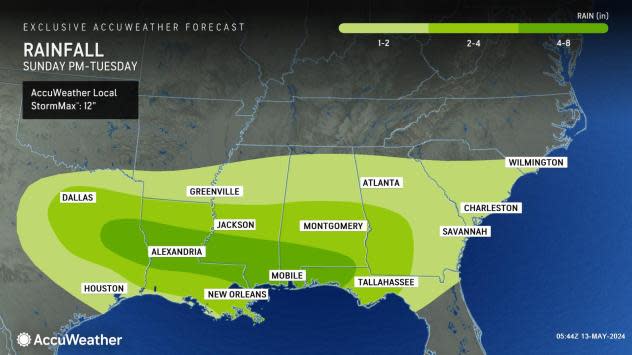
"With this first round of rain, a general 2-4 inches of rain is forecast, though there will be a zone where rainfall of 4-8 inches will occur," AccuWeather Senior Meteorologist Alex Sosnowski said. The AccuWeather Local StormMax™ for the rainfall is 12 inches. The heavy rain will spread eastward over the Southern states into Tuesday.
 |
It will not take much to cause flooding issues in the region, as the soil remains saturated, and rivers and streams are near or above bank full.
"This amount of rain alone is enough to trigger new small stream and low-lying area flooding and reverse recession along the secondary rivers," Sosnowski said, "And, with additional rounds of rain coming this week and next weekend, the situation could get very serious. Not only are there concerns for renewed problems in northeastern Texas, but there are also flash flooding concerns for the Interstate 35 corridor, and general river and small stream flooding farther to the east along the I-10 and 20 corridors of the Southern states."
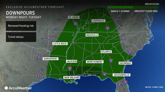
Accompanying the heavy rain will also be severe thunderstorms, as AccuWeather's severe weather experts say that the risk will reach its crescendo farther east toward the Mississippi Valley on Monday. These thunderstorms will be capable of producing localized damaging wind gusts, hail, and even some tornadoes.
For much of the Southeast, toward the Atlantic coast, the threat for heavy rain and flooding from thunderstorms will be delayed, but not denied.
"Though much of the Southeast enjoyed a dry Mother's Day weekend, the weather pattern will begin to change as the week progresses," said Pydynowski. "Moisture gathering farther west will make its way eastward into Alabama, Georgia, the Florida panhandle and the Carolinas by later Monday and Tuesday."
This area of the country has also been hit hard recently by heavy rain and severe weather. In the Tallahassee, Florida, area, at least one person died, and a few tornadoes touched down early on Friday. The cleanup efforts in the wake of those storms will be slowed by yet another round of drenching storms in the new week, including another risk of potentially severe storms on both Monday and Tuesday.
 |
"The soggy weather could make for a slow drive between Atlanta and Charlotte along the Interstate 85 corridor on Tuesday," added Pydynowski. "Torrential downpours can reduce visibility and leave standing water on some roadways."
Several inches of rain is expected in the Southeast, as well, before the first storm moves off the East Coast by Wednesday.
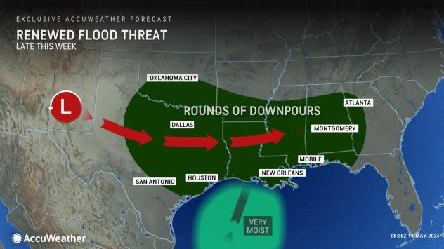
After the first storm soaks the South into early week, there will be little rest for the waterlogged and weary, as AccuWeather meteorologists will be tracking yet another storm expected to arrive on the scene in the Plains midweek.
While the exact locales that receive the heaviest rain remain to be determined, the storminess should impact many of the same areas along the Interstate 10 corridor from Texas to Georgia and Florida in the period from roughly Thursday through early Friday.
 |
Several more inches of rain will likely fall on top of what has already been received this month from this second storm.
"It's conceivable that some locations will pick up close to a foot of rain from the combination of the two storms that affect the region this week," Sosnowski said. Not only will that heavy rain renew the risk for flooding, but there can also be another risk for a few strong thunderstorms.
"We are watching the potential for yet another dose of drenching rain to erupt along the same saturated corridor of the Southern states next weekend," Sosnowski said, "I would be very surprised if there were not renewed flooding on some of the rivers that have had very high water recently as well as flooding along some of the rivers that have escaped flooding in the South-Central and Southeast states so far this spring."
While the rain is unwelcome in the corridor that has been dealing with flooding as of late, it would be welcomed in parts of southern Texas and South Florida, where there are currently drought conditions, according to the latest U.S. Drought Monitor released on Thursday. Unfortunately, it appears that the heaviest rain will miss these areas to the north.
Want next-level safety, ad-free? Unlock advanced, hyperlocal severe weather alerts when you subscribe to Premium+ on the AccuWeather app. AccuWeather Alerts™ are prompted by our expert meteorologists who monitor and analyze dangerous weather risks 24/7 to keep you and your family safer.
