Northeast I-95 corridor braces for feisty storms as heat, humidity build


Mother Nature has gotten the memo that the unofficial start to summer is quickly approaching, as heat and humidity are on the rise in the Northeast. The uptick in steamy weather may come with stormy consequences, AccuWeather forecasters say.
Temperatures were peaking Wednesday afternoon in the Northeast with widespread highs in the middle to upper 80s F, with some locations topping 90 degrees Fahrenheit for the first time this year. High humidity levels will make it feel even steamier.
Although temperatures fell short of record levels along the Interstate 95 corridor from Washington, D.C., to Boston, areas from western Maryland to southwestern Maine approached daily records. In Syracuse, New York, the 113-year-old daily record of 92 F was broken on Wednesday afternoon, with a new record of 93 F being set.
Those looking to cool off in bodies of water should use caution, as there is a lag between how quickly the air heats up and when the water warms. Most lake water temperatures are in the 50s and 60s F, and any water temperatures below 70 F can be dangerous.
Advancing thunderstorms will be another factor that people will need to take into account when spending time outside.
 |
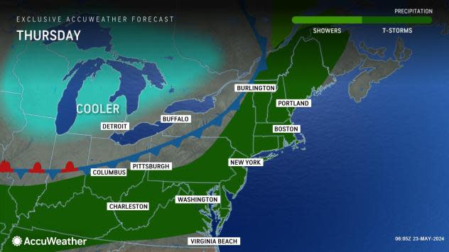
A cold front that AccuWeather meteorologists say could trigger a tornado outbreak into Tuesday night will press eastward into Thursday. As the cooler, less humid air behind this front clashes with the warm and humid conditions ahead, stormy weather will erupt.
"This front will bring the potential for severe weather that will cut through the summer heat and mugginess," AccuWeather Senior Meteorologist Tyler Roys said.
GET THE FREE ACCUWEATHER APP
•Have the app? Unlock AccuWeather Alerts™ with Premium+
Thunderstorms pushed eastward from the Ohio Valley and eastern Great Lakes regions to the central and northern Appalachians into Wednesday night. Strong, locally damaging winds, hail and downpours accompanied the strongest storms.
During any thunderstorm, regardless of its severity, lightning strikes pose a danger to those outdoors.
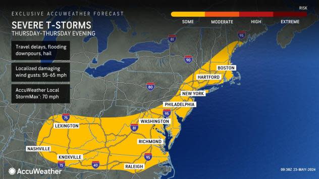
The front will dive farther to the south and east by Thursday, which will put the major metro areas along the bustling I-95 corridor in the risk zone for locally severe thunderstorms.
"Similar to midweek, storms can bring hail and damaging winds, but flooding downpours may also occur," Roys said. Poor drainage zones in urban areas are most likely to experience a buildup of water in any heavy thunderstorm.
"Although there can be some showers and thunderstorms around on Thursday morning, most of these storms will arrive in the big cities around the evening commute home, likely adding time to travel times," Roys said.
 |
Airline passengers may also face delays until the storms have cleared major hubs.
By Friday, a sweep of drier air will arrive across New York state and New England, but just enough moisture and an approaching storm may combine to keep spotty showers around through the Ohio Valley and part of the mid-Atlantic. Rain chances are expected to increase and expand in coverage across the Northeast over the extended Memorial Day weekend. Temperatures will trend lower into the weekend but will remain 5-10 degrees above historical averages.
 |
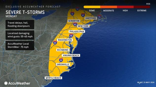
The next round of severe weather for the East Coast is likely to be on Memorial Day. Thunderstorms packing strong wind gusts, torrential downpours, frequent lightning strikes, and hail will affect part of the I-95 zone.
On Monday afternoon and evening, a few of the strongest storms could produce tornadoes.
Want next-level safety, ad-free? Unlock advanced, hyperlocal severe weather alerts when you subscribe to Premium+ on the AccuWeather app. AccuWeather Alerts™ are prompted by our expert meteorologists who monitor and analyze dangerous weather risks 24/7 to keep you and your family safer.
